Chinchiná elevation
Chinchiná (Caldas), Colombia elevation is 1382 meters and Chinchiná elevation in feet is 4534 ft above sea level [src 1]. Chinchiná is a seat of a second-order administrative division (feature code) with elevation that is 233 meters (764 ft) bigger than average city elevation in Colombia.
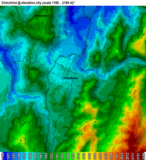
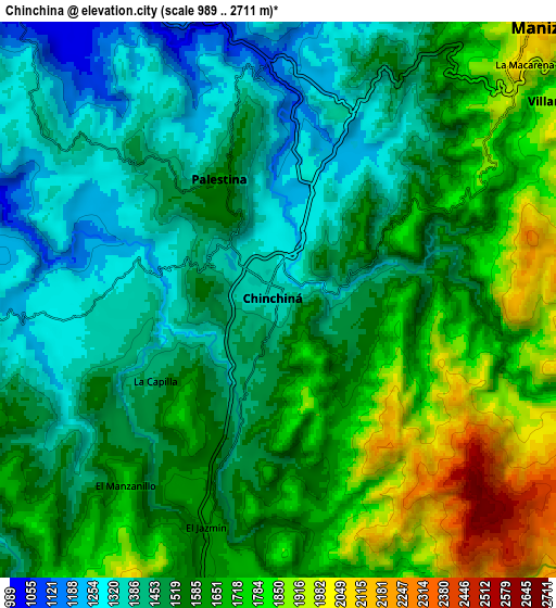
Below is the Elevation map of Chinchiná, which displays elevation range with different colors. Scale of the first map is from 1168 to 2190 m (3832 to 7185 ft) with average elevation of 1485.8 meters (=4875 ft) [note 1]
These maps also provides idea of topography and contour of this city, they are displayed at different zoom levels. More info about maps, scale and edge coordinates you can find below images.
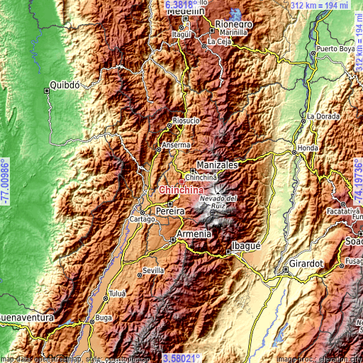
| \ | Map #1 | Map #2 | Topo.Map |
| Scale [m] | 1168..2190 m | 989..2711 m | × |
| Scale [ft] | 3832..7185 ft | 3245..8894 ft | × |
| Average | 1485.8 m = 4875 ft | 1569.8 m = 5150 ft | × |
| Width | 9.74 km = 6.1 mi | 19.47 km = 12.1 mi | 311.5 km = 193.6 mi |
| Height | 9.74 km = 6.1 mi | 19.47 km = 12.1 mi | 311.5 km = 193.6 mi |
| ↑Max Latitude | 5.026278° | 5.070053° | 6.3818° |
| Latitude at center | 4.9825° | 4.9825° | 4.9825° |
| ↓Min Latitude | 4.938719° | 4.894936° | 3.58021° |
| ← Min Longitude | -75.647555° | -75.691501° | -77.00986° |
| Longitude center | -75.60361° | -75.60361° | -75.60361° |
| →Max Longitude | -75.559665° | -75.515719° | -74.19736° |
Nearby cities:
Cities around Chinchiná sort by population:
• Pereira elevation 1414 m
21.4 km,  208°
208°
• Manizales 2119 m
13.5 km,  44°
44°
• Dosquebradas 1454 m
17.4 km,  203°
203°
• Santa Rosa de Cabal 1691 m
12.9 km,  188°
188°
• Villamaría 1887 m
12.1 km,  54°
54°
• Viterbo 976 m
31 km,  286°
286°
• Neira 1953 m
22.5 km,  24°
24°
• Marsella 1543 m
15.7 km,  251°
251°
• Palestina 1527 m
4.6 km,  323°
323°
• Belalcázar 1591 m
23.2 km,  273°
273°
• Risaralda 1728 m
27.2 km, 318°
• San José 1491 m
23.5 km,  298°
298°
Multilingual:
 En español:
Chinchiná elevación 1382 m.
 En France:
Chinchiná élévation 1382 m.
 Auf Deutsch:
Chinchiná höhe über dem Meeresspiegel ist 1382 m.

Sources and notes:
- [note 1] Map square and city borders are not equal. Map elevation data is calculated only from area inside that square.
- [src 1] Elevation data from geonames database provided with same terms of usage.
- [src 2] The elevation map of Chinchiná is generated using elevation data from NASA's 3 arcsec (90m) resolution SRTM data.
- [src 3] Base (background) map © OpenStreetMap contributors tiles are generated by Geofabrik and OpenTopoMap.
Copyright & License:
This Chinchiná Elevation Map is licensed under CC BY-SA. You may reuse any part from this page, if you give a proper credit by linking to this URL:
 More info on terms of use page.