Santa Rosa de Cabal elevation
Santa Rosa de Cabal (Risaralda), Colombia elevation is 1691 meters and Santa Rosa de Cabal elevation in feet is 5548 ft above sea level [src 1]. Santa Rosa de Cabal is a seat of a second-order administrative division (feature code) with elevation that is 542 meters (1778 ft) bigger than average city elevation in Colombia.
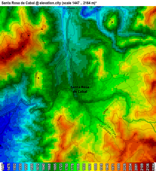
Below is the Elevation map of Santa Rosa de Cabal, which displays elevation range with different colors. Scale of the first map is from 1447 to 2164 m (4747 to 7100 ft) with average elevation of 1769.7 meters (=5806 ft) [note 1]
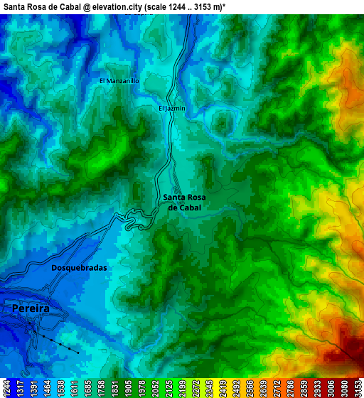
These maps also provides idea of topography and contour of this city, they are displayed at different zoom levels. More info about maps, scale and edge coordinates you can find below images.
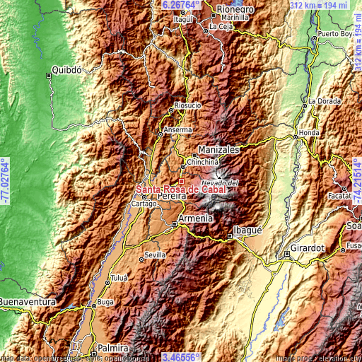
| \ | Map #1 | Map #2 | Topo.Map |
| Scale [m] | 1447..2164 m | 1244..3153 m | × |
| Scale [ft] | 4747..7100 ft | 4081..10344 ft | × |
| Average | 1769.7 m = 5806 ft | 1815.1 m = 5955 ft | × |
| Width | 9.74 km = 6.1 mi | 19.47 km = 12.1 mi | 311.6 km = 193.6 mi |
| Height | 9.74 km = 6.1 mi | 19.47 km = 12.1 mi | 311.6 km = 193.6 mi |
| ↑Max Latitude | 4.911845° | 4.955628° | 6.26764° |
| Latitude at center | 4.86806° | 4.86806° | 4.86806° |
| ↓Min Latitude | 4.824272° | 4.780481° | 3.46556° |
| ← Min Longitude | -75.665335° | -75.709281° | -77.02764° |
| Longitude center | -75.62139° | -75.62139° | -75.62139° |
| →Max Longitude | -75.577445° | -75.533499° | -74.21514° |
Nearby cities:
Cities around Santa Rosa de Cabal sort by population:
• Pereira elevation 1414 m
10.3 km,  233°
233°
• Manizales 2119 m
25.1 km,  27°
27°
• Dosquebradas 1454 m
6 km,  237°
237°
• Chinchiná 1382 m
12.9 km,  8°
8°
• Villamaría 1887 m
23 km, 30°
• Circasia 1772 m
27.8 km,  183°
183°
• Marsella 1543 m
15 km,  300°
300°
• Palestina 1527 m
16.5 km,  357°
357°
• Filandia 1919 m
21.9 km,  190°
190°
• Belalcázar 1591 m
25.5 km, 303°
• Salento 1995 m
26.3 km,  167°
167°
• Ulloa 1353 m
22.5 km,  215°
215°
Multilingual:
 En español:
Santa Rosa de Cabal elevación 1691 m.
 En France:
Santa Rosa de Cabal élévation 1691 m.
 Auf Deutsch:
Santa Rosa de Cabal höhe über dem Meeresspiegel ist 1691 m.
 На русском:
Санта-Роса-де-Кабаль высота над уровнем моря 1691 м
Sources and notes:
- [note 1] Map square and city borders are not equal. Map elevation data is calculated only from area inside that square.
- [src 1] Elevation data from geonames database provided with same terms of usage.
- [src 2] The elevation map of Santa Rosa de Cabal is generated using elevation data from NASA's 3 arcsec (90m) resolution SRTM data.
- [src 3] Base (background) map © OpenStreetMap contributors tiles are generated by Geofabrik and OpenTopoMap.
Copyright & License:
This Santa Rosa de Cabal Elevation Map is licensed under CC BY-SA. You may reuse any part from this page, if you give a proper credit by linking to this URL:
 More info on terms of use page.