Cubará elevation
Cubará (Boyacá), Colombia elevation is 351 meters and Cubará elevation in feet is 1152 ft above sea level [src 1]. Cubará is a seat of a second-order administrative division (feature code) with elevation that is 798 meters (2618 ft) smaller than average city elevation in Colombia.
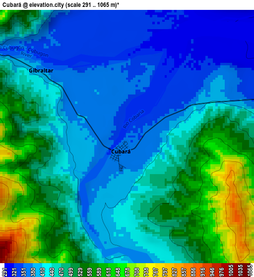
Below is the Elevation map of Cubará, which displays elevation range with different colors. Scale of the first map is from 291 to 1065 m (955 to 3494 ft) with average elevation of 462.8 meters (=1518 ft) [note 1]
These maps also provides idea of topography and contour of this city, they are displayed at different zoom levels. More info about maps, scale and edge coordinates you can find below images.
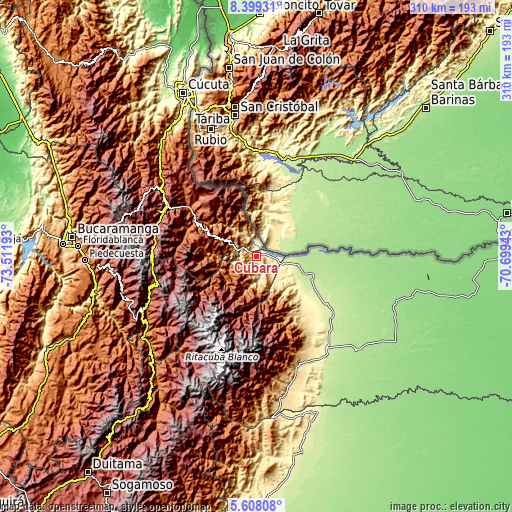
| \ | Map #1 | Topo.Map |
| Scale [m] | 291..1065 m | × |
| Scale [ft] | 955..3494 ft | × |
| Average | 462.8 m = 1518 ft | × |
| Width | 9.7 km = 6 mi | 310.4 km = 192.9 mi |
| Height | 9.7 km = 6 mi | 310.4 km = 192.9 mi |
| ↑Max Latitude | 7.049395° | 8.39931° |
| Latitude at center | 7.00578° | 7.00578° |
| ↓Min Latitude | 6.962161° | 5.60808° |
| ← Min Longitude | -72.149625° | -73.51193° |
| Longitude center | -72.10568° | -72.10568° |
| →Max Longitude | -72.061735° | -70.69943° |
Nearby cities:
Cities around Cubará sort by population:
• Toledo elevation 1638 m
53.6 km,  309°
309°
• Fortul 241 m
43.4 km,  123°
123°
• Chitagá 2352 m
63.4 km,  283°
283°
• Concepción 1990 m
70.2 km,  247°
247°
• Cerrito 2512 m
67.4 km, 254°
• Güicán 2820 m
69.1 km,  209°
209°
• Herrán 1960 m
69.5 km,  323°
323°
• Cácota 2407 m
66 km,  296°
296°
• Chiscas 2404 m
66.5 km,  221°
221°
• Carcasí 2107 m
71.2 km,  233°
233°
• Labateca 1553 m
53.9 km, 307°
• Saravena 225 m
25.1 km,  100°
100°
Multilingual:
 En español:
Cubará elevación 351 m.
 En France:
Cubará élévation 351 m.


Sources and notes:
- [note 1] Map square and city borders are not equal. Map elevation data is calculated only from area inside that square.
- [src 1] Elevation data from geonames database provided with same terms of usage.
- [src 2] The elevation map of Cubará is generated using elevation data from NASA's 3 arcsec (90m) resolution SRTM data.
- [src 3] Base (background) map © OpenStreetMap contributors tiles are generated by Geofabrik and OpenTopoMap.
Copyright & License:
This Cubará Elevation Map is licensed under CC BY-SA. You may reuse any part from this page, if you give a proper credit by linking to this URL:
 More info on terms of use page.