Ebéjico elevation
Ebéjico (Antioquia), Colombia elevation is 1159 meters and Ebéjico elevation in feet is 3802 ft above sea level [src 1]. Ebéjico is a seat of a second-order administrative division (feature code) with elevation that is 10 meters (33 ft) bigger than average city elevation in Colombia.
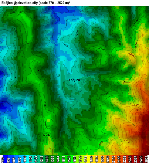
Below is the Elevation map of Ebéjico, which displays elevation range with different colors. Scale of the first map is from 770 to 2522 m (2526 to 8274 ft) with average elevation of 1409.5 meters (=4624 ft) [note 1]
These maps also provides idea of topography and contour of this city, they are displayed at different zoom levels. More info about maps, scale and edge coordinates you can find below images.
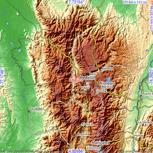
| \ | Map #1 | Topo.Map |
| Scale [m] | 770..2522 m | × |
| Scale [ft] | 2526..8274 ft | × |
| Average | 1409.5 m = 4624 ft | × |
| Width | 9.71 km = 6 mi | 310.8 km = 193.1 mi |
| Height | 9.71 km = 6 mi | 310.8 km = 193.1 mi |
| ↑Max Latitude | 6.369656° | 7.72164° |
| Latitude at center | 6.32598° | 6.32598° |
| ↓Min Latitude | 6.2823° | 4.92654° |
| ← Min Longitude | -75.812295° | -77.1746° |
| Longitude center | -75.76835° | -75.76835° |
| →Max Longitude | -75.724405° | -74.3621° |
Nearby cities:
Cities around Ebéjico sort by population:
• Medellín elevation 1500 m
24.1 km,  110°
110°
• Bello 1456 m
23.3 km,  86°
86°
• Itagüí 1538 m
24.4 km,  130°
130°
• La Estrella 1765 m
23.3 km,  143°
143°
• Sabaneta 1592 m
25.6 km, 139°
• San Jerónimo 728 m
13.8 km,  18°
18°
• Heliconia 1387 m
13.6 km,  164°
164°
• Armenia 1822 m
19 km,  186°
186°
• Angelópolis 1898 m
24.8 km, 164°
• Caicedo 1794 m
25.3 km,  290°
290°
• Sopetrán 759 m
19.7 km,  8°
8°
• Anzá 649 m
9.8 km,  255°
255°
Multilingual:
 En español:
Ebéjico elevación 1159 m.
 En France:
Ebéjico élévation 1159 m.
 Auf Deutsch:
Ebéjico höhe über dem Meeresspiegel ist 1159 m.

Sources and notes:
- [note 1] Map square and city borders are not equal. Map elevation data is calculated only from area inside that square.
- [src 1] Elevation data from geonames database provided with same terms of usage.
- [src 2] The elevation map of Ebéjico is generated using elevation data from NASA's 3 arcsec (90m) resolution SRTM data.
- [src 3] Base (background) map © OpenStreetMap contributors tiles are generated by Geofabrik and OpenTopoMap.
Copyright & License:
This Ebéjico Elevation Map is licensed under CC BY-SA. You may reuse any part from this page, if you give a proper credit by linking to this URL:
 More info on terms of use page.