La Chamba elevation
La Chamba (Tolima, Guamo), Colombia elevation is 294 meters and La Chamba elevation in feet is 965 ft above sea level [src 1]. La Chamba is a populated place (feature code) with elevation that is 855 meters (2805 ft) smaller than average city elevation in Colombia.
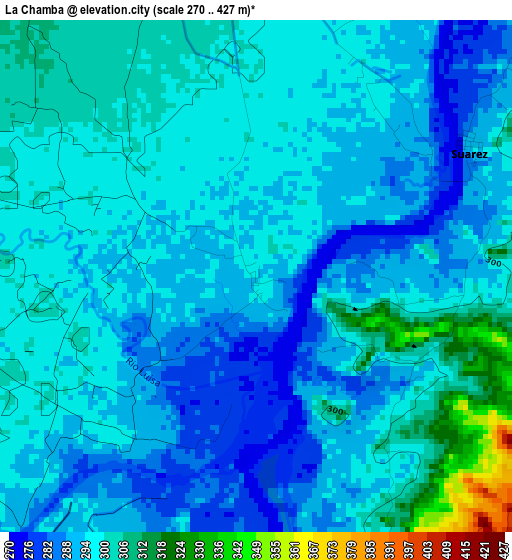
Below is the Elevation map of La Chamba, which displays elevation range with different colors. Scale of the first map is from 270 to 427 m (886 to 1401 ft) with average elevation of 296.6 meters (=973 ft) [note 1]
These maps also provides idea of topography and contour of this city, they are displayed at different zoom levels. More info about maps, scale and edge coordinates you can find below images.
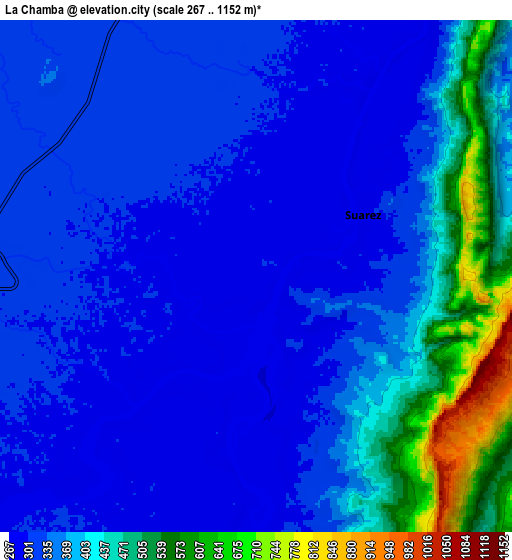
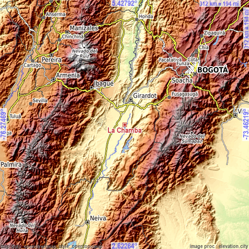
| \ | Map #1 | Map #2 | Topo.Map |
| Scale [m] | 270..427 m | 267..1152 m | × |
| Scale [ft] | 886..1401 ft | 876..3780 ft | × |
| Average | 296.6 m = 973 ft | 367 m = 1204 ft | × |
| Width | 9.75 km = 6.1 mi | 19.5 km = 12.1 mi | 311.9 km = 193.8 mi |
| Height | 9.75 km = 6.1 mi | 19.5 km = 12.1 mi | 311.9 km = 193.8 mi |
| ↑Max Latitude | 4.070326° | 4.114159° | 5.42792° |
| Latitude at center | 4.02649° | 4.02649° | 4.02649° |
| ↓Min Latitude | 3.982652° | 3.938812° | 2.62264° |
| ← Min Longitude | -74.912385° | -74.956331° | -76.27469° |
| Longitude center | -74.86844° | -74.86844° | -74.86844° |
| →Max Longitude | -74.824495° | -74.780549° | -73.46219° |
Nearby cities:
Cities around La Chamba sort by population:
• Espinal elevation 323 m
13.8 km,  352°
352°
• Flandes 285 m
29.9 km,  11°
11°
• Guamo 323 m
11.3 km,  272°
272°
• Chicoral 409 m
24.5 km,  329°
329°
• Purificación 305 m
19.9 km,  200°
200°
• Saldaña 311 m
19.5 km,  236°
236°
• Carmen de Apicalá 315 m
21.2 km,  50°
50°
• San Luis 478 m
27.8 km,  295°
295°
• Cunday 457 m
19.9 km,  79°
79°
• Suárez 292 m
4.8 km,  58°
58°
• Tres Esquinas 1164 m
25.2 km,  135°
135°
• Coello 298 m
29.4 km, 353°
Multilingual:
 En español:
La Chamba elevación 294 m.
 En France:
La Chamba élévation 294 m.
 Auf Deutsch:
La Chamba höhe über dem Meeresspiegel ist 294 m.

Sources and notes:
- [note 1] Map square and city borders are not equal. Map elevation data is calculated only from area inside that square.
- [src 1] Elevation data from geonames database provided with same terms of usage.
- [src 2] The elevation map of La Chamba is generated using elevation data from NASA's 3 arcsec (90m) resolution SRTM data.
- [src 3] Base (background) map © OpenStreetMap contributors tiles are generated by Geofabrik and OpenTopoMap.
Copyright & License:
This La Chamba Elevation Map is licensed under CC BY-SA. You may reuse any part from this page, if you give a proper credit by linking to this URL:
 More info on terms of use page.