López elevation
López (Cauca, Municipio de López de Micay), Colombia elevation is 36 meters and López elevation in feet is 118 ft above sea level [src 1]. López is a seat of a second-order administrative division (feature code) with elevation that is 1113 meters (3652 ft) smaller than average city elevation in Colombia.
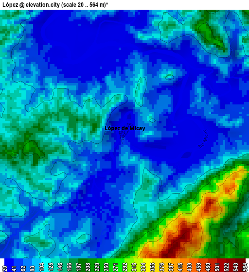
Below is the Elevation map of López, which displays elevation range with different colors. Scale of the first map is from 20 to 564 m (66 to 1850 ft) with average elevation of 108.7 meters (=357 ft) [note 1]
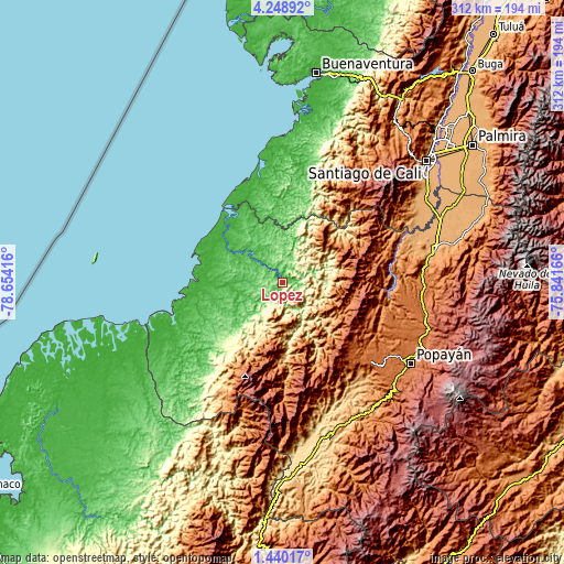
These maps also provides idea of topography and contour of this city, they are displayed at different zoom levels. More info about maps, scale and edge coordinates you can find below images.
| \ | Map #1 | Topo.Map |
| Scale [m] | 20..564 m | × |
| Scale [ft] | 66..1850 ft | × |
| Average | 108.7 m = 357 ft | × |
| Width | 9.76 km = 6.1 mi | 312.3 km = 194.1 mi |
| Height | 9.76 km = 6.1 mi | 312.3 km = 194.1 mi |
| ↑Max Latitude | 2.88929° | 4.24892° |
| Latitude at center | 2.8454° | 2.8454° |
| ↓Min Latitude | 2.801508° | 1.44017° |
| ← Min Longitude | -77.291855° | -78.65416° |
| Longitude center | -77.24791° | -77.24791° |
| →Max Longitude | -77.203965° | -75.84166° |
Nearby cities:
Cities around López sort by population:
• Piendamo elevation 1868 m
82.9 km,  106°
106°
• Morales 1814 m
69.6 km,  98°
98°
• Guapí 3 m
77.1 km,  246°
246°
• Suárez 1075 m
62.4 km,  78°
78°
• Villa Rica 1737 m
57.6 km,  129°
129°
• El Tambo 1719 m
65.4 km, 131°
• Timbiquí 4 m
47.1 km,  259°
259°
• Argelia 1256 m
65.6 km,  180°
180°
• López 1791 m
67.6 km, 132°
• Cajibío 1826 m
79.2 km, 108°
• Buenos Aires 1200 m
69.4 km,  74°
74°
• Timbío 1790 m
83.4 km, 131°
Multilingual:
 En español:
López elevación 36 m.
 En France:
López élévation 36 m.


Sources and notes:
- [note 1] Map square and city borders are not equal. Map elevation data is calculated only from area inside that square.
- [src 1] Elevation data from geonames database provided with same terms of usage.
- [src 2] The elevation map of López is generated using elevation data from NASA's 3 arcsec (90m) resolution SRTM data.
- [src 3] Base (background) map © OpenStreetMap contributors tiles are generated by Geofabrik and OpenTopoMap.
Copyright & License:
This López Elevation Map is licensed under CC BY-SA. You may reuse any part from this page, if you give a proper credit by linking to this URL:
 More info on terms of use page.