Argelia elevation
Argelia (Cauca), Colombia elevation is 1256 meters and Argelia elevation in feet is 4121 ft above sea level [src 1]. Argelia is a seat of a second-order administrative division (feature code) with elevation that is 107 meters (351 ft) bigger than average city elevation in Colombia.
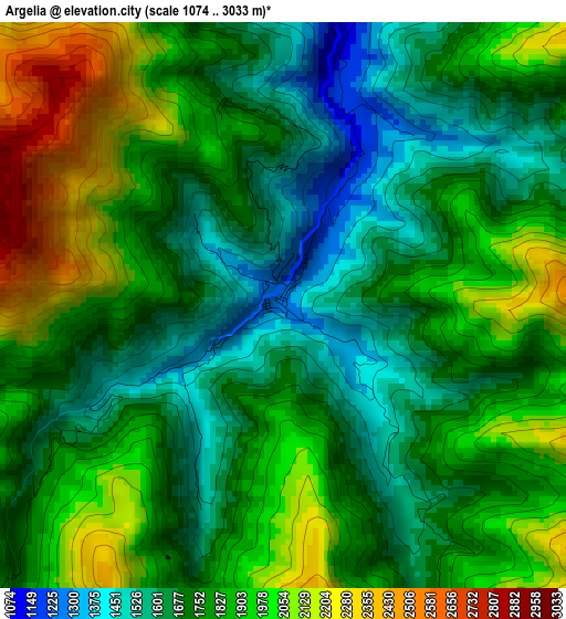
Below is the Elevation map of Argelia, which displays elevation range with different colors. Scale of the first map is from 1074 to 3033 m (3524 to 9951 ft) with average elevation of 1809 meters (=5935 ft) [note 1]
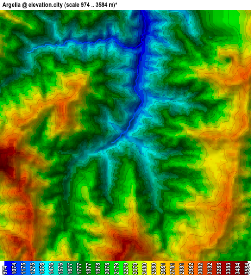
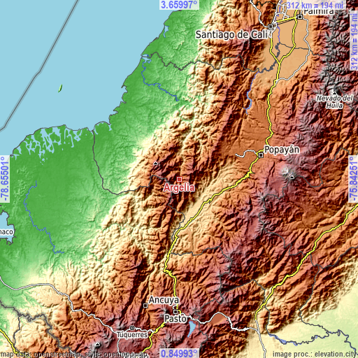
These maps also provides idea of topography and contour of this city, they are displayed at different zoom levels. More info about maps, scale and edge coordinates you can find below images.
| \ | Map #1 | Map #2 | Topo.Map |
| Scale [m] | 1074..3033 m | 974..3584 m | × |
| Scale [ft] | 3524..9951 ft | 3196..11759 ft | × |
| Average | 1809 m = 5935 ft | 2142.7 m = 7030 ft | × |
| Width | 9.76 km = 6.1 mi | 19.53 km = 12.1 mi | 312.4 km = 194.1 mi |
| Height | 9.77 km = 6.1 mi | 19.53 km = 12.1 mi | 312.5 km = 194.2 mi |
| ↑Max Latitude | 2.299541° | 2.34345° | 3.65997° |
| Latitude at center | 2.25563° | 2.25563° | 2.25563° |
| ↓Min Latitude | 2.211718° | 2.167805° | 0.84993° |
| ← Min Longitude | -77.292705° | -77.336651° | -78.65501° |
| Longitude center | -77.24876° | -77.24876° | -77.24876° |
| →Max Longitude | -77.204815° | -77.160869° | -75.84251° |
Nearby cities:
Cities around Argelia sort by population:
• Patía elevation 619 m
30.1 km,  133°
133°
• El Bordo 990 m
33.4 km,  117°
117°
• Villa Rica 1737 m
52.9 km,  57°
57°
• El Tambo 1719 m
53.4 km,  65°
65°
• Balboa 2142 m
24 km,  171°
171°
• Mercaderes 1132 m
51.2 km, 170°
• López 1791 m
53.6 km, 68°
• Leiva 1582 m
36.2 km,  190°
190°
• Sucre 1138 m
43.4 km, 123°
• La Sierra 1776 m
54.7 km,  99°
99°
• Rosas 1717 m
56.5 km,  89°
89°
• Bolívar 1770 m
55.7 km,  146°
146°
Multilingual:
 En español:
Argelia elevación 1256 m.
 En France:
Argelia élévation 1256 m.
 Auf Deutsch:
Argelia höhe über dem Meeresspiegel ist 1256 m.

Sources and notes:
- [note 1] Map square and city borders are not equal. Map elevation data is calculated only from area inside that square.
- [src 1] Elevation data from geonames database provided with same terms of usage.
- [src 2] The elevation map of Argelia is generated using elevation data from NASA's 3 arcsec (90m) resolution SRTM data.
- [src 3] Base (background) map © OpenStreetMap contributors tiles are generated by Geofabrik and OpenTopoMap.
Copyright & License:
This Argelia Elevation Map is licensed under CC BY-SA. You may reuse any part from this page, if you give a proper credit by linking to this URL:
 More info on terms of use page.