María la Baja elevation
María la Baja (Bolívar, Municipio de María la Baja), Colombia elevation is 15 meters and María la Baja elevation in feet is 49 ft above sea level [src 1]. María la Baja is a seat of a second-order administrative division (feature code) with elevation that is 1134 meters (3720 ft) smaller than average city elevation in Colombia.
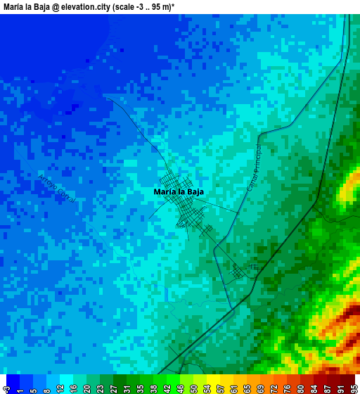
Below is the Elevation map of María la Baja, which displays elevation range with different colors. Scale of the first map is from -3 to 95 m (-10 to 312 ft) with average elevation of 15.2 meters (=50 ft) [note 1]
These maps also provides idea of topography and contour of this city, they are displayed at different zoom levels. More info about maps, scale and edge coordinates you can find below images.
| \ | Map #1 | Map #2 | Topo.Map |
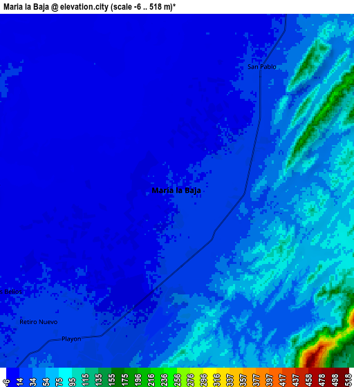
| Scale [m] | -3..95 m | -6..518 m | × |
| Scale [ft] | -10..312 ft | -20..1699 ft | × |
| Average | 15.2 m = 50 ft | 32.3 m = 106 ft | × |
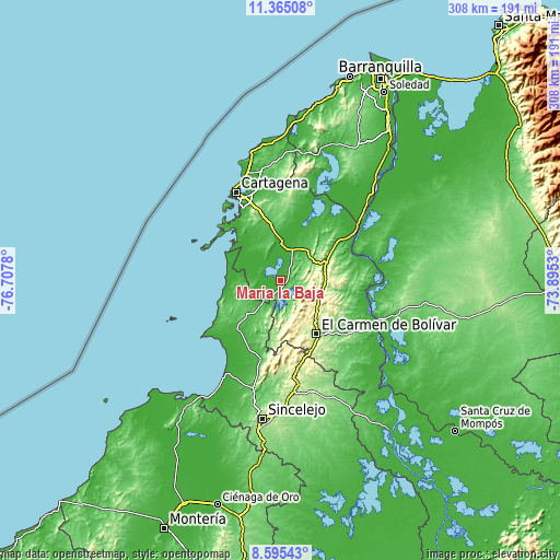
| Width | 9.62 km = 6 mi | 19.25 km = 12 mi | 308 km = 191.4 mi |
| Height | 9.62 km = 6 mi | 19.25 km = 12 mi | 308 km = 191.4 mi |
| ↑Max Latitude | 10.026477° | 10.069748° | 11.36508° |
| Latitude at center | 9.9832° | 9.9832° | 9.9832° |
| ↓Min Latitude | 9.939917° | 9.896629° | 8.59543° |
| ← Min Longitude | -75.345495° | -75.389441° | -76.7078° |
| Longitude center | -75.30155° | -75.30155° | -75.30155° |
| →Max Longitude | -75.257605° | -75.213659° | -73.8953° |
Nearby cities:
Cities around María la Baja sort by population:
• Turbaco elevation 174 m
40.3 km,  342°
342°
• Arjona 62 m
30.5 km,  351°
351°
• El Carmen de Bolívar 153 m
35.6 km,  146°
146°
• San Onofre 37 m
36.9 km,  221°
221°
• San Juan Nepomuceno 172 m
24.3 km,  98°
98°
• San Jacinto 235 m
26.2 km,  131°
131°
• San Pablo 14 m
8.5 km,  25°
25°
• Turbaná 86 m
35.6 km,  334°
334°
• Mahates 10 m
30.3 km,  23°
23°
• San Cristóbal 89 m
12.9 km,  155°
155°
• El Guamo 73 m
36 km,  81°
81°
• Arroyohondo 30 m
43 km,  45°
45°
Multilingual:
 En español:
María la Baja elevación 15 m.
 En France:
María la Baja élévation 15 m.
 Auf Deutsch:
María la Baja höhe über dem Meeresspiegel ist 15 m.

Sources and notes:
- [note 1] Map square and city borders are not equal. Map elevation data is calculated only from area inside that square.
- [src 1] Elevation data from geonames database provided with same terms of usage.
- [src 2] The elevation map of María la Baja is generated using elevation data from NASA's 3 arcsec (90m) resolution SRTM data.
- [src 3] Base (background) map © OpenStreetMap contributors tiles are generated by Geofabrik and OpenTopoMap.
Copyright & License:
This María la Baja Elevation Map is licensed under CC BY-SA. You may reuse any part from this page, if you give a proper credit by linking to this URL:
 More info on terms of use page.