Oiba elevation
Oiba (Santander), Colombia elevation is 1421 meters and Oiba elevation in feet is 4662 ft above sea level [src 1]. Oiba is a seat of a second-order administrative division (feature code) with elevation that is 272 meters (892 ft) bigger than average city elevation in Colombia.
Below is the Elevation map of Oiba, which displays elevation range with different colors. Scale of the first map is from 1246 to 1942 m (4088 to 6371 ft) with average elevation of 1577.3 meters (=5175 ft) [note 1]
These maps also provides idea of topography and contour of this city, they are displayed at different zoom levels. More info about maps, scale and edge coordinates you can find below images.
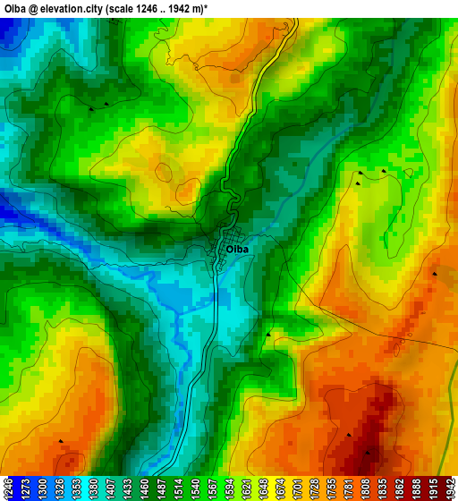
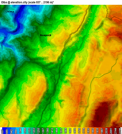
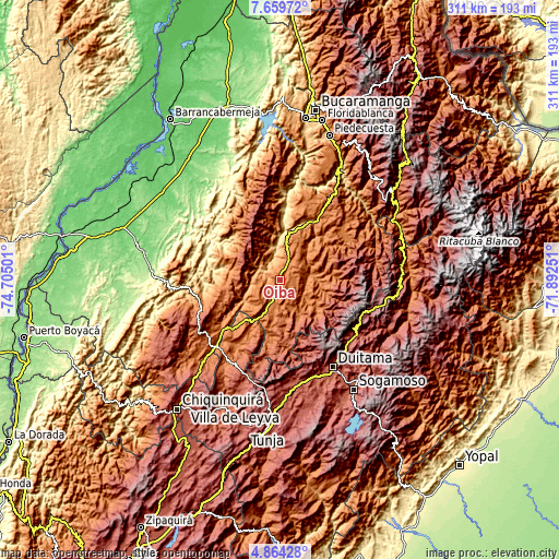
| \ | Map #1 | Map #2 | Topo.Map |
| Scale [m] | 1246..1942 m | 837..2196 m | × |
| Scale [ft] | 4088..6371 ft | 2746..7205 ft | × |
| Average | 1577.3 m = 5175 ft | 1556.6 m = 5107 ft | × |
| Width | 9.71 km = 6 mi | 19.43 km = 12.1 mi | 310.8 km = 193.1 mi |
| Height | 9.71 km = 6 mi | 19.43 km = 12.1 mi | 310.9 km = 193.2 mi |
| ↑Max Latitude | 6.307551° | 6.351229° | 7.65972° |
| Latitude at center | 6.26387° | 6.26387° | 6.26387° |
| ↓Min Latitude | 6.220185° | 6.176497° | 4.86428° |
| ← Min Longitude | -73.342705° | -73.386651° | -74.70501° |
| Longitude center | -73.29876° | -73.29876° | -73.29876° |
| →Max Longitude | -73.254815° | -73.210869° | -71.89251° |
Nearby cities:
Cities around Oiba sort by population:
• Socorro elevation 1234 m
23.1 km,  10°
10°
• Contratación 1645 m
19.5 km,  278°
278°
• Guadalupe 1444 m
13.4 km,  261°
261°
• Simacota 1057 m
20.3 km,  348°
348°
• Ocamonte 1409 m
21.3 km,  66°
66°
• Páramo 1406 m
22.1 km,  39°
39°
• Chima 1149 m
12.2 km,  317°
317°
• Palmas del Socorro 1164 m
16 km,  4°
4°
• Guapotá 1480 m
5.4 km,  334°
334°
• Confines 1545 m
12.1 km,  31°
31°
• El Guacamayo 1974 m
22 km, 264°
• Charalá 1278 m
16.9 km,  81°
81°
Multilingual:
 En español:
Oiba elevación 1421 m.
 En France:
Oiba élévation 1421 m.


Sources and notes:
- [note 1] Map square and city borders are not equal. Map elevation data is calculated only from area inside that square.
- [src 1] Elevation data from geonames database provided with same terms of usage.
- [src 2] The elevation map of Oiba is generated using elevation data from NASA's 3 arcsec (90m) resolution SRTM data.
- [src 3] Base (background) map © OpenStreetMap contributors tiles are generated by Geofabrik and OpenTopoMap.
Copyright & License:
This Oiba Elevation Map is licensed under CC BY-SA. You may reuse any part from this page, if you give a proper credit by linking to this URL:
 More info on terms of use page.