Simacota elevation
Simacota (Santander), Colombia elevation is 1057 meters and Simacota elevation in feet is 3468 ft above sea level [src 1]. Simacota is a seat of a second-order administrative division (feature code) with elevation that is 92 meters (302 ft) smaller than average city elevation in Colombia.
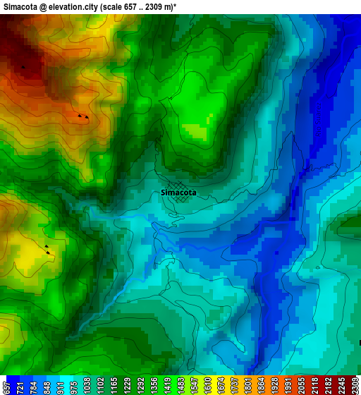
Below is the Elevation map of Simacota, which displays elevation range with different colors. Scale of the first map is from 657 to 2309 m (2156 to 7575 ft) with average elevation of 1181.2 meters (=3875 ft) [note 1]
These maps also provides idea of topography and contour of this city, they are displayed at different zoom levels. More info about maps, scale and edge coordinates you can find below images.
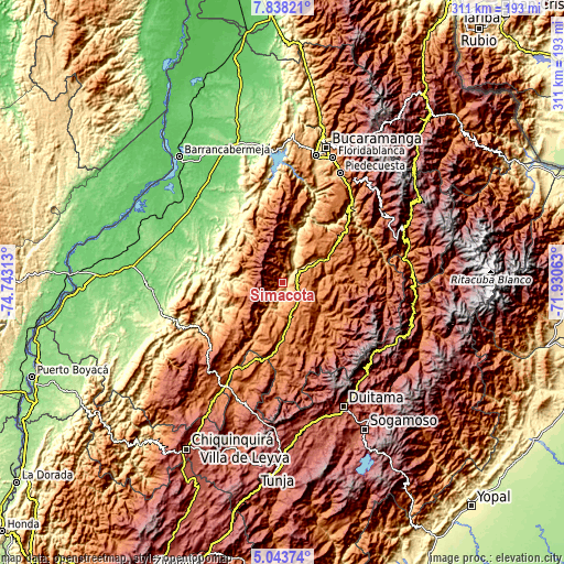
| \ | Map #1 | Topo.Map |
| Scale [m] | 657..2309 m | × |
| Scale [ft] | 2156..7575 ft | × |
| Average | 1181.2 m = 3875 ft | × |
| Width | 9.71 km = 6 mi | 310.7 km = 193.1 mi |
| Height | 9.71 km = 6 mi | 310.7 km = 193.1 mi |
| ↑Max Latitude | 6.486566° | 7.83821° |
| Latitude at center | 6.4429° | 6.4429° |
| ↓Min Latitude | 6.39923° | 5.04374° |
| ← Min Longitude | -73.380825° | -74.74313° |
| Longitude center | -73.33688° | -73.33688° |
| →Max Longitude | -73.292935° | -71.93063° |
Nearby cities:
Cities around Simacota sort by population:
• Socorro elevation 1234 m
8.9 km,  71°
71°
• Oiba 1421 m
20.3 km,  168°
168°
• Valle de San José 1243 m
21.4 km,  88°
88°
• Páramo 1406 m
18.7 km,  99°
99°
• Chima 1149 m
11.7 km,  200°
200°
• Pinchote 1200 m
20.6 km,  61°
61°
• Palmas del Socorro 1164 m
6.7 km,  126°
126°
• Hato 1347 m
11.6 km,  15°
15°
• Guapotá 1480 m
15.1 km, 172°
• Confines 1545 m
14.3 km, 132°
• Cabrera 1190 m
19.4 km,  30°
30°
• Palmar 907 m
11.6 km, 25°
Multilingual:
 En español:
Simacota elevación 1057 m.
 En France:
Simacota élévation 1057 m.
 Auf Deutsch:
Simacota höhe über dem Meeresspiegel ist 1057 m.

Sources and notes:
- [note 1] Map square and city borders are not equal. Map elevation data is calculated only from area inside that square.
- [src 1] Elevation data from geonames database provided with same terms of usage.
- [src 2] The elevation map of Simacota is generated using elevation data from NASA's 3 arcsec (90m) resolution SRTM data.
- [src 3] Base (background) map © OpenStreetMap contributors tiles are generated by Geofabrik and OpenTopoMap.
Copyright & License:
This Simacota Elevation Map is licensed under CC BY-SA. You may reuse any part from this page, if you give a proper credit by linking to this URL:
 More info on terms of use page.