Olaya Herrera elevation
Olaya Herrera (Nariño, Consaca), Colombia elevation is 1666 meters and Olaya Herrera elevation in feet is 5466 ft above sea level [src 1]. Olaya Herrera is a populated place (feature code) with elevation that is 517 meters (1696 ft) bigger than average city elevation in Colombia.
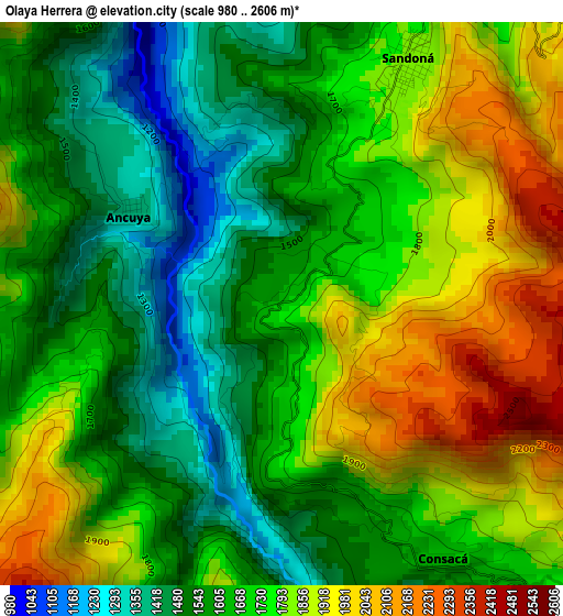
Below is the Elevation map of Olaya Herrera, which displays elevation range with different colors. Scale of the first map is from 980 to 2606 m (3215 to 8550 ft) with average elevation of 1707.7 meters (=5603 ft) [note 1]
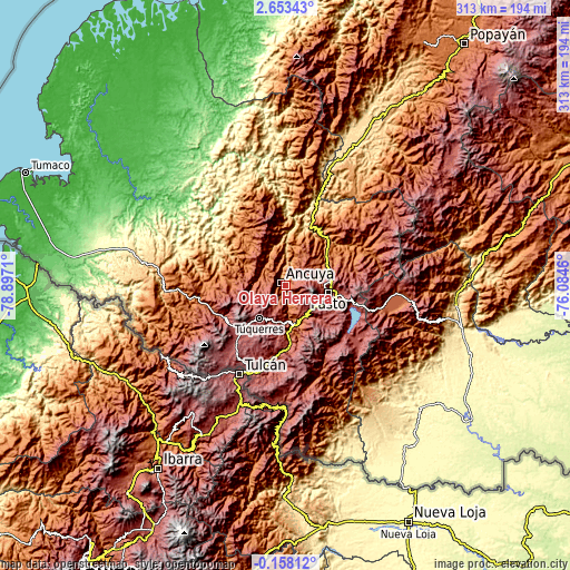
These maps also provides idea of topography and contour of this city, they are displayed at different zoom levels. More info about maps, scale and edge coordinates you can find below images.
| \ | Map #1 | Map #2 | Topo.Map |
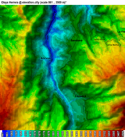
| Scale [m] | 980..2606 m | 861..3509 m | × |
| Scale [ft] | 3215..8550 ft | 2825..11512 ft | × |
| Average | 1707.7 m = 5603 ft | 2066.4 m = 6780 ft | × |
| Width | 9.77 km = 6.1 mi | 19.54 km = 12.1 mi | 312.6 km = 194.2 mi |
| Height | 9.77 km = 6.1 mi | 19.54 km = 12.1 mi | 312.6 km = 194.2 mi |
| ↑Max Latitude | 1.291965° | 1.335898° | 2.65343° |
| Latitude at center | 1.24803° | 1.24803° | 1.24803° |
| ↓Min Latitude | 1.204095° | 1.160159° | -0.15812° |
| ← Min Longitude | -77.534795° | -77.578741° | -78.8971° |
| Longitude center | -77.49085° | -77.49085° | -77.49085° |
| →Max Longitude | -77.446905° | -77.402959° | -76.0846° |
Nearby cities:
Cities around Olaya Herrera sort by population:
• Samaniego elevation 1459 m
15.4 km,  310°
310°
• Sandoná 1817 m
4.9 km,  29°
29°
• El Tambo 2419 m
20.9 km, 31°
• Guaitarilla 2627 m
14.5 km,  206°
206°
• Ancuya 1360 m
3.1 km,  303°
303°
• Linares 1706 m
12 km,  342°
342°
• Tangua 2402 m
20.1 km,  147°
147°
• Nariño 2347 m
15.6 km,  72°
72°
• La Florida 2185 m
11 km,  59°
59°
• Yacuanquer 2708 m
17.7 km, 146°
• Consacá 1660 m
5.3 km, 147°
• Providencia 2312 m
11.9 km,  265°
265°
Multilingual:
 En español:
Olaya Herrera elevación 1666 m.
 En France:
Olaya Herrera élévation 1666 m.
 Auf Deutsch:
Olaya Herrera höhe über dem Meeresspiegel ist 1666 m.

Sources and notes:
- [note 1] Map square and city borders are not equal. Map elevation data is calculated only from area inside that square.
- [src 1] Elevation data from geonames database provided with same terms of usage.
- [src 2] The elevation map of Olaya Herrera is generated using elevation data from NASA's 3 arcsec (90m) resolution SRTM data.
- [src 3] Base (background) map © OpenStreetMap contributors tiles are generated by Geofabrik and OpenTopoMap.
Copyright & License:
This Olaya Herrera Elevation Map is licensed under CC BY-SA. You may reuse any part from this page, if you give a proper credit by linking to this URL:
 More info on terms of use page.