Tangua elevation
Tangua (Nariño), Colombia elevation is 2402 meters and Tangua elevation in feet is 7881 ft above sea level [src 1]. Tangua is a seat of a second-order administrative division (feature code) with elevation that is 1253 meters (4111 ft) bigger than average city elevation in Colombia.
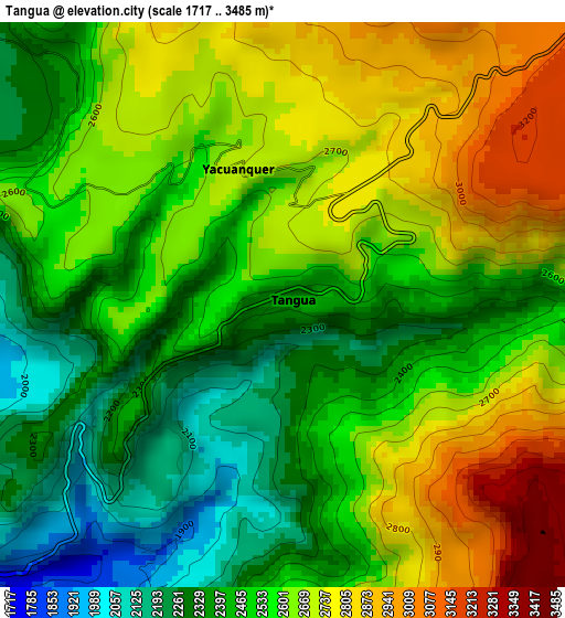
Below is the Elevation map of Tangua, which displays elevation range with different colors. Scale of the first map is from 1717 to 3485 m (5633 to 11434 ft) with average elevation of 2559.3 meters (=8397 ft) [note 1]
These maps also provides idea of topography and contour of this city, they are displayed at different zoom levels. More info about maps, scale and edge coordinates you can find below images.
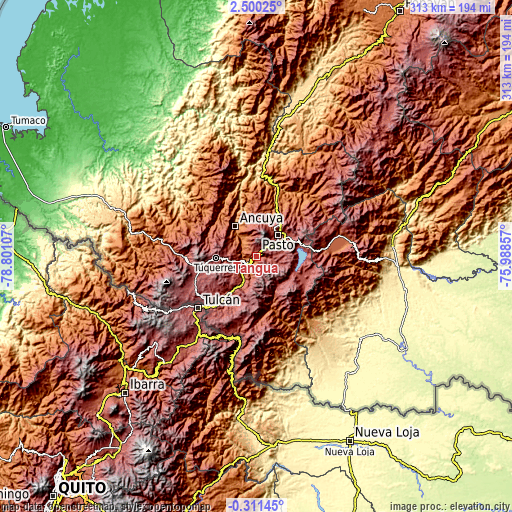
| \ | Map #1 | Topo.Map |
| Scale [m] | 1717..3485 m | × |
| Scale [ft] | 5633..11434 ft | × |
| Average | 2559.3 m = 8397 ft | × |
| Width | 9.77 km = 6.1 mi | 312.6 km = 194.2 mi |
| Height | 9.77 km = 6.1 mi | 312.7 km = 194.3 mi |
| ↑Max Latitude | 1.138667° | 2.50025° |
| Latitude at center | 1.09473° | 1.09473° |
| ↓Min Latitude | 1.050792° | -0.31145° |
| ← Min Longitude | -77.438765° | -78.80107° |
| Longitude center | -77.39482° | -77.39482° |
| →Max Longitude | -77.350875° | -75.98857° |
Nearby cities:
Cities around Tangua sort by population:
• Pasto elevation 2545 m
18.3 km,  43°
43°
• Olaya Herrera 1666 m
20.1 km,  327°
327°
• Guaitarilla 2627 m
17.5 km,  283°
283°
• Puerres 2577 m
18 km,  52°
52°
• Nariño 2347 m
22.1 km,  10°
10°
• La Florida 2185 m
22.7 km,  356°
356°
• Ospina 2862 m
19.4 km,  258°
258°
• Yacuanquer 2708 m
2.5 km,  341°
341°
• Funes 2042 m
12.1 km,  210°
210°
• Consacá 1660 m
14.8 km, 328°
• Iles 2694 m
19.7 km,  225°
225°
• Imués 2441 m
12.1 km,  248°
248°
Multilingual:
 En español:
Tangua elevación 2402 m.
 En France:
Tangua élévation 2402 m.


Sources and notes:
- [note 1] Map square and city borders are not equal. Map elevation data is calculated only from area inside that square.
- [src 1] Elevation data from geonames database provided with same terms of usage.
- [src 2] The elevation map of Tangua is generated using elevation data from NASA's 3 arcsec (90m) resolution SRTM data.
- [src 3] Base (background) map © OpenStreetMap contributors tiles are generated by Geofabrik and OpenTopoMap.
Copyright & License:
This Tangua Elevation Map is licensed under CC BY-SA. You may reuse any part from this page, if you give a proper credit by linking to this URL:
 More info on terms of use page.