Pijao elevation
Pijao (Quindío), Colombia elevation is 2010 meters and Pijao elevation in feet is 6594 ft above sea level [src 1]. Pijao is a seat of a second-order administrative division (feature code) with elevation that is 861 meters (2825 ft) bigger than average city elevation in Colombia.
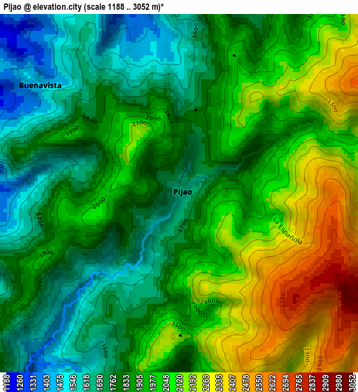
Below is the Elevation map of Pijao, which displays elevation range with different colors. Scale of the first map is from 1188 to 3052 m (3898 to 10013 ft) with average elevation of 1926.6 meters (=6321 ft) [note 1]
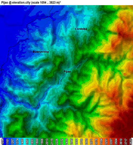
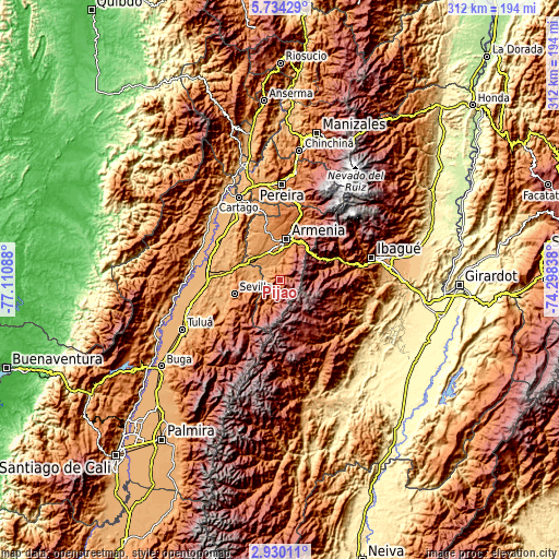
These maps also provides idea of topography and contour of this city, they are displayed at different zoom levels. More info about maps, scale and edge coordinates you can find below images.
| \ | Map #1 | Map #2 | Topo.Map |
| Scale [m] | 1188..3052 m | 1054..3823 m | × |
| Scale [ft] | 3898..10013 ft | 3458..12543 ft | × |
| Average | 1926.6 m = 6321 ft | 1998.6 m = 6557 ft | × |
| Width | 9.74 km = 6.1 mi | 19.49 km = 12.1 mi | 311.8 km = 193.7 mi |
| Height | 9.74 km = 6.1 mi | 19.49 km = 12.1 mi | 311.8 km = 193.7 mi |
| ↑Max Latitude | 4.377318° | 4.421134° | 5.73429° |
| Latitude at center | 4.3335° | 4.3335° | 4.3335° |
| ↓Min Latitude | 4.289679° | 4.245856° | 2.93011° |
| ← Min Longitude | -75.748575° | -75.792521° | -77.11088° |
| Longitude center | -75.70463° | -75.70463° | -75.70463° |
| →Max Longitude | -75.660685° | -75.616739° | -74.29838° |
Nearby cities:
Cities around Pijao sort by population:
• Armenia elevation 1480 m
22.4 km,  6°
6°
• Calarcá 1537 m
22.9 km,  17°
17°
• Sevilla 1617 m
26.2 km,  252°
252°
• Montenegro 1297 m
26.4 km,  348°
348°
• Caicedonia 1165 m
13.5 km,  269°
269°
• La Tebaida 1191 m
16.1 km,  325°
325°
• Anaime 1818 m
29.6 km,  76°
76°
• Circasia 1772 m
32.6 km, 13°
• Génova 1228 m
7.1 km, 254°
• Córdoba 1771 m
6.7 km, 16°
• Buenavista 1514 m
4.8 km,  307°
307°
• Génova 1426 m
16.8 km,  213°
213°
Multilingual:
 En español:
Pijao elevación 2010 m.
 En France:
Pijao élévation 2010 m.


Sources and notes:
- [note 1] Map square and city borders are not equal. Map elevation data is calculated only from area inside that square.
- [src 1] Elevation data from geonames database provided with same terms of usage.
- [src 2] The elevation map of Pijao is generated using elevation data from NASA's 3 arcsec (90m) resolution SRTM data.
- [src 3] Base (background) map © OpenStreetMap contributors tiles are generated by Geofabrik and OpenTopoMap.
Copyright & License:
This Pijao Elevation Map is licensed under CC BY-SA. You may reuse any part from this page, if you give a proper credit by linking to this URL:
 More info on terms of use page.