Puerto Boyacá elevation
Puerto Boyacá (Boyacá), Colombia elevation is 142 meters and Puerto Boyacá elevation in feet is 466 ft above sea level [src 1]. Puerto Boyacá is a seat of a second-order administrative division (feature code) with elevation that is 1007 meters (3304 ft) smaller than average city elevation in Colombia.
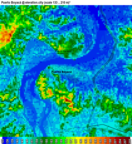
Below is the Elevation map of Puerto Boyacá, which displays elevation range with different colors. Scale of the first map is from 133 to 210 m (436 to 689 ft) with average elevation of 147.9 meters (=485 ft) [note 1]
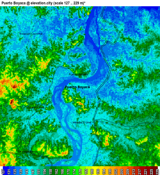
These maps also provides idea of topography and contour of this city, they are displayed at different zoom levels. More info about maps, scale and edge coordinates you can find below images.
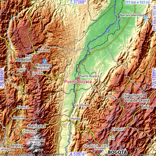
| \ | Map #1 | Map #2 | Topo.Map |
| Scale [m] | 133..210 m | 127..229 m | × |
| Scale [ft] | 436..689 ft | 417..751 ft | × |
| Average | 147.9 m = 485 ft | 152.2 m = 499 ft | × |
| Width | 9.72 km = 6 mi | 19.44 km = 12.1 mi | 311 km = 193.2 mi |
| Height | 9.72 km = 6 mi | 19.44 km = 12.1 mi | 311 km = 193.2 mi |
| ↑Max Latitude | 6.019705° | 6.063406° | 7.37268° |
| Latitude at center | 5.976° | 5.976° | 5.976° |
| ↓Min Latitude | 5.932292° | 5.88858° | 4.57574° |
| ← Min Longitude | -74.629105° | -74.673051° | -75.99141° |
| Longitude center | -74.58516° | -74.58516° | -74.58516° |
| →Max Longitude | -74.541215° | -74.497269° | -73.17891° |
Nearby cities:
Cities around Puerto Boyacá sort by population:
• La Dorada elevation 176 m
59.4 km,  188°
188°
• Puerto Berrío 110 m
60.7 km,  19°
19°
• Puerto Salgar 177 m
57.5 km, 187°
• San Carlos 989 m
50.9 km,  297°
297°
• San Rafael 994 m
60.2 km,  305°
305°
• Norcasia 621 m
55.8 km,  216°
216°
• Puerto Triunfo 154 m
13 km,  208°
208°
• Otanche 1075 m
57 km,  128°
128°
• Caracolí 643 m
51.8 km,  338°
338°
• La Victoria 1450 m
63.2 km,  142°
142°
• San Francisco 1276 m
57.1 km,  268°
268°
• San Luis 1061 m
45.8 km,  279°
279°
Multilingual:
 En español:
Puerto Boyacá elevación 142 m.
 En France:
Puerto Boyacá élévation 142 m.
 Auf Deutsch:
Puerto Boyacá höhe über dem Meeresspiegel ist 142 m.

Sources and notes:
- [note 1] Map square and city borders are not equal. Map elevation data is calculated only from area inside that square.
- [src 1] Elevation data from geonames database provided with same terms of usage.
- [src 2] The elevation map of Puerto Boyacá is generated using elevation data from NASA's 3 arcsec (90m) resolution SRTM data.
- [src 3] Base (background) map © OpenStreetMap contributors tiles are generated by Geofabrik and OpenTopoMap.
Copyright & License:
This Puerto Boyacá Elevation Map is licensed under CC BY-SA. You may reuse any part from this page, if you give a proper credit by linking to this URL:
 More info on terms of use page.