San Rafael elevation
San Rafael (Antioquia), Colombia elevation is 994 meters and San Rafael elevation in feet is 3261 ft above sea level [src 1]. San Rafael is a seat of a second-order administrative division (feature code) with elevation that is 155 meters (509 ft) smaller than average city elevation in Colombia.
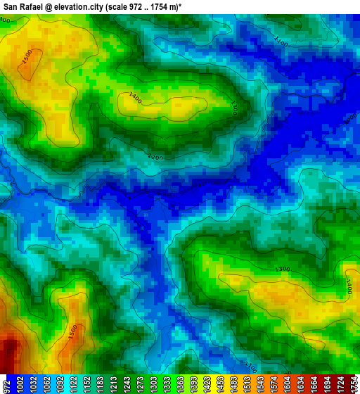
Below is the Elevation map of San Rafael, which displays elevation range with different colors. Scale of the first map is from 972 to 1754 m (3189 to 5755 ft) with average elevation of 1206.7 meters (=3959 ft) [note 1]
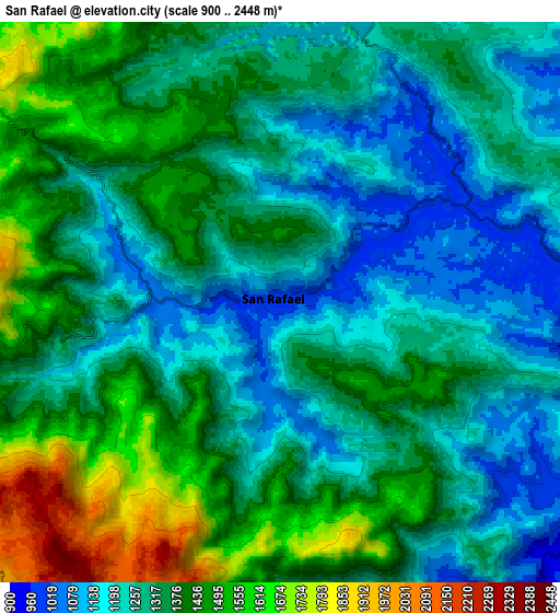
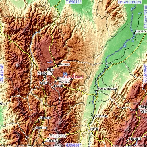
These maps also provides idea of topography and contour of this city, they are displayed at different zoom levels. More info about maps, scale and edge coordinates you can find below images.
| \ | Map #1 | Map #2 | Topo.Map |
| Scale [m] | 972..1754 m | 900..2448 m | × |
| Scale [ft] | 3189..5755 ft | 2953..8031 ft | × |
| Average | 1206.7 m = 3959 ft | 1339.1 m = 4393 ft | × |
| Width | 9.71 km = 6 mi | 19.43 km = 12.1 mi | 310.8 km = 193.1 mi |
| Height | 9.71 km = 6 mi | 19.43 km = 12.1 mi | 310.8 km = 193.1 mi |
| ↑Max Latitude | 6.338039° | 6.381713° | 7.69012° |
| Latitude at center | 6.29436° | 6.29436° | 6.29436° |
| ↓Min Latitude | 6.250678° | 6.206992° | 4.89484° |
| ← Min Longitude | -75.069835° | -75.113781° | -76.43214° |
| Longitude center | -75.02589° | -75.02589° | -75.02589° |
| →Max Longitude | -74.981945° | -74.937999° | -73.61964° |
Nearby cities:
Cities around San Rafael sort by population:
• Santuario elevation 2119 m
31.5 km,  236°
236°
• Cisneros 1042 m
28 km,  345°
345°
• San Carlos 989 m
12.4 km,  163°
163°
• Granada 2081 m
24.3 km,  226°
226°
• San Roque 1426 m
21.2 km,  1°
1°
• Guatapé 1889 m
16.6 km,  246°
246°
• Cocorná 1304 m
31.7 km,  213°
213°
• Caracolí 643 m
32.3 km,  66°
66°
• Santo Domingo 1968 m
25.1 km,  322°
322°
• Concepción 1832 m
28 km,  293°
293°
• San Luis 1061 m
28.1 km,  172°
172°
• Alejandría 1650 m
15.7 km,  306°
306°
Multilingual:
 En español:
San Rafael elevación 994 m.
 En France:
San Rafael élévation 994 m.
 Auf Deutsch:
San Rafael höhe über dem Meeresspiegel ist 994 m.

Sources and notes:
- [note 1] Map square and city borders are not equal. Map elevation data is calculated only from area inside that square.
- [src 1] Elevation data from geonames database provided with same terms of usage.
- [src 2] The elevation map of San Rafael is generated using elevation data from NASA's 3 arcsec (90m) resolution SRTM data.
- [src 3] Base (background) map © OpenStreetMap contributors tiles are generated by Geofabrik and OpenTopoMap.
Copyright & License:
This San Rafael Elevation Map is licensed under CC BY-SA. You may reuse any part from this page, if you give a proper credit by linking to this URL:
 More info on terms of use page.