Xujiaba elevation
Xujiaba (Guizhou), China elevation is 589 meters and Xujiaba elevation in feet is 1932 ft above sea level [src 1]. Xujiaba is a populated place (feature code) with elevation that is 31 meters (102 ft) bigger than average city elevation in China.
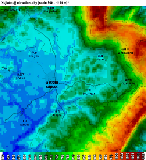
Below is the Elevation map of Xujiaba, which displays elevation range with different colors. Scale of the first map is from 500 to 1119 m (1640 to 3671 ft) with average elevation of 696.4 meters (=2285 ft) [note 1]
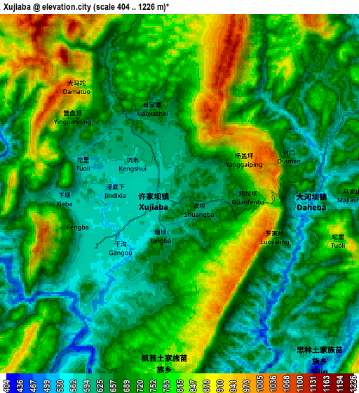
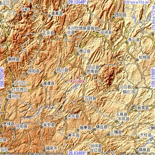
These maps also provides idea of topography and contour of this city, they are displayed at different zoom levels. More info about maps, scale and edge coordinates you can find below images.
| \ | Map #1 | Map #2 | Topo.Map |
| Scale [m] | 500..1119 m | 404..1226 m | × |
| Scale [ft] | 1640..3671 ft | 1325..4022 ft | × |
| Average | 696.4 m = 2285 ft | 719.4 m = 2360 ft | × |
| Width | 8.64 km = 5.4 mi | 17.28 km = 10.7 mi | 276.4 km = 171.7 mi |
| Height | 8.64 km = 5.4 mi | 17.28 km = 10.7 mi | 276.4 km = 171.7 mi |
| ↑Max Latitude | 27.923556° | 27.962378° | 29.12049° |
| Latitude at center | 27.88472° | 27.88472° | 27.88472° |
| ↓Min Latitude | 27.84587° | 27.807006° | 26.63469° |
| ← Min Longitude | 108.069665° | 108.025719° | 106.70736° |
| Longitude center | 108.11361° | 108.11361° | 108.11361° |
| →Max Longitude | 108.157555° | 108.201501° | 109.51986° |
Nearby cities:
Cities around Xujiaba sort by population:
• Shiqian elevation 477 m
41.8 km,  164°
164°
• Qinglang 398 m
104.3 km,  144°
144°
• Zhujiachang 508 m
100.2 km,  125°
125°
• Chadian 698 m
105.8 km,  108°
108°
• Dabachang 571 m
27.6 km,  124°
124°
• Bahuang 308 m
90.9 km,  101°
101°
• Fengyi 675 m
99.5 km,  318°
318°
• Siyang 405 m
97.3 km, 140°
• Heping 292 m
83.4 km,  26°
26°
• Duru 649 m
74.6 km,  342°
342°
• Qinglong 519 m
42.1 km,  359°
359°
• Eling 460 m
31 km,  65°
65°
Multilingual:
 En español:
Xujiaba elevación 589 m.
 En France:
Xujiaba élévation 589 m.


Sources and notes:
- [note 1] Map square and city borders are not equal. Map elevation data is calculated only from area inside that square.
- [src 1] Elevation data from geonames database provided with same terms of usage.
- [src 2] The elevation map of Xujiaba is generated using elevation data from NASA's 3 arcsec (90m) resolution SRTM data.
- [src 3] Base (background) map © OpenStreetMap contributors tiles are generated by Geofabrik and OpenTopoMap.
Copyright & License:
This Xujiaba Elevation Map is licensed under CC BY-SA. You may reuse any part from this page, if you give a proper credit by linking to this URL:
 More info on terms of use page.