Korla elevation
Korla (Xinjiang), China elevation is 945 meters and Korla elevation in feet is 3100 ft above sea level [src 1]. Korla is a seat of a third-order administrative division (feature code) with elevation that is 387 meters (1270 ft) bigger than average city elevation in China.
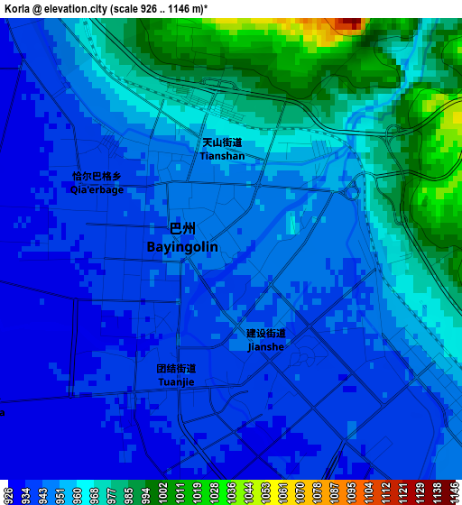
Below is the Elevation map of Korla, which displays elevation range with different colors. Scale of the first map is from 926 to 1146 m (3038 to 3760 ft) with average elevation of 954.7 meters (=3132 ft) [note 1]
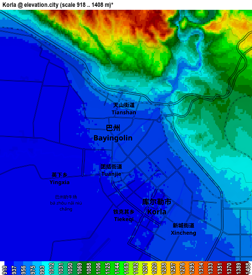
These maps also provides idea of topography and contour of this city, they are displayed at different zoom levels. More info about maps, scale and edge coordinates you can find below images.
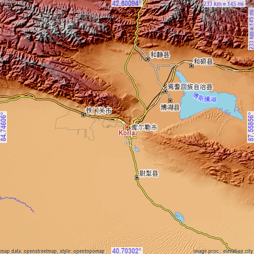
| \ | Map #1 | Map #2 | Topo.Map |
| Scale [m] | 926..1146 m | 918..1408 m | × |
| Scale [ft] | 3038..3760 ft | 3012..4619 ft | × |
| Average | 954.7 m = 3132 ft | 994 m = 3261 ft | × |
| Width | 7.29 km = 4.5 mi | 14.58 km = 9.1 mi | 233.3 km = 145 mi |
| Height | 7.29 km = 4.5 mi | 14.58 km = 9.1 mi | 233.3 km = 145 mi |
| ↑Max Latitude | 41.793322° | 41.826077° | 42.80094° |
| Latitude at center | 41.76055° | 41.76055° | 41.76055° |
| ↓Min Latitude | 41.727761° | 41.694956° | 40.70302° |
| ← Min Longitude | 86.108365° | 86.064419° | 84.74606° |
| Longitude center | 86.15231° | 86.15231° | 86.15231° |
| →Max Longitude | 86.196255° | 86.240201° | 87.55856° |
Nearby cities:
Cities around Korla sort by population:
• Sishilichengzi elevation 1057 m
35 km,  50°
50°
• Baluntaicun 1792 m
101.9 km,  7°
7°
• Xingfulu 916 m
255.4 km,  28°
28°
• Yangzi Jianglu 912 m
252.6 km, 27°
• Dabancheng 1107 m
251.1 km,  44°
44°
• Toksun 5 m
234.8 km,  60°
60°
• Luntai 972 m
158.2 km,  270°
270°
• Hoxut 1085 m
80.4 km, 46°
• Hejing 1109 m
64.7 km,  17°
17°
• Yuli 890 m
47.9 km,  169°
169°
• Yanqi 1059 m
47.9 km, 45°
• Bohu 1054 m
46.2 km, 57°
Multilingual:
 En español:
Korla elevación 945 m.
 En France:
Korla élévation 945 m.


Sources and notes:
- [note 1] Map square and city borders are not equal. Map elevation data is calculated only from area inside that square.
- [src 1] Elevation data from geonames database provided with same terms of usage.
- [src 2] The elevation map of Korla is generated using elevation data from NASA's 3 arcsec (90m) resolution SRTM data.
- [src 3] Base (background) map © OpenStreetMap contributors tiles are generated by Geofabrik and OpenTopoMap.
Copyright & License:
This Korla Elevation Map is licensed under CC BY-SA. You may reuse any part from this page, if you give a proper credit by linking to this URL:
 More info on terms of use page.