Hotan elevation
Hotan (Xinjiang), China elevation is 1384 meters and Hotan elevation in feet is 4541 ft above sea level [src 1]. Hotan is a seat of a third-order administrative division (feature code) with elevation that is 826 meters (2710 ft) bigger than average city elevation in China.
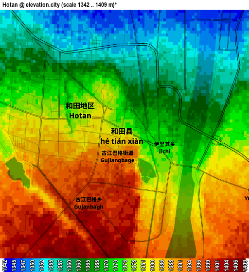
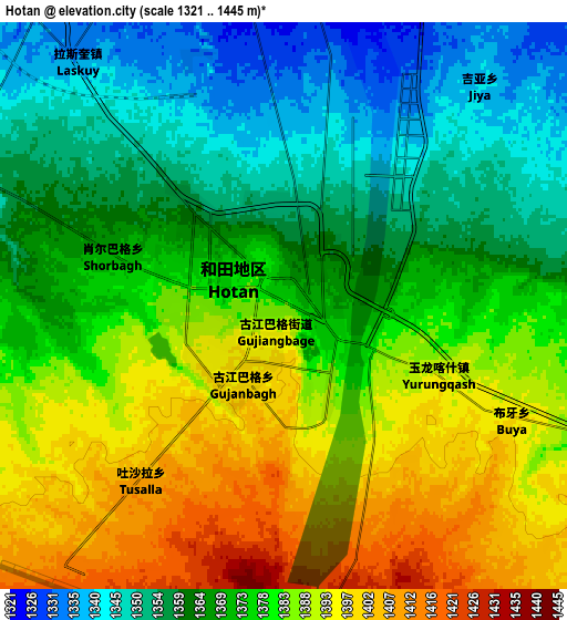
Below is the Elevation map of Hotan, which displays elevation range with different colors. Scale of the first map is from 1342 to 1409 m (4403 to 4623 ft) with average elevation of 1376.6 meters (=4516 ft) [note 1]
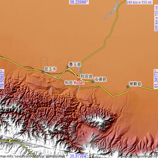
These maps also provides idea of topography and contour of this city, they are displayed at different zoom levels. More info about maps, scale and edge coordinates you can find below images.
| \ | Map #1 | Map #2 | Topo.Map |
| Scale [m] | 1342..1409 m | 1321..1445 m | × |
| Scale [ft] | 4403..4623 ft | 4334..4741 ft | × |
| Average | 1376.6 m = 4516 ft | 1374.7 m = 4510 ft | × |
| Width | 7.79 km = 4.8 mi | 15.59 km = 9.7 mi | 249.4 km = 155 mi |
| Height | 7.79 km = 4.8 mi | 15.59 km = 9.7 mi | 249.4 km = 155 mi |
| ↑Max Latitude | 37.142538° | 37.177561° | 38.22066° |
| Latitude at center | 37.1075° | 37.1075° | 37.1075° |
| ↓Min Latitude | 37.072445° | 37.037374° | 35.97774° |
| ← Min Longitude | 79.891535° | 79.847589° | 78.52923° |
| Longitude center | 79.93548° | 79.93548° | 79.93548° |
| →Max Longitude | 79.979425° | 80.023371° | 81.34173° |
Nearby cities:
Cities around Hotan sort by population:
• Shache elevation 1236 m
278 km,  301°
301°
• Zangguy 1487 m
105.4 km,  280°
280°
• Yopurga 1208 m
364.7 km,  310°
310°
• Tumxuk 1086 m
316.4 km,  346°
346°
• Zepu 1273 m
263.6 km, 297°
• Niya 1417 m
244.3 km,  91°
91°
• Guma 1374 m
156.8 km,  291°
291°
• Mugala 1432 m
156.4 km,  100°
100°
• Qira 1373 m
77.5 km, 96°
• Karakax 1328 m
25.4 km,  316°
316°
• Lop 1347 m
22.2 km, 99°
• Nu’erbage 1379 m
2.3 km, 286°
Multilingual:
 En español:
Ciudad de Jotán elevación 1384 m.
 En France:
Khotan élévation 1384 m.


Sources and notes:
- [note 1] Map square and city borders are not equal. Map elevation data is calculated only from area inside that square.
- [src 1] Elevation data from geonames database provided with same terms of usage.
- [src 2] The elevation map of Hotan is generated using elevation data from NASA's 3 arcsec (90m) resolution SRTM data.
- [src 3] Base (background) map © OpenStreetMap contributors tiles are generated by Geofabrik and OpenTopoMap.
Copyright & License:
This Hotan Elevation Map is licensed under CC BY-SA. You may reuse any part from this page, if you give a proper credit by linking to this URL:
 More info on terms of use page.