Kashgar elevation
Kashgar (Xinjiang), China elevation is 1297 meters and Kashgar elevation in feet is 4255 ft above sea level [src 1]. Kashgar is a seat of a second-order administrative division (feature code) with elevation that is 739 meters (2425 ft) bigger than average city elevation in China.
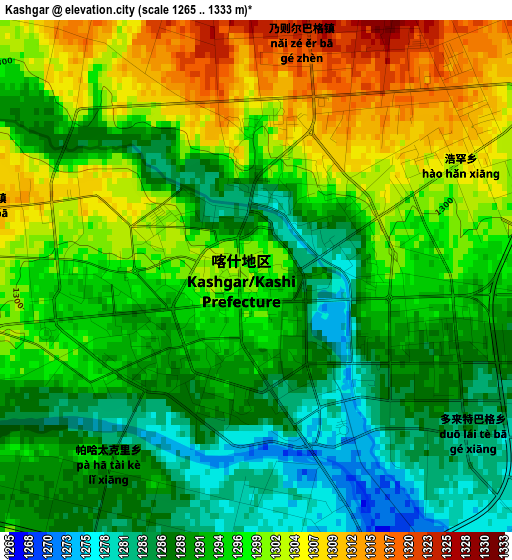
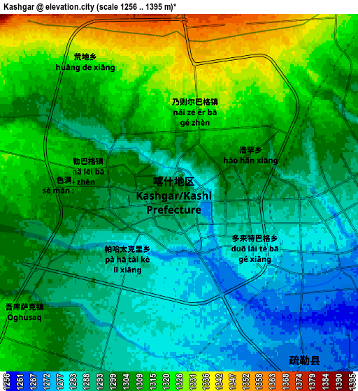
Below is the Elevation map of Kashgar, which displays elevation range with different colors. Scale of the first map is from 1265 to 1333 m (4150 to 4373 ft) with average elevation of 1295 meters (=4249 ft) [note 1]
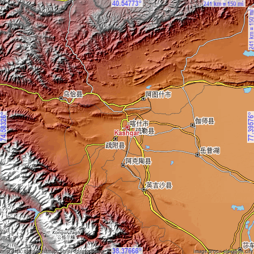
These maps also provides idea of topography and contour of this city, they are displayed at different zoom levels. More info about maps, scale and edge coordinates you can find below images.
| \ | Map #1 | Map #2 | Topo.Map |
| Scale [m] | 1265..1333 m | 1256..1395 m | × |
| Scale [ft] | 4150..4373 ft | 4121..4577 ft | × |
| Average | 1295 m = 4249 ft | 1302.3 m = 4273 ft | × |
| Width | 7.54 km = 4.7 mi | 15.09 km = 9.4 mi | 241.4 km = 150 mi |
| Height | 7.54 km = 4.7 mi | 15.09 km = 9.4 mi | 241.4 km = 150 mi |
| ↑Max Latitude | 39.504575° | 39.538474° | 40.54773° |
| Latitude at center | 39.47066° | 39.47066° | 39.47066° |
| ↓Min Latitude | 39.436728° | 39.40278° | 38.37666° |
| ← Min Longitude | 75.945565° | 75.901619° | 74.58326° |
| Longitude center | 75.98951° | 75.98951° | 75.98951° |
| →Max Longitude | 76.033455° | 76.077401° | 77.39576° |
Nearby cities:
Cities around Kashgar sort by population:
• Shache elevation 1236 m
159.5 km,  137°
137°
• Zangguy 1487 m
343.1 km, 135°
• Wushi 1619 m
331.9 km,  55°
55°
• Kalpin 1152 m
287.2 km,  65°
65°
• Guma 1374 m
286.7 km, 135°
• Tumxuk 1086 m
266.6 km,  80°
80°
• Akqi 1986 m
264.9 km,  51°
51°
• Zepu 1273 m
180.6 km, 142°
• Yopurga 1208 m
71.4 km,  111°
111°
• Jiashi 1210 m
64.7 km,  87°
87°
• Shule 1269 m
9.2 km,  145°
145°
Multilingual:
 En español:
Kasgar elevación 1297 m.
 En France:
Kachgar élévation 1297 m.
 Auf Deutsch:
Kaschgar höhe über dem Meeresspiegel ist 1297 m.

Sources and notes:
- [note 1] Map square and city borders are not equal. Map elevation data is calculated only from area inside that square.
- [src 1] Elevation data from geonames database provided with same terms of usage.
- [src 2] The elevation map of Kashgar is generated using elevation data from NASA's 3 arcsec (90m) resolution SRTM data.
- [src 3] Base (background) map © OpenStreetMap contributors tiles are generated by Geofabrik and OpenTopoMap.
Copyright & License:
This Kashgar Elevation Map is licensed under CC BY-SA. You may reuse any part from this page, if you give a proper credit by linking to this URL:
 More info on terms of use page.