Laojunmiao elevation
Laojunmiao (Gansu), China elevation is 2026 meters and Laojunmiao elevation in feet is 6647 ft above sea level [src 1]. Laojunmiao is a seat of a fourth-order administrative division (feature code) with elevation that is 1468 meters (4816 ft) bigger than average city elevation in China.
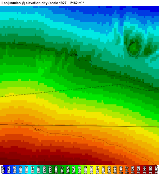
Below is the Elevation map of Laojunmiao, which displays elevation range with different colors. Scale of the first map is from 1927 to 2162 m (6322 to 7093 ft) with average elevation of 2037 meters (=6683 ft) [note 1]
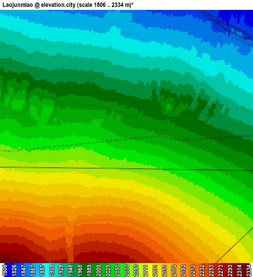
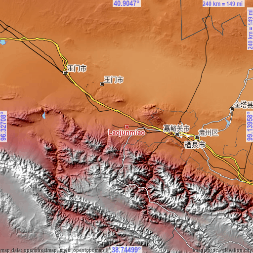
These maps also provides idea of topography and contour of this city, they are displayed at different zoom levels. More info about maps, scale and edge coordinates you can find below images.
| \ | Map #1 | Map #2 | Topo.Map |
| Scale [m] | 1927..2162 m | 1806..2334 m | × |
| Scale [ft] | 6322..7093 ft | 5925..7657 ft | × |
| Average | 2037 m = 6683 ft | 2034.7 m = 6676 ft | × |
| Width | 7.5 km = 4.7 mi | 15.01 km = 9.3 mi | 240.1 km = 149.2 mi |
| Height | 7.5 km = 4.7 mi | 15.01 km = 9.3 mi | 240.1 km = 149.2 mi |
| ↑Max Latitude | 39.867068° | 39.900789° | 40.9047° |
| Latitude at center | 39.83333° | 39.83333° | 39.83333° |
| ↓Min Latitude | 39.799576° | 39.765805° | 38.74499° |
| ← Min Longitude | 97.689385° | 97.645439° | 96.32708° |
| Longitude center | 97.73333° | 97.73333° | 97.73333° |
| →Max Longitude | 97.777275° | 97.821221° | 99.13958° |
Nearby cities:
Cities around Laojunmiao sort by population:
• Jiayuguan elevation 1635 m
47.3 km,  92°
92°
• Zhangye 1481 m
254.1 km,  113°
113°
• Jiuquan 1464 m
67.7 km,  98°
98°
• Shazhou 1144 m
263.8 km,  277°
277°
• Nanjie 1468 m
254.8 km, 112°
• Dangchengwan 3277 m
233.4 km,  260°
260°
• Shahe 1448 m
223.5 km, 110°
• Hongwansi 2545 m
195.1 km,  124°
124°
• Gaotai Chengguanzhen 1357 m
185.2 km, 107°
• Yuanquan 1178 m
180.2 km,  294°
294°
• Jinta 1280 m
98.1 km,  80°
80°
• Yumen 1461 m
67.6 km,  317°
317°
Multilingual:
 En español:
Laojunmiao elevación 2026 m.
 En France:
Laojunmiao élévation 2026 m.
 Auf Deutsch:
Laojunmiao höhe über dem Meeresspiegel ist 2026 m.

Sources and notes:
- [note 1] Map square and city borders are not equal. Map elevation data is calculated only from area inside that square.
- [src 1] Elevation data from geonames database provided with same terms of usage.
- [src 2] The elevation map of Laojunmiao is generated using elevation data from NASA's 3 arcsec (90m) resolution SRTM data.
- [src 3] Base (background) map © OpenStreetMap contributors tiles are generated by Geofabrik and OpenTopoMap.
Copyright & License:
This Laojunmiao Elevation Map is licensed under CC BY-SA. You may reuse any part from this page, if you give a proper credit by linking to this URL:
 More info on terms of use page.