Pubu elevation
Pubu (Tibet), China elevation is 4717 meters and Pubu elevation in feet is 15476 ft above sea level [src 1]. Pubu is a seat of a third-order administrative division (feature code) with elevation that is 4159 meters (13645 ft) bigger than average city elevation in China.
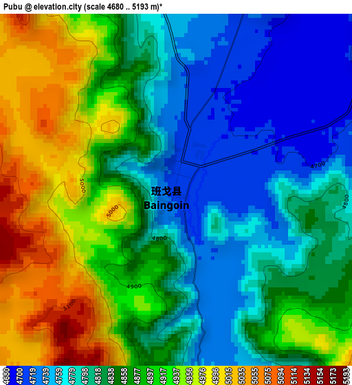
Below is the Elevation map of Pubu, which displays elevation range with different colors. Scale of the first map is from 4680 to 5193 m (15354 to 17037 ft) with average elevation of 4856.7 meters (=15934 ft) [note 1]
These maps also provides idea of topography and contour of this city, they are displayed at different zoom levels. More info about maps, scale and edge coordinates you can find below images.
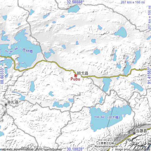
| \ | Map #1 | Topo.Map |
| Scale [m] | 4680..5193 m | × |
| Scale [ft] | 15354..17037 ft | × |
| Average | 4856.7 m = 15934 ft | × |
| Width | 8.34 km = 5.2 mi | 266.9 km = 165.8 mi |
| Height | 8.34 km = 5.2 mi | 266.9 km = 165.8 mi |
| ↑Max Latitude | 31.433754° | 32.58888° |
| Latitude at center | 31.39625° | 31.39625° |
| ↓Min Latitude | 31.358731° | 30.18828° |
| ← Min Longitude | 89.965635° | 88.60333° |
| Longitude center | 90.00958° | 90.00958° |
| →Max Longitude | 90.053525° | 91.41583° |
Nearby cities:
Cities around Pubu sort by population:
• Lhasa elevation 3651 m
220.5 km,  151°
151°
• Dêqên 3974 m
173.3 km,  156°
156°
• Nagqu 4512 m
194.5 km,  87°
87°
• Qiangqinxue 5381 m
237 km,  182°
182°
• Nierong 4607 m
230.4 km,  69°
69°
• Renwu 4690 m
221.2 km,  205°
205°
• Jibenggang 3654 m
220.9 km, 151°
• Segong 4680 m
219 km, 65°
• Namling 4004 m
209.4 km,  204°
204°
• Nagqu 4536 m
189.2 km, 89°
• Pagnag 4687 m
185.4 km,  58°
58°
• Jiajuedibu 4679 m
140.7 km,  248°
248°
Multilingual:
 En español:
Pubu elevación 4717 m.
 En France:
Pubu élévation 4717 m.


Sources and notes:
- [note 1] Map square and city borders are not equal. Map elevation data is calculated only from area inside that square.
- [src 1] Elevation data from geonames database provided with same terms of usage.
- [src 2] The elevation map of Pubu is generated using elevation data from NASA's 3 arcsec (90m) resolution SRTM data.
- [src 3] Base (background) map © OpenStreetMap contributors tiles are generated by Geofabrik and OpenTopoMap.
Copyright & License:
This Pubu Elevation Map is licensed under CC BY-SA. You may reuse any part from this page, if you give a proper credit by linking to this URL:
 More info on terms of use page.