Saga elevation
Saga (Tibet), China elevation is 4475 meters and Saga elevation in feet is 14682 ft above sea level [src 1]. Saga is a populated place (feature code) with elevation that is 3917 meters (12851 ft) bigger than average city elevation in China.
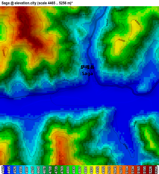
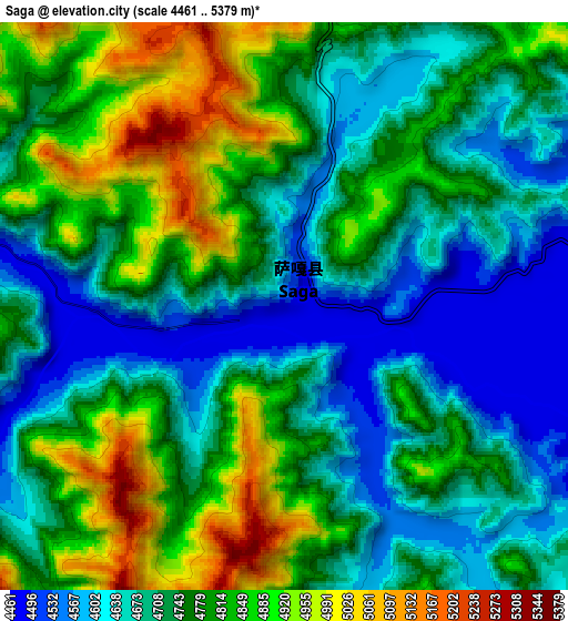
Below is the Elevation map of Saga, which displays elevation range with different colors. Scale of the first map is from 4465 to 5256 m (14649 to 17244 ft) with average elevation of 4691.7 meters (=15393 ft) [note 1]
These maps also provides idea of topography and contour of this city, they are displayed at different zoom levels. More info about maps, scale and edge coordinates you can find below images.
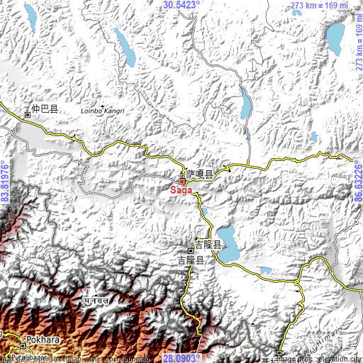
| \ | Map #1 | Map #2 | Topo.Map |
| Scale [m] | 4465..5256 m | 4461..5379 m | × |
| Scale [ft] | 14649..17244 ft | 14636..17648 ft | × |
| Average | 4691.7 m = 15393 ft | 4751.4 m = 15589 ft | × |
| Width | 8.52 km = 5.3 mi | 17.04 km = 10.6 mi | 272.6 km = 169.4 mi |
| Height | 8.52 km = 5.3 mi | 17.04 km = 10.6 mi | 272.6 km = 169.4 mi |
| ↑Max Latitude | 29.361977° | 29.40027° | 30.5423° |
| Latitude at center | 29.32367° | 29.32367° | 29.32367° |
| ↓Min Latitude | 29.285348° | 29.247012° | 28.0903° |
| ← Min Longitude | 85.182065° | 85.138119° | 83.81976° |
| Longitude center | 85.22601° | 85.22601° | 85.22601° |
| →Max Longitude | 85.269955° | 85.313901° | 86.63226° |
Nearby cities:
Cities around Saga sort by population:
• Luring elevation 4500 m
341.6 km,  343°
343°
• Gangba 4594 m
339.7 km,  111°
111°
• Jiding 3898 m
293.1 km,  89°
89°
• Sajia 4643 m
278 km,  99°
99°
• Gyangkar 4193 m
270.9 km, 112°
• Quxar 3999 m
236.6 km, 96°
• Maindong 4899 m
224.2 km,  4°
4°
• Xêgar 4476 m
196.3 km, 113°
• Ngamring 4721 m
188.5 km, 93°
• Chongdui 4063 m
149.1 km,  151°
151°
• Zhadong 4559 m
108.8 km,  289°
289°
• Zongga 5622 m
36.1 km,  176°
176°
Multilingual:
 En español:
Saga elevación 4475 m.
 En France:
Saga élévation 4475 m.


Sources and notes:
- [note 1] Map square and city borders are not equal. Map elevation data is calculated only from area inside that square.
- [src 1] Elevation data from geonames database provided with same terms of usage.
- [src 2] The elevation map of Saga is generated using elevation data from NASA's 3 arcsec (90m) resolution SRTM data.
- [src 3] Base (background) map © OpenStreetMap contributors tiles are generated by Geofabrik and OpenTopoMap.
Copyright & License:
This Saga Elevation Map is licensed under CC BY-SA. You may reuse any part from this page, if you give a proper credit by linking to this URL:
 More info on terms of use page.