Chengzihe elevation
Chengzihe (Heilongjiang), China elevation is 210 meters and Chengzihe elevation in feet is 689 ft above sea level [src 1]. Chengzihe is a populated place (feature code) with elevation that is 348 meters (1142 ft) smaller than average city elevation in China.
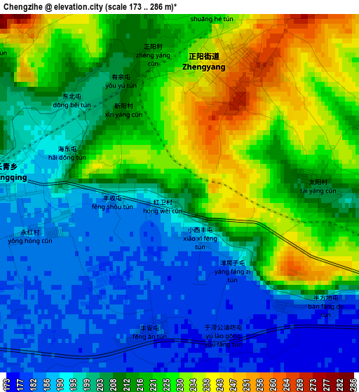
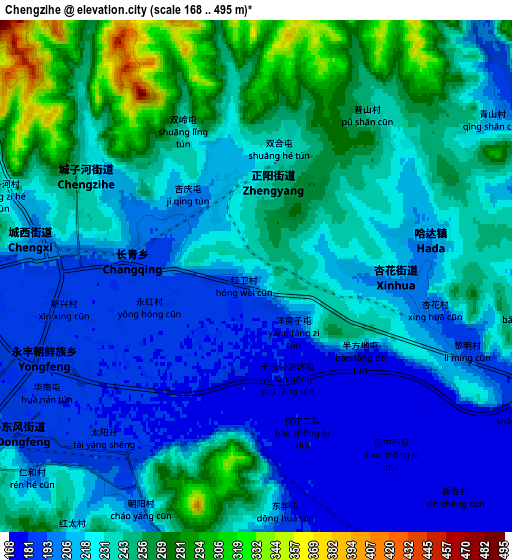
Below is the Elevation map of Chengzihe, which displays elevation range with different colors. Scale of the first map is from 173 to 286 m (568 to 938 ft) with average elevation of 209.7 meters (=688 ft) [note 1]
These maps also provides idea of topography and contour of this city, they are displayed at different zoom levels. More info about maps, scale and edge coordinates you can find below images.
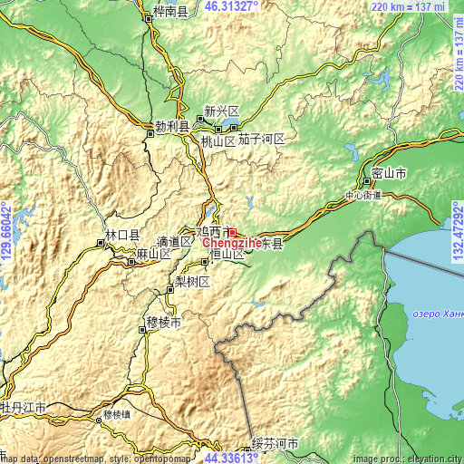
| \ | Map #1 | Map #2 | Topo.Map |
| Scale [m] | 173..286 m | 168..495 m | × |
| Scale [ft] | 568..938 ft | 551..1624 ft | × |
| Average | 209.7 m = 688 ft | 228.6 m = 750 ft | × |
| Width | 6.87 km = 4.3 mi | 13.74 km = 8.5 mi | 219.8 km = 136.6 mi |
| Height | 6.87 km = 4.3 mi | 13.74 km = 8.5 mi | 219.8 km = 136.6 mi |
| ↑Max Latitude | 45.364214° | 45.395082° | 46.31327° |
| Latitude at center | 45.33333° | 45.33333° | 45.33333° |
| ↓Min Latitude | 45.302429° | 45.271511° | 44.33613° |
| ← Min Longitude | 131.022725° | 130.978779° | 129.66042° |
| Longitude center | 131.06667° | 131.06667° | 131.06667° |
| →Max Longitude | 131.110615° | 131.154561° | 132.47292° |
Nearby cities:
Cities around Chengzihe sort by population:
• Jixi elevation 228 m
9.3 km,  247°
247°
• Taihecun 198 m
50.7 km,  340°
340°
• Fendou 223 m
18.6 km,  223°
223°
• Dongxing 217 m
22.1 km,  277°
277°
• Boli 218 m
60.5 km,  320°
320°
• Linkou 274 m
63.2 km,  265°
265°
• Bamiantong 264 m
63.1 km, 222°
• Jidong 225 m
13 km,  174°
174°
• Beishan 188 m
54.8 km,  348°
348°
• Mashan 272 m
44.6 km, 251°
• Lishu 237 m
40 km,  227°
227°
• Hongjunlu 193 m
7.8 km,  244°
244°
Multilingual:
 En español:
Chengzihe elevación 210 m.
 En France:
Chengzihe élévation 210 m.
 Auf Deutsch:
Chengzihe höhe über dem Meeresspiegel ist 210 m.

Sources and notes:
- [note 1] Map square and city borders are not equal. Map elevation data is calculated only from area inside that square.
- [src 1] Elevation data from geonames database provided with same terms of usage.
- [src 2] The elevation map of Chengzihe is generated using elevation data from NASA's 3 arcsec (90m) resolution SRTM data.
- [src 3] Base (background) map © OpenStreetMap contributors tiles are generated by Geofabrik and OpenTopoMap.
Copyright & License:
This Chengzihe Elevation Map is licensed under CC BY-SA. You may reuse any part from this page, if you give a proper credit by linking to this URL:
 More info on terms of use page.