Datong elevation
Datong (Shanxi), China elevation is 1054 meters and Datong elevation in feet is 3458 ft above sea level [src 1]. Datong is a populated place (feature code) with elevation that is 496 meters (1627 ft) bigger than average city elevation in China.
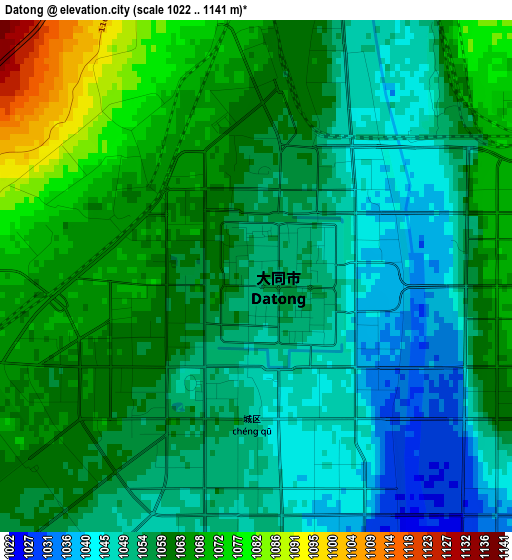
Below is the Elevation map of Datong, which displays elevation range with different colors. Scale of the first map is from 1022 to 1141 m (3353 to 3743 ft) with average elevation of 1057.9 meters (=3471 ft) [note 1]
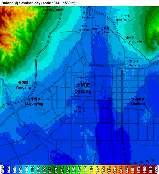
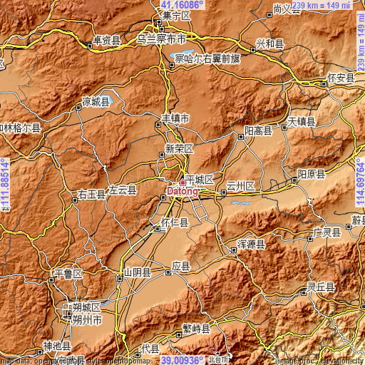
These maps also provides idea of topography and contour of this city, they are displayed at different zoom levels. More info about maps, scale and edge coordinates you can find below images.
| \ | Map #1 | Map #2 | Topo.Map |
| Scale [m] | 1022..1141 m | 1014..1530 m | × |
| Scale [ft] | 3353..3743 ft | 3327..5020 ft | × |
| Average | 1057.9 m = 3471 ft | 1088.6 m = 3572 ft | × |
| Width | 7.48 km = 4.6 mi | 14.95 km = 9.3 mi | 239.2 km = 148.6 mi |
| Height | 7.48 km = 4.6 mi | 14.95 km = 9.3 mi | 239.2 km = 148.6 mi |
| ↑Max Latitude | 40.12722° | 40.160813° | 41.16086° |
| Latitude at center | 40.09361° | 40.09361° | 40.09361° |
| ↓Min Latitude | 40.059984° | 40.026341° | 39.00936° |
| ← Min Longitude | 113.247445° | 113.203499° | 111.88514° |
| Longitude center | 113.29139° | 113.29139° | 113.29139° |
| →Max Longitude | 113.335335° | 113.379281° | 114.69764° |
Nearby cities:
Cities around Datong sort by population:
• Beichengqu elevation 1196 m
40.2 km,  343°
343°
• Xicheng 924 m
73.8 km,  88°
88°
• Xincheng 1340 m
71.6 km,  260°
260°
• Yuquan 1063 m
69.7 km,  56°
56°
• Yingxian 1006 m
60.1 km,  188°
188°
• Yong’an 1093 m
55.6 km,  142°
142°
• Yunxing 1327 m
51.6 km, 258°
• Longquan 1385 m
43.8 km,  46°
46°
• Yunzhong 1039 m
34 km,  209°
209°
• Xiping 1040 m
27.3 km,  102°
102°
• Xinrong 1196 m
22.5 km,  324°
324°
• Kouquan 1078 m
16.4 km,  229°
229°
Multilingual:
 En español:
Datong elevación 1054 m.
 En France:
Datong élévation 1054 m.


Sources and notes:
- [note 1] Map square and city borders are not equal. Map elevation data is calculated only from area inside that square.
- [src 1] Elevation data from geonames database provided with same terms of usage.
- [src 2] The elevation map of Datong is generated using elevation data from NASA's 3 arcsec (90m) resolution SRTM data.
- [src 3] Base (background) map © OpenStreetMap contributors tiles are generated by Geofabrik and OpenTopoMap.
Copyright & License:
This Datong Elevation Map is licensed under CC BY-SA. You may reuse any part from this page, if you give a proper credit by linking to this URL:
 More info on terms of use page.