Dongning elevation
Dongning (Heilongjiang), China elevation is 114 meters and Dongning elevation in feet is 374 ft above sea level [src 1]. Dongning is a seat of a third-order administrative division (feature code) with elevation that is 444 meters (1457 ft) smaller than average city elevation in China.
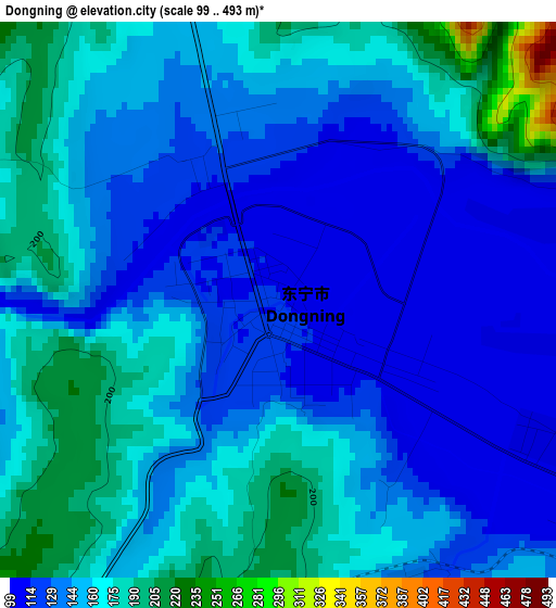
Below is the Elevation map of Dongning, which displays elevation range with different colors. Scale of the first map is from 99 to 493 m (325 to 1617 ft) with average elevation of 150.8 meters (=495 ft) [note 1]
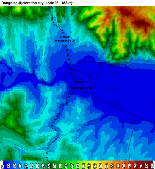
These maps also provides idea of topography and contour of this city, they are displayed at different zoom levels. More info about maps, scale and edge coordinates you can find below images.
| \ | Map #1 | Map #2 | Topo.Map |
| Scale [m] | 99..493 m | 93..856 m | × |
| Scale [ft] | 325..1617 ft | 305..2808 ft | × |
| Average | 150.8 m = 495 ft | 235.4 m = 772 ft | × |
| Width | 7.02 km = 4.4 mi | 14.04 km = 8.7 mi | 224.7 km = 139.6 mi |
| Height | 7.02 km = 4.4 mi | 14.04 km = 8.7 mi | 224.7 km = 139.6 mi |
| ↑Max Latitude | 44.09376° | 44.125313° | 45.06407° |
| Latitude at center | 44.06219° | 44.06219° | 44.06219° |
| ↓Min Latitude | 44.030603° | 43.998999° | 43.04306° |
| ← Min Longitude | 131.076805° | 131.032859° | 129.7145° |
| Longitude center | 131.12075° | 131.12075° | 131.12075° |
| →Max Longitude | 131.164695° | 131.208641° | 132.527° |
Nearby cities:
Cities around Dongning sort by population:
• Mudanjiang elevation 242 m
134.1 km,  295°
295°
• Fendou 223 m
129 km,  352°
352°
• Bamiantong 264 m
106.4 km,  333°
333°
• Jidong 225 m
128.4 km,  358°
358°
• Suifenhe 441 m
37.6 km,  3°
3°
• Xiangyang 244 m
135.8 km, 295°
• Ning’an 259 m
135.6 km,  283°
283°
• Mashan 272 m
135.5 km,  339°
339°
• Xianfeng 241 m
133.6 km, 295°
• Yangming 234 m
133.3 km, 296°
• Xin’an 233 m
132.1 km, 295°
• Lishu 237 m
119.2 km, 343°
Multilingual:
 En español:
Dongning elevación 114 m.
 En France:
Dongning élévation 114 m.
 Auf Deutsch:
Dongning höhe über dem Meeresspiegel ist 114 m.

Sources and notes:
- [note 1] Map square and city borders are not equal. Map elevation data is calculated only from area inside that square.
- [src 1] Elevation data from geonames database provided with same terms of usage.
- [src 2] The elevation map of Dongning is generated using elevation data from NASA's 3 arcsec (90m) resolution SRTM data.
- [src 3] Base (background) map © OpenStreetMap contributors tiles are generated by Geofabrik and OpenTopoMap.
Copyright & License:
This Dongning Elevation Map is licensed under CC BY-SA. You may reuse any part from this page, if you give a proper credit by linking to this URL:
 More info on terms of use page.