Hohhot elevation
Hohhot (Inner Mongolia), China elevation is 1051 meters and Hohhot elevation in feet is 3448 ft above sea level [src 1]. Hohhot is a seat of a first-order administrative division (feature code) with elevation that is 493 meters (1617 ft) bigger than average city elevation in China.
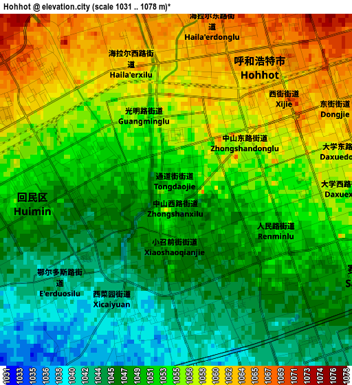
Below is the Elevation map of Hohhot, which displays elevation range with different colors. Scale of the first map is from 1031 to 1078 m (3383 to 3537 ft) with average elevation of 1052.4 meters (=3453 ft) [note 1]
These maps also provides idea of topography and contour of this city, they are displayed at different zoom levels. More info about maps, scale and edge coordinates you can find below images.
| \ | Map #1 | Map #2 | Topo.Map |
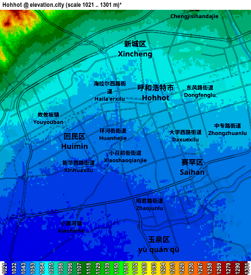
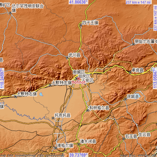
| Scale [m] | 1031..1078 m | 1021..1301 m | × |
| Scale [ft] | 3383..3537 ft | 3350..4268 ft | × |
| Average | 1052.4 m = 3453 ft | 1060.4 m = 3479 ft | × |
| Width | 7.4 km = 4.6 mi | 14.79 km = 9.2 mi | 236.7 km = 147.1 mi |
| Height | 7.4 km = 4.6 mi | 14.79 km = 9.2 mi | 236.7 km = 147.1 mi |
| ↑Max Latitude | 40.843813° | 40.877049° | 41.86636° |
| Latitude at center | 40.81056° | 40.81056° | 40.81056° |
| ↓Min Latitude | 40.777291° | 40.744004° | 39.73769° |
| ← Min Longitude | 111.608275° | 111.564329° | 110.24597° |
| Longitude center | 111.65222° | 111.65222° | 111.65222° |
| →Max Longitude | 111.696165° | 111.740111° | 113.05847° |
Nearby cities:
Cities around Hohhot sort by population:
• Jining elevation 1409 m
124.5 km,  78°
78°
• Shiguai 1337 m
115.7 km,  264°
264°
• Salaqi 1000 m
100.8 km,  252°
252°
• Xincheng 1340 m
114.4 km,  143°
143°
• Xuejiawan 1138 m
111.1 km,  199°
199°
• Chengguan 1152 m
100.5 km,  178°
178°
• Hobor 1745 m
96.5 km,  57°
57°
• Ulan Hua 1492 m
78.2 km,  2°
2°
• Daihai 1258 m
77.9 km,  114°
114°
• Zhuozishan 1447 m
77 km, 82°
• Qasq 1026 m
45.4 km, 256°
• Hoh Ereg 1582 m
36.3 km,  330°
330°
Multilingual:
 En español:
Hohhot elevación 1051 m.
 En France:
Hohhot élévation 1051 m.


Sources and notes:
- [note 1] Map square and city borders are not equal. Map elevation data is calculated only from area inside that square.
- [src 1] Elevation data from geonames database provided with same terms of usage.
- [src 2] The elevation map of Hohhot is generated using elevation data from NASA's 3 arcsec (90m) resolution SRTM data.
- [src 3] Base (background) map © OpenStreetMap contributors tiles are generated by Geofabrik and OpenTopoMap.
Copyright & License:
This Hohhot Elevation Map is licensed under CC BY-SA. You may reuse any part from this page, if you give a proper credit by linking to this URL:
 More info on terms of use page.