Huangnihe elevation
Huangnihe (Jilin), China elevation is 490 meters and Huangnihe elevation in feet is 1608 ft above sea level [src 1]. Huangnihe is a populated place (feature code) with elevation that is 68 meters (223 ft) smaller than average city elevation in China.
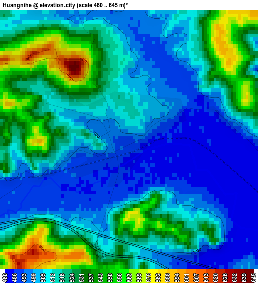
Below is the Elevation map of Huangnihe, which displays elevation range with different colors. Scale of the first map is from 480 to 645 m (1575 to 2116 ft) with average elevation of 516.3 meters (=1694 ft) [note 1]
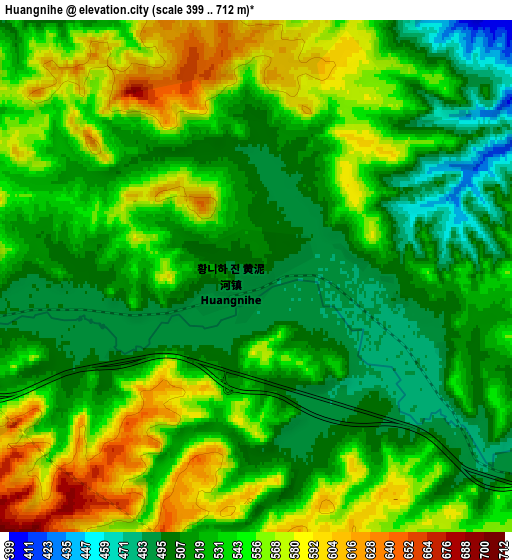
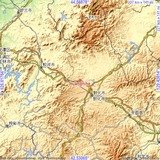
These maps also provides idea of topography and contour of this city, they are displayed at different zoom levels. More info about maps, scale and edge coordinates you can find below images.
| \ | Map #1 | Map #2 | Topo.Map |
| Scale [m] | 480..645 m | 399..712 m | × |
| Scale [ft] | 1575..2116 ft | 1309..2336 ft | × |
| Average | 516.3 m = 1694 ft | 535.1 m = 1756 ft | × |
| Width | 7.08 km = 4.4 mi | 14.16 km = 8.8 mi | 226.6 km = 140.8 mi |
| Height | 7.08 km = 4.4 mi | 14.16 km = 8.8 mi | 226.6 km = 140.8 mi |
| ↑Max Latitude | 43.590168° | 43.621988° | 44.56878° |
| Latitude at center | 43.55833° | 43.55833° | 43.55833° |
| ↓Min Latitude | 43.526476° | 43.494604° | 42.53065° |
| ← Min Longitude | 127.979945° | 127.935999° | 126.61764° |
| Longitude center | 128.02389° | 128.02389° | 128.02389° |
| →Max Longitude | 128.067835° | 128.111781° | 129.43014° |
Nearby cities:
Cities around Huangnihe sort by population:
• Jilin elevation 196 m
122.1 km,  285°
285°
• Yanji 178 m
140.3 km,  121°
121°
• Dunhua 501 m
27.2 km,  139°
139°
• Huadian 268 m
122.7 km,  237°
237°
• Minzhu 279 m
58.4 km, 288°
• Jishu 250 m
129.3 km,  310°
310°
• Helong 447 m
138.1 km,  145°
145°
• Shulan 233 m
128.4 km,  318°
318°
• Dashitou 524 m
48.3 km,  125°
125°
• Mingyue 378 m
88.3 km, 124°
• Baishishan 348 m
36.9 km,  274°
274°
• Kouqian 240 m
126.4 km, 274°
Multilingual:
 En español:
Huangnihe elevación 490 m.
 En France:
Huangnihe élévation 490 m.
 Auf Deutsch:
Huangnihe höhe über dem Meeresspiegel ist 490 m.

Sources and notes:
- [note 1] Map square and city borders are not equal. Map elevation data is calculated only from area inside that square.
- [src 1] Elevation data from geonames database provided with same terms of usage.
- [src 2] The elevation map of Huangnihe is generated using elevation data from NASA's 3 arcsec (90m) resolution SRTM data.
- [src 3] Base (background) map © OpenStreetMap contributors tiles are generated by Geofabrik and OpenTopoMap.
Copyright & License:
This Huangnihe Elevation Map is licensed under CC BY-SA. You may reuse any part from this page, if you give a proper credit by linking to this URL:
 More info on terms of use page.