Hushitai elevation
Hushitai (Liaoning), China elevation is 66 meters and Hushitai elevation in feet is 217 ft above sea level [src 1]. Hushitai is a populated place (feature code) with elevation that is 492 meters (1614 ft) smaller than average city elevation in China.
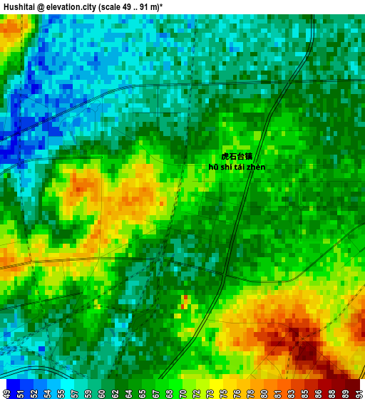
Below is the Elevation map of Hushitai, which displays elevation range with different colors. Scale of the first map is from 49 to 91 m (161 to 299 ft) with average elevation of 64.9 meters (=213 ft) [note 1]
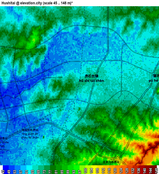
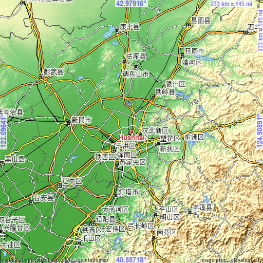
These maps also provides idea of topography and contour of this city, they are displayed at different zoom levels. More info about maps, scale and edge coordinates you can find below images.
| \ | Map #1 | Map #2 | Topo.Map |
| Scale [m] | 49..91 m | 45..148 m | × |
| Scale [ft] | 161..299 ft | 148..486 ft | × |
| Average | 64.9 m = 213 ft | 69.6 m = 228 ft | × |
| Width | 7.27 km = 4.5 mi | 14.54 km = 9 mi | 232.6 km = 144.5 mi |
| Height | 7.27 km = 4.5 mi | 14.54 km = 9 mi | 232.6 km = 144.5 mi |
| ↑Max Latitude | 41.974429° | 42.007092° | 42.97916° |
| Latitude at center | 41.94175° | 41.94175° | 41.94175° |
| ↓Min Latitude | 41.909054° | 41.876341° | 40.88718° |
| ← Min Longitude | 123.458715° | 123.414769° | 122.09641° |
| Longitude center | 123.50266° | 123.50266° | 123.50266° |
| →Max Longitude | 123.546605° | 123.590551° | 124.90891° |
Nearby cities:
Cities around Hushitai sort by population:
• Shenyang elevation 53 m
17.6 km,  199°
199°
• Fushun 83 m
37 km,  99°
99°
• Benxi 212 m
75.8 km,  163°
163°
• Liaoyang 33 m
79.4 km, 200°
• Tieling 64 m
48 km,  35°
35°
• Dongling 53 m
15.4 km, 156°
• Sujiatun 40 m
34.2 km, 203°
• Kaiyuan 91 m
79.3 km,  33°
33°
• Xinmin 34 m
56.3 km,  275°
275°
• Xiaoshi 206 m
88.2 km,  144°
144°
• Liaozhong 16 m
80.7 km,  233°
233°
• Kangping 101 m
89.6 km,  351°
351°
Multilingual:
 En español:
Hushitai elevación 66 m.
 En France:
Hushitai élévation 66 m.


Sources and notes:
- [note 1] Map square and city borders are not equal. Map elevation data is calculated only from area inside that square.
- [src 1] Elevation data from geonames database provided with same terms of usage.
- [src 2] The elevation map of Hushitai is generated using elevation data from NASA's 3 arcsec (90m) resolution SRTM data.
- [src 3] Base (background) map © OpenStreetMap contributors tiles are generated by Geofabrik and OpenTopoMap.
Copyright & License:
This Hushitai Elevation Map is licensed under CC BY-SA. You may reuse any part from this page, if you give a proper credit by linking to this URL:
 More info on terms of use page.