Jingpeng elevation
Jingpeng (Inner Mongolia), China elevation is 1100 meters and Jingpeng elevation in feet is 3609 ft above sea level [src 1]. Jingpeng is a seat of a third-order administrative division (feature code) with elevation that is 542 meters (1778 ft) bigger than average city elevation in China.
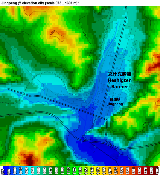
Below is the Elevation map of Jingpeng, which displays elevation range with different colors. Scale of the first map is from 975 to 1301 m (3199 to 4268 ft) with average elevation of 1078.4 meters (=3538 ft) [note 1]
These maps also provides idea of topography and contour of this city, they are displayed at different zoom levels. More info about maps, scale and edge coordinates you can find below images.
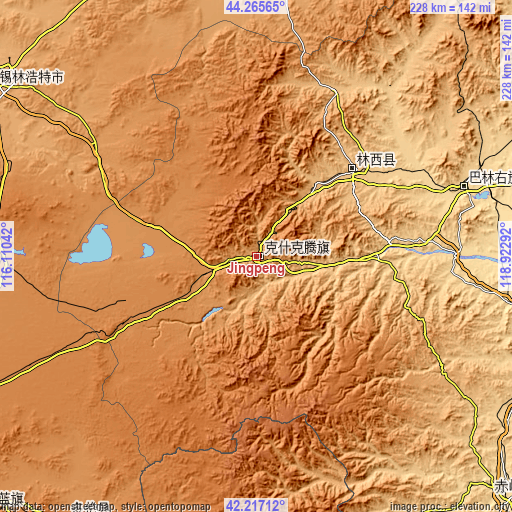
| \ | Map #1 | Topo.Map |
| Scale [m] | 975..1301 m | × |
| Scale [ft] | 3199..4268 ft | × |
| Average | 1078.4 m = 3538 ft | × |
| Width | 7.12 km = 4.4 mi | 227.8 km = 141.5 mi |
| Height | 7.12 km = 4.4 mi | 227.8 km = 141.5 mi |
| ↑Max Latitude | 43.282° | 44.26565° |
| Latitude at center | 43.25° | 43.25° |
| ↓Min Latitude | 43.217983° | 42.21712° |
| ← Min Longitude | 117.472725° | 116.11042° |
| Longitude center | 117.51667° | 117.51667° |
| →Max Longitude | 117.560615° | 118.92292° |
Nearby cities:
Cities around Jingpeng sort by population:
• Chifeng elevation 570 m
160.8 km,  132°
132°
• Xilin Hot 982 m
143.6 km,  303°
303°
• Mujiayingzi 687 m
163.1 km,  140°
140°
• Shangdu 1303 m
165.9 km,  227°
227°
• Lindong 1019 m
157 km,  58°
58°
• Bala Ga’er Gaole 996 m
149.4 km,  3°
3°
• Weichang 887 m
146.4 km,  172°
172°
• Duolun 1240 m
145 km,  215°
215°
• Xiritala 988 m
139.4 km, 303°
• Wudan 633 m
127.3 km,  105°
105°
• Daban 632 m
98.1 km,  71°
71°
• Linxi 858 m
51.2 km,  54°
54°
Multilingual:
 En español:
Jingpeng elevación 1100 m.
 En France:
Jingpeng élévation 1100 m.
 Auf Deutsch:
Jingpeng höhe über dem Meeresspiegel ist 1100 m.

Sources and notes:
- [note 1] Map square and city borders are not equal. Map elevation data is calculated only from area inside that square.
- [src 1] Elevation data from geonames database provided with same terms of usage.
- [src 2] The elevation map of Jingpeng is generated using elevation data from NASA's 3 arcsec (90m) resolution SRTM data.
- [src 3] Base (background) map © OpenStreetMap contributors tiles are generated by Geofabrik and OpenTopoMap.
Copyright & License:
This Jingpeng Elevation Map is licensed under CC BY-SA. You may reuse any part from this page, if you give a proper credit by linking to this URL:
 More info on terms of use page.