Kuandian elevation
Kuandian (Liaoning), China elevation is 281 meters and Kuandian elevation in feet is 922 ft above sea level [src 1]. Kuandian is a populated place (feature code) with elevation that is 277 meters (909 ft) smaller than average city elevation in China.
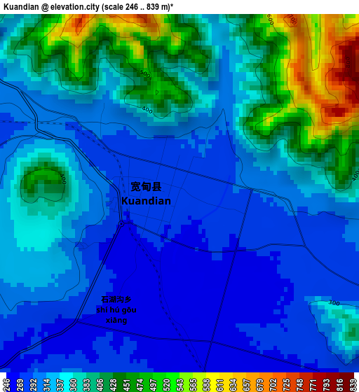
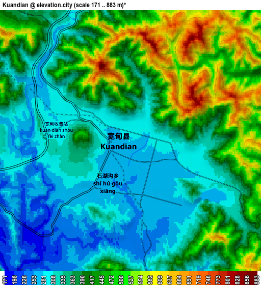
Below is the Elevation map of Kuandian, which displays elevation range with different colors. Scale of the first map is from 246 to 839 m (807 to 2753 ft) with average elevation of 349.6 meters (=1147 ft) [note 1]
These maps also provides idea of topography and contour of this city, they are displayed at different zoom levels. More info about maps, scale and edge coordinates you can find below images.
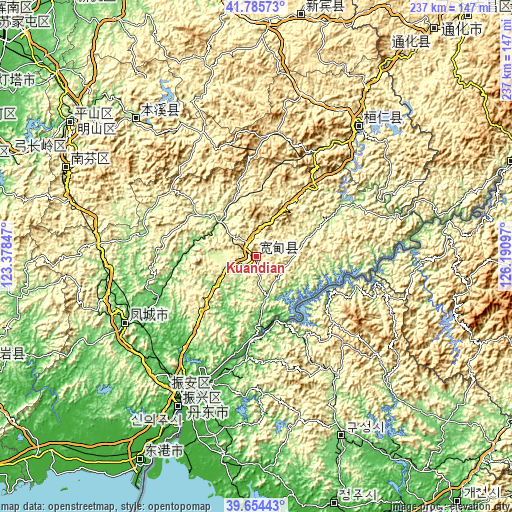
| \ | Map #1 | Map #2 | Topo.Map |
| Scale [m] | 246..839 m | 171..883 m | × |
| Scale [ft] | 807..2753 ft | 561..2897 ft | × |
| Average | 349.6 m = 1147 ft | 389.9 m = 1279 ft | × |
| Width | 7.41 km = 4.6 mi | 14.81 km = 9.2 mi | 237 km = 147.3 mi |
| Height | 7.41 km = 4.6 mi | 14.81 km = 9.2 mi | 237 km = 147.3 mi |
| ↑Max Latitude | 40.761904° | 40.795181° | 41.78573° |
| Latitude at center | 40.72861° | 40.72861° | 40.72861° |
| ↓Min Latitude | 40.6953° | 40.661972° | 39.65443° |
| ← Min Longitude | 124.740775° | 124.696829° | 123.37847° |
| Longitude center | 124.78472° | 124.78472° | 124.78472° |
| →Max Longitude | 124.828665° | 124.872611° | 126.19097° |
Nearby cities:
Cities around Kuandian sort by population:
• Benxi elevation 212 m
105.8 km,  306°
306°
• Dandong 10 m
74.4 km,  206°
206°
• Tonghua 375 m
145.8 km,  40°
40°
• Fengcheng 65 m
67.5 km,  243°
243°
• Xiuyan 82 m
136.6 km,  249°
249°
• Gongchangling 214 m
120.1 km,  291°
291°
• Xiaoshi 206 m
84.2 km,  318°
318°
• Huanren 269 m
77.1 km, 39°
• Langtoucun 5 m
85.4 km, 206°
• Kuaidamao 517 m
130.5 km, 37°
• Ji’an 182 m
124.9 km,  69°
69°
• Xinxing 4 m
111 km, 210°
Multilingual:
 En español:
Kuandian elevación 281 m.
 En France:
Kuandian élévation 281 m.
 Auf Deutsch:
Kuandian höhe über dem Meeresspiegel ist 281 m.

Sources and notes:
- [note 1] Map square and city borders are not equal. Map elevation data is calculated only from area inside that square.
- [src 1] Elevation data from geonames database provided with same terms of usage.
- [src 2] The elevation map of Kuandian is generated using elevation data from NASA's 3 arcsec (90m) resolution SRTM data.
- [src 3] Base (background) map © OpenStreetMap contributors tiles are generated by Geofabrik and OpenTopoMap.
Copyright & License:
This Kuandian Elevation Map is licensed under CC BY-SA. You may reuse any part from this page, if you give a proper credit by linking to this URL:
 More info on terms of use page.