Langxiang elevation
Langxiang (Heilongjiang), China elevation is 266 meters and Langxiang elevation in feet is 873 ft above sea level [src 1]. Langxiang is a seat of a fourth-order administrative division (feature code) with elevation that is 292 meters (958 ft) smaller than average city elevation in China.
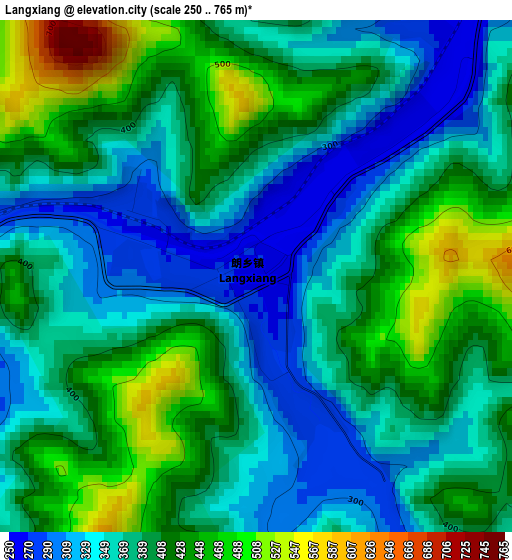
Below is the Elevation map of Langxiang, which displays elevation range with different colors. Scale of the first map is from 250 to 765 m (820 to 2510 ft) with average elevation of 389.2 meters (=1277 ft) [note 1]
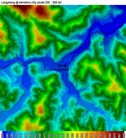
These maps also provides idea of topography and contour of this city, they are displayed at different zoom levels. More info about maps, scale and edge coordinates you can find below images.
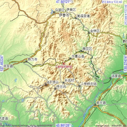
| \ | Map #1 | Map #2 | Topo.Map |
| Scale [m] | 250..765 m | 235..928 m | × |
| Scale [ft] | 820..2510 ft | 771..3045 ft | × |
| Average | 389.2 m = 1277 ft | 425.3 m = 1395 ft | × |
| Width | 6.67 km = 4.1 mi | 13.34 km = 8.3 mi | 213.5 km = 132.7 mi |
| Height | 6.67 km = 4.1 mi | 13.34 km = 8.3 mi | 213.5 km = 132.7 mi |
| ↑Max Latitude | 46.97984° | 47.009814° | 47.90121° |
| Latitude at center | 46.94985° | 46.94985° | 46.94985° |
| ↓Min Latitude | 46.919843° | 46.889819° | 45.98128° |
| ← Min Longitude | 128.824545° | 128.780599° | 127.46224° |
| Longitude center | 128.86849° | 128.86849° | 128.86849° |
| →Max Longitude | 128.912435° | 128.956381° | 130.27474° |
Nearby cities:
Cities around Langxiang sort by population:
• Yichun elevation 225 m
85.8 km,  0°
0°
• Lianhe 173 m
36.9 km,  56°
56°
• Tieli 214 m
62.6 km,  273°
273°
• Yilan 98 m
87.8 km,  143°
143°
• Shuguang 253 m
87.3 km,  350°
350°
• Xuri 231 m
86.4 km, 1°
• Wumahe 244 m
86.2 km,  356°
356°
• Tangyuan 92 m
82.3 km,  107°
107°
• Meixi 213 m
78.3 km,  14°
14°
• Xilin 192 m
67.1 km,  29°
29°
• Fendou 182 m
66.3 km,  39°
39°
• Dailing 220 m
14.1 km,  54°
54°
Multilingual:
 En español:
Langxiang elevación 266 m.
 En France:
Langxiang élévation 266 m.
 Auf Deutsch:
Langxiang höhe über dem Meeresspiegel ist 266 m.

Sources and notes:
- [note 1] Map square and city borders are not equal. Map elevation data is calculated only from area inside that square.
- [src 1] Elevation data from geonames database provided with same terms of usage.
- [src 2] The elevation map of Langxiang is generated using elevation data from NASA's 3 arcsec (90m) resolution SRTM data.
- [src 3] Base (background) map © OpenStreetMap contributors tiles are generated by Geofabrik and OpenTopoMap.
Copyright & License:
This Langxiang Elevation Map is licensed under CC BY-SA. You may reuse any part from this page, if you give a proper credit by linking to this URL:
 More info on terms of use page.