Longfeng elevation
Longfeng (Heilongjiang), China elevation is 147 meters and Longfeng elevation in feet is 482 ft above sea level [src 1]. Longfeng is a seat of a third-order administrative division (feature code) with elevation that is 411 meters (1348 ft) smaller than average city elevation in China.
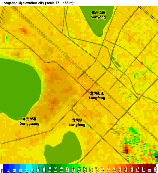
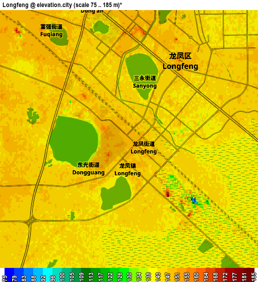
Below is the Elevation map of Longfeng, which displays elevation range with different colors. Scale of the first map is from 77 to 185 m (253 to 607 ft) with average elevation of 144 meters (=472 ft) [note 1]
These maps also provides idea of topography and contour of this city, they are displayed at different zoom levels. More info about maps, scale and edge coordinates you can find below images.
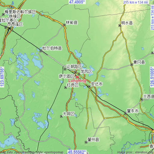
| \ | Map #1 | Map #2 | Topo.Map |
| Scale [m] | 77..185 m | 75..185 m | × |
| Scale [ft] | 253..607 ft | 246..607 ft | × |
| Average | 144 m = 472 ft | 144 m = 472 ft | × |
| Width | 6.72 km = 4.2 mi | 13.45 km = 8.4 mi | 215.1 km = 133.7 mi |
| Height | 6.72 km = 4.2 mi | 13.45 km = 8.4 mi | 215.1 km = 133.7 mi |
| ↑Max Latitude | 46.561904° | 46.592111° | 47.4905° |
| Latitude at center | 46.53168° | 46.53168° | 46.53168° |
| ↓Min Latitude | 46.501439° | 46.471182° | 45.55562° |
| ← Min Longitude | 125.059855° | 125.015909° | 123.69755° |
| Longitude center | 125.1038° | 125.1038° | 125.1038° |
| →Max Longitude | 125.147745° | 125.191691° | 126.51005° |
Nearby cities:
Cities around Longfeng sort by population:
• Fendou elevation 147 m
22.1 km,  303°
303°
• Daqing 146 m
9.8 km,  305°
305°
• Anda 148 m
21.6 km,  131°
131°
• Zhaodong 139 m
85 km, 127°
• Honggang 143 m
22.3 km,  229°
229°
• Lanxi 164 m
95.4 km,  108°
108°
• Qinggang 215 m
78.4 km,  77°
77°
• Mingshui 249 m
94.3 km,  39°
39°
• Taikang 146 m
62.4 km, 305°
• Lindian 155 m
74.6 km,  346°
346°
• Datong 135 m
59.8 km,  202°
202°
• Dong’an 146 m
7.2 km,  344°
344°
Multilingual:
 En español:
Longfeng elevación 147 m.
 En France:
Longfeng élévation 147 m.
 Auf Deutsch:
Longfeng höhe über dem Meeresspiegel ist 147 m.

Sources and notes:
- [note 1] Map square and city borders are not equal. Map elevation data is calculated only from area inside that square.
- [src 1] Elevation data from geonames database provided with same terms of usage.
- [src 2] The elevation map of Longfeng is generated using elevation data from NASA's 3 arcsec (90m) resolution SRTM data.
- [src 3] Base (background) map © OpenStreetMap contributors tiles are generated by Geofabrik and OpenTopoMap.
Copyright & License:
This Longfeng Elevation Map is licensed under CC BY-SA. You may reuse any part from this page, if you give a proper credit by linking to this URL:
 More info on terms of use page.