Zhalantun elevation
Zhalantun (Inner Mongolia), China elevation is 320 meters and Zhalantun elevation in feet is 1050 ft above sea level [src 1]. Zhalantun is a seat of a third-order administrative division (feature code) with elevation that is 238 meters (781 ft) smaller than average city elevation in China.
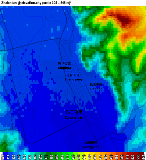
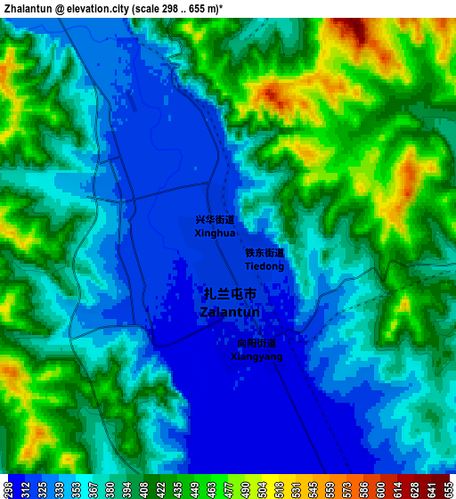
Below is the Elevation map of Zhalantun, which displays elevation range with different colors. Scale of the first map is from 305 to 545 m (1001 to 1788 ft) with average elevation of 341.1 meters (=1119 ft) [note 1]
These maps also provides idea of topography and contour of this city, they are displayed at different zoom levels. More info about maps, scale and edge coordinates you can find below images.
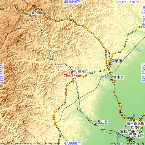
| \ | Map #1 | Map #2 | Topo.Map |
| Scale [m] | 305..545 m | 298..655 m | × |
| Scale [ft] | 1001..1788 ft | 978..2149 ft | × |
| Average | 341.1 m = 1119 ft | 384.3 m = 1261 ft | × |
| Width | 6.54 km = 4.1 mi | 13.08 km = 8.1 mi | 209.2 km = 130 mi |
| Height | 6.54 km = 4.1 mi | 13.08 km = 8.1 mi | 209.2 km = 130 mi |
| ↑Max Latitude | 48.038841° | 48.068216° | 48.94167° |
| Latitude at center | 48.00945° | 48.00945° | 48.00945° |
| ↓Min Latitude | 47.980042° | 47.950617° | 47.06007° |
| ← Min Longitude | 122.692565° | 122.648619° | 121.33026° |
| Longitude center | 122.73651° | 122.73651° | 122.73651° |
| →Max Longitude | 122.780455° | 122.824401° | 124.14276° |
Nearby cities:
Cities around Zhalantun sort by population:
• Qiqihar elevation 151 m
118 km,  129°
129°
• Hulan Ergi 152 m
112 km,  143°
143°
• Longjiang 184 m
82.4 km,  156°
156°
• Nianzishan 234 m
55.9 km,  168°
168°
• Gannan 188 m
58 km,  100°
100°
• Longhua 151 m
119.3 km, 128°
• Nanhang 151 m
119.2 km, 130°
• Bukui 156 m
116.5 km, 128°
• Hong’an 151 m
111.5 km, 143°
• Meilisi 151 m
108.5 km, 135°
• Naji 218 m
55.1 km,  76°
76°
• Xinghua 319 m
2.9 km,  281°
281°
Multilingual:
 En español:
Zhalantun elevación 320 m.
 En France:
Zhalantun élévation 320 m.
 Auf Deutsch:
Zhalantun höhe über dem Meeresspiegel ist 320 m.

Sources and notes:
- [note 1] Map square and city borders are not equal. Map elevation data is calculated only from area inside that square.
- [src 1] Elevation data from geonames database provided with same terms of usage.
- [src 2] The elevation map of Zhalantun is generated using elevation data from NASA's 3 arcsec (90m) resolution SRTM data.
- [src 3] Base (background) map © OpenStreetMap contributors tiles are generated by Geofabrik and OpenTopoMap.
Copyright & License:
This Zhalantun Elevation Map is licensed under CC BY-SA. You may reuse any part from this page, if you give a proper credit by linking to this URL:
 More info on terms of use page.