Wubao elevation
Wubao (Fujian), China elevation is 17 meters and Wubao elevation in feet is 56 ft above sea level [src 1]. Wubao is a populated place (feature code) with elevation that is 541 meters (1775 ft) smaller than average city elevation in China.
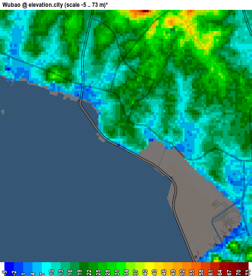
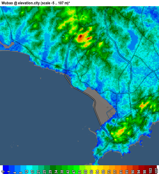
Below is the Elevation map of Wubao, which displays elevation range with different colors. Scale of the first map is from -5 to 73 m (-16 to 240 ft) with average elevation of 17 meters (=56 ft) [note 1]
These maps also provides idea of topography and contour of this city, they are displayed at different zoom levels. More info about maps, scale and edge coordinates you can find below images.
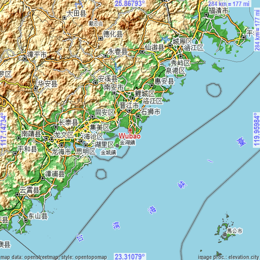
| \ | Map #1 | Map #2 | Topo.Map |
| Scale [m] | -5..73 m | -5..107 m | × |
| Scale [ft] | -16..240 ft | -16..351 ft | × |
| Average | 17 m = 56 ft | 21.7 m = 71 ft | × |
| Width | 8.89 km = 5.5 mi | 17.77 km = 11 mi | 284.3 km = 176.7 mi |
| Height | 8.89 km = 5.5 mi | 17.77 km = 11 mi | 284.3 km = 176.7 mi |
| ↑Max Latitude | 24.635842° | 24.67578° | 25.86793° |
| Latitude at center | 24.59589° | 24.59589° | 24.59589° |
| ↓Min Latitude | 24.555926° | 24.515949° | 23.31079° |
| ← Min Longitude | 118.509645° | 118.465699° | 117.14734° |
| Longitude center | 118.55359° | 118.55359° | 118.55359° |
| →Max Longitude | 118.597535° | 118.641481° | 119.95984° |
Nearby cities:
Cities around Wubao sort by population:
• Yongning elevation 21 m
16.7 km,  55°
55°
• Jinjing 14 m
5 km,  117°
117°
• Kerencun 1 m
10.9 km,  98°
98°
• Tatou 25 m
3.6 km,  311°
311°
• Yinglin 27 m
4.9 km,  34°
34°
• Shijing 16 m
13.3 km,  281°
281°
• Yakou 9 m
12 km,  44°
44°
• Maping 46 m
10.2 km,  359°
359°
• Dadeng 16 m
23.6 km,  255°
255°
• Lianhecun 1 m
21.7 km,  268°
268°
• Neikeng 52 m
23.1 km,  335°
335°
• Shishi 19 m
17.8 km, 25°
Multilingual:
 En español:
Wubao elevación 17 m.
 En France:
Wubao élévation 17 m.


Sources and notes:
- [note 1] Map square and city borders are not equal. Map elevation data is calculated only from area inside that square.
- [src 1] Elevation data from geonames database provided with same terms of usage.
- [src 2] The elevation map of Wubao is generated using elevation data from NASA's 3 arcsec (90m) resolution SRTM data.
- [src 3] Base (background) map © OpenStreetMap contributors tiles are generated by Geofabrik and OpenTopoMap.
Copyright & License:
This Wubao Elevation Map is licensed under CC BY-SA. You may reuse any part from this page, if you give a proper credit by linking to this URL:
 More info on terms of use page.