Dengjiapu elevation
Dengjiapu (Hunan), China elevation is 311 meters and Dengjiapu elevation in feet is 1020 ft above sea level [src 1]. Dengjiapu is a populated place (feature code) with elevation that is 247 meters (810 ft) smaller than average city elevation in China.
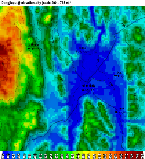
Below is the Elevation map of Dengjiapu, which displays elevation range with different colors. Scale of the first map is from 290 to 765 m (951 to 2510 ft) with average elevation of 415.2 meters (=1362 ft) [note 1]
These maps also provides idea of topography and contour of this city, they are displayed at different zoom levels. More info about maps, scale and edge coordinates you can find below images.
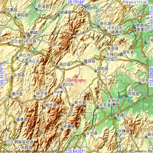
| \ | Map #1 | Topo.Map |
| Scale [m] | 290..765 m | × |
| Scale [ft] | 951..2510 ft | × |
| Average | 415.2 m = 1362 ft | × |
| Width | 8.71 km = 5.4 mi | 278.9 km = 173.3 mi |
| Height | 8.71 km = 5.4 mi | 278.9 km = 173.3 mi |
| ↑Max Latitude | 26.943622° | 28.15144° |
| Latitude at center | 26.90444° | 26.90444° |
| ↓Min Latitude | 26.865244° | 25.64351° |
| ← Min Longitude | 110.876055° | 109.51375° |
| Longitude center | 110.92° | 110.92° |
| →Max Longitude | 110.963945° | 112.32625° |
Nearby cities:
Cities around Dengjiapu sort by population:
• Shijiang elevation 277 m
23.4 km,  327°
327°
• Hexiangqiao 278 m
35.4 km,  6°
6°
• Huangqiao 265 m
15.3 km, 328°
• Zhushi 289 m
31.6 km,  310°
310°
• Gaoqiao 417 m
30.2 km,  183°
183°
• Wantouqiao 331 m
30.6 km,  256°
256°
• Hengbanqiao 294 m
30.2 km,  349°
349°
• Huayuan 343 m
38.1 km,  271°
271°
• Ma’an 295 m
21.3 km,  292°
292°
• Qingjiangqiao 323 m
34 km,  169°
169°
• Tangdukou 323 m
32.6 km,  77°
77°
• Taohong 276 m
23.1 km,  18°
18°
Multilingual:
 En español:
Dengjiapu elevación 311 m.
 En France:
Dengjiapu élévation 311 m.
 Auf Deutsch:
Dengjiapu höhe über dem Meeresspiegel ist 311 m.

Sources and notes:
- [note 1] Map square and city borders are not equal. Map elevation data is calculated only from area inside that square.
- [src 1] Elevation data from geonames database provided with same terms of usage.
- [src 2] The elevation map of Dengjiapu is generated using elevation data from NASA's 3 arcsec (90m) resolution SRTM data.
- [src 3] Base (background) map © OpenStreetMap contributors tiles are generated by Geofabrik and OpenTopoMap.
Copyright & License:
This Dengjiapu Elevation Map is licensed under CC BY-SA. You may reuse any part from this page, if you give a proper credit by linking to this URL:
 More info on terms of use page.