Dongping elevation
Dongping (Hunan), China elevation is 135 meters and Dongping elevation in feet is 443 ft above sea level [src 1]. Dongping is a seat of a third-order administrative division (feature code) with elevation that is 423 meters (1388 ft) smaller than average city elevation in China.
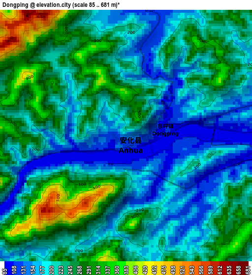
Below is the Elevation map of Dongping, which displays elevation range with different colors. Scale of the first map is from 85 to 681 m (279 to 2234 ft) with average elevation of 230.1 meters (=755 ft) [note 1]
These maps also provides idea of topography and contour of this city, they are displayed at different zoom levels. More info about maps, scale and edge coordinates you can find below images.
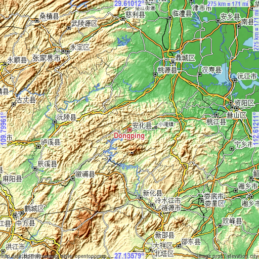
| \ | Map #1 | Topo.Map |
| Scale [m] | 85..681 m | × |
| Scale [ft] | 279..2234 ft | × |
| Average | 230.1 m = 755 ft | × |
| Width | 8.6 km = 5.3 mi | 275.1 km = 170.9 mi |
| Height | 8.6 km = 5.3 mi | 275.1 km = 170.9 mi |
| ↑Max Latitude | 28.418827° | 29.61012° |
| Latitude at center | 28.38017° | 28.38017° |
| ↓Min Latitude | 28.341499° | 27.13579° |
| ← Min Longitude | 111.161915° | 109.79961° |
| Longitude center | 111.20586° | 111.20586° |
| →Max Longitude | 111.249805° | 112.61211° |
Nearby cities:
Cities around Dongping sort by population:
• Changde elevation 35 m
87.2 km,  31°
31°
• Lengshuijiang 194 m
80 km,  164°
164°
• Shangmei 179 m
71.4 km,  172°
172°
• Lianyuan 151 m
89.1 km,  149°
149°
• Shuiche 447 m
79.7 km,  194°
194°
• Qiaojiang 169 m
71.6 km,  226°
226°
• Xixi 482 m
80.2 km,  197°
197°
• Gangdong 413 m
63.1 km,  215°
215°
• Dingcheng 39 m
84.8 km, 33°
• Lufeng 162 m
80.2 km, 229°
• Yuanling 120 m
79 km,  275°
275°
• Zhangjiang 46 m
64.8 km,  24°
24°
Multilingual:
 En español:
Dongping elevación 135 m.
 En France:
Dongping élévation 135 m.
 Auf Deutsch:
Dongping höhe über dem Meeresspiegel ist 135 m.

Sources and notes:
- [note 1] Map square and city borders are not equal. Map elevation data is calculated only from area inside that square.
- [src 1] Elevation data from geonames database provided with same terms of usage.
- [src 2] The elevation map of Dongping is generated using elevation data from NASA's 3 arcsec (90m) resolution SRTM data.
- [src 3] Base (background) map © OpenStreetMap contributors tiles are generated by Geofabrik and OpenTopoMap.
Copyright & License:
This Dongping Elevation Map is licensed under CC BY-SA. You may reuse any part from this page, if you give a proper credit by linking to this URL:
 More info on terms of use page.