Ganzhou elevation
Ganzhou (Jiangxi), China elevation is 117 meters and Ganzhou elevation in feet is 384 ft above sea level [src 1]. Ganzhou is a seat of a second-order administrative division (feature code) with elevation that is 441 meters (1447 ft) smaller than average city elevation in China.
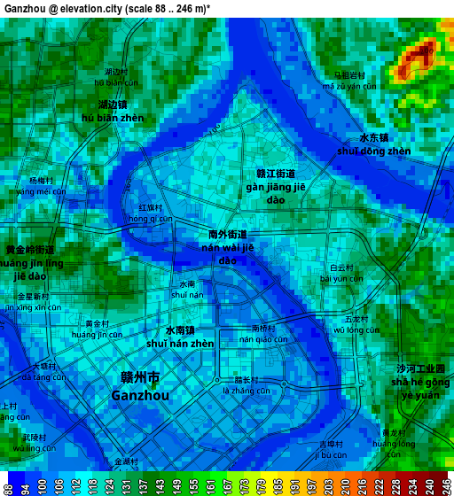
Below is the Elevation map of Ganzhou, which displays elevation range with different colors. Scale of the first map is from 88 to 246 m (289 to 807 ft) with average elevation of 118 meters (=387 ft) [note 1]
These maps also provides idea of topography and contour of this city, they are displayed at different zoom levels. More info about maps, scale and edge coordinates you can find below images.
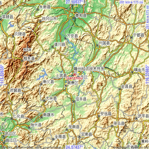
| \ | Map #1 | Topo.Map |
| Scale [m] | 88..246 m | × |
| Scale [ft] | 289..807 ft | × |
| Average | 118 m = 387 ft | × |
| Width | 8.79 km = 5.5 mi | 281.4 km = 174.9 mi |
| Height | 8.79 km = 5.5 mi | 281.4 km = 174.9 mi |
| ↑Max Latitude | 25.886183° | 27.10537° |
| Latitude at center | 25.84664° | 25.84664° |
| ↓Min Latitude | 25.807084° | 24.57437° |
| ← Min Longitude | 114.888655° | 113.52635° |
| Longitude center | 114.9326° | 114.9326° |
| →Max Longitude | 114.976545° | 116.33885° |
Nearby cities:
Cities around Ganzhou sort by population:
• Guidong Chengguanzhen elevation 826 m
102.5 km,  284°
284°
• Xinshan 288 m
91.1 km,  149°
149°
• Huichang 173 m
89 km,  107°
107°
• Nan’an 182 m
75.8 km,  229°
229°
• Furong 139 m
69.1 km,  346°
346°
• Quanjiang 99 m
66.4 km,  320°
320°
• Hengshui 418 m
63.8 km,  255°
255°
• Gongjiang 131 m
49.3 km,  75°
75°
• Jiading 151 m
46.4 km,  180°
180°
• Dongshan 140 m
39.5 km, 261°
• Rongjiang 128 m
27.4 km,  221°
221°
• Meilin 123 m
8.4 km,  69°
69°
Multilingual:
 En español:
Ganzhou elevación 117 m.
 En France:
Ganzhou élévation 117 m.


Sources and notes:
- [note 1] Map square and city borders are not equal. Map elevation data is calculated only from area inside that square.
- [src 1] Elevation data from geonames database provided with same terms of usage.
- [src 2] The elevation map of Ganzhou is generated using elevation data from NASA's 3 arcsec (90m) resolution SRTM data.
- [src 3] Base (background) map © OpenStreetMap contributors tiles are generated by Geofabrik and OpenTopoMap.
Copyright & License:
This Ganzhou Elevation Map is licensed under CC BY-SA. You may reuse any part from this page, if you give a proper credit by linking to this URL:
 More info on terms of use page.