Huanggang elevation
Huanggang (Guangdong), China elevation is 13 meters and Huanggang elevation in feet is 43 ft above sea level [src 1]. Huanggang is a seat of a third-order administrative division (feature code) with elevation that is 545 meters (1788 ft) smaller than average city elevation in China.
Below is the Elevation map of Huanggang, which displays elevation range with different colors. Scale of the first map is from -4 to 200 m (-13 to 656 ft) with average elevation of 24.8 meters (=81 ft) [note 1]
These maps also provides idea of topography and contour of this city, they are displayed at different zoom levels. More info about maps, scale and edge coordinates you can find below images.
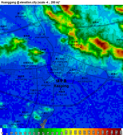
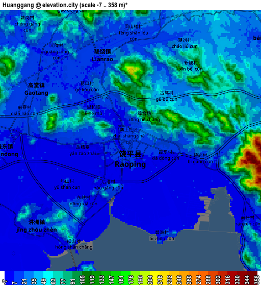
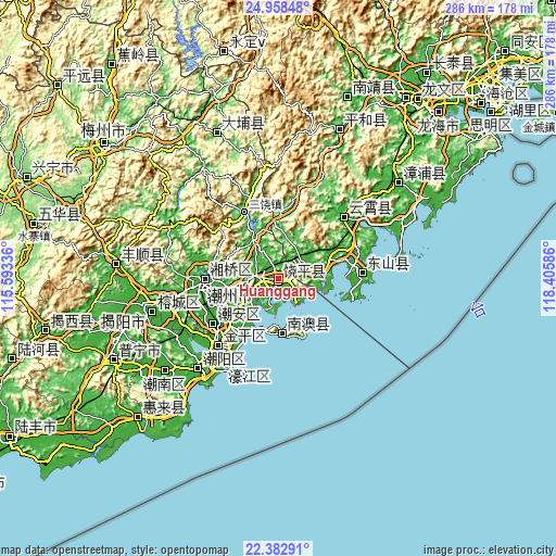
| \ | Map #1 | Map #2 | Topo.Map |
| Scale [m] | -4..200 m | -7..358 m | × |
| Scale [ft] | -13..656 ft | -23..1175 ft | × |
| Average | 24.8 m = 81 ft | 31.4 m = 103 ft | × |
| Width | 8.95 km = 5.6 mi | 17.9 km = 11.1 mi | 286.4 km = 178 mi |
| Height | 8.95 km = 5.6 mi | 17.9 km = 11.1 mi | 286.4 km = 178 mi |
| ↑Max Latitude | 23.71728° | 23.757507° | 24.95848° |
| Latitude at center | 23.67704° | 23.67704° | 23.67704° |
| ↓Min Latitude | 23.636788° | 23.596523° | 22.38291° |
| ← Min Longitude | 116.955665° | 116.911719° | 115.59336° |
| Longitude center | 116.99961° | 116.99961° | 116.99961° |
| →Max Longitude | 117.043555° | 117.087501° | 118.40586° |
Nearby cities:
Cities around Huanggang sort by population:
• Shantou elevation 17 m
45 km,  220°
220°
• Jieyang 7 m
66.3 km,  256°
256°
• Chaozhou 23 m
38.5 km,  266°
266°
• Anbu 15 m
41.2 km,  232°
232°
• Chenghua 13 m
33.5 km, 224°
• Haimen 17 m
66.7 km, 216°
• Xiaoxi 136 m
80.7 km,  21°
21°
• Sui’an 13 m
76.9 km,  53°
53°
• Chengnan 20 m
60.4 km, 221°
• Yunling 11 m
46 km, 48°
• Xipu 16 m
43.4 km,  86°
86°
• Nanzhao 20 m
18.1 km,  74°
74°
Multilingual:
 En español:
Huanggang elevación 13 m.
 En France:
Huanggang élévation 13 m.
 Auf Deutsch:
Huanggang höhe über dem Meeresspiegel ist 13 m.

Sources and notes:
- [note 1] Map square and city borders are not equal. Map elevation data is calculated only from area inside that square.
- [src 1] Elevation data from geonames database provided with same terms of usage.
- [src 2] The elevation map of Huanggang is generated using elevation data from NASA's 3 arcsec (90m) resolution SRTM data.
- [src 3] Base (background) map © OpenStreetMap contributors tiles are generated by Geofabrik and OpenTopoMap.
Copyright & License:
This Huanggang Elevation Map is licensed under CC BY-SA. You may reuse any part from this page, if you give a proper credit by linking to this URL:
 More info on terms of use page.