Jingdezhen elevation
Jingdezhen (Jiangxi), China elevation is 48 meters and Jingdezhen elevation in feet is 157 ft above sea level [src 1]. Jingdezhen is a seat of a second-order administrative division (feature code) with elevation that is 510 meters (1673 ft) smaller than average city elevation in China.
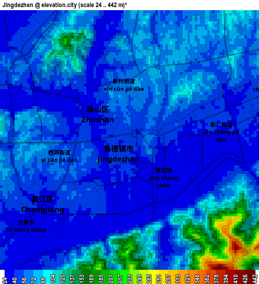
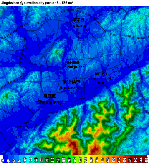
Below is the Elevation map of Jingdezhen, which displays elevation range with different colors. Scale of the first map is from 24 to 442 m (79 to 1450 ft) with average elevation of 65.3 meters (=214 ft) [note 1]
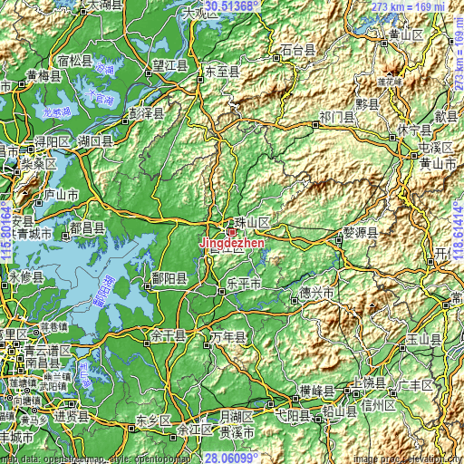
These maps also provides idea of topography and contour of this city, they are displayed at different zoom levels. More info about maps, scale and edge coordinates you can find below images.
| \ | Map #1 | Map #2 | Topo.Map |
| Scale [m] | 24..442 m | 18..586 m | × |
| Scale [ft] | 79..1450 ft | 59..1923 ft | × |
| Average | 65.3 m = 214 ft | 93.8 m = 308 ft | × |
| Width | 8.52 km = 5.3 mi | 17.05 km = 10.6 mi | 272.7 km = 169.4 mi |
| Height | 8.52 km = 5.3 mi | 17.05 km = 10.6 mi | 272.7 km = 169.4 mi |
| ↑Max Latitude | 29.333018° | 29.371322° | 30.51368° |
| Latitude at center | 29.2947° | 29.2947° | 29.2947° |
| ↓Min Latitude | 29.256367° | 29.218021° | 28.06099° |
| ← Min Longitude | 117.163945° | 117.119999° | 115.80164° |
| Longitude center | 117.20789° | 117.20789° | 117.20789° |
| →Max Longitude | 117.251835° | 117.295781° | 118.61414° |
Nearby cities:
Cities around Jingdezhen sort by population:
• Poyang elevation 23 m
62.3 km,  237°
237°
• Wucheng 149 m
99.6 km,  70°
70°
• Qili 108 m
103.9 km,  14°
14°
• Biyang 203 m
100.3 km,  45°
45°
• Duchang 27 m
99.1 km,  268°
268°
• Longcheng 117 m
92 km,  316°
316°
• Yaodu 18 m
91.4 km,  348°
348°
• Qishan 164 m
78.6 km,  38°
38°
• Chenying 53 m
68.3 km,  191°
191°
• Ziyang 93 m
62.9 km,  94°
94°
• Leping 23 m
37.5 km, 193°
• Fuliang 48 m
9.8 km,  22°
22°
Multilingual:
 En español:
Jingdezhen elevación 48 m.
 En France:
Jingdezhen élévation 48 m.
 Auf Deutsch:
Jingdezhen höhe über dem Meeresspiegel ist 48 m.

Sources and notes:
- [note 1] Map square and city borders are not equal. Map elevation data is calculated only from area inside that square.
- [src 1] Elevation data from geonames database provided with same terms of usage.
- [src 2] The elevation map of Jingdezhen is generated using elevation data from NASA's 3 arcsec (90m) resolution SRTM data.
- [src 3] Base (background) map © OpenStreetMap contributors tiles are generated by Geofabrik and OpenTopoMap.
Copyright & License:
This Jingdezhen Elevation Map is licensed under CC BY-SA. You may reuse any part from this page, if you give a proper credit by linking to this URL:
 More info on terms of use page.