Jinshi elevation
Jinshi (Hunan), China elevation is 65 meters and Jinshi elevation in feet is 213 ft above sea level [src 1]. Jinshi is a seat of a third-order administrative division (feature code) with elevation that is 493 meters (1617 ft) smaller than average city elevation in China.
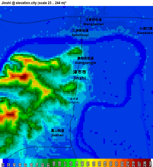
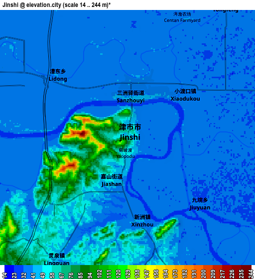
Below is the Elevation map of Jinshi, which displays elevation range with different colors. Scale of the first map is from 23 to 244 m (75 to 801 ft) with average elevation of 52.9 meters (=174 ft) [note 1]
These maps also provides idea of topography and contour of this city, they are displayed at different zoom levels. More info about maps, scale and edge coordinates you can find below images.
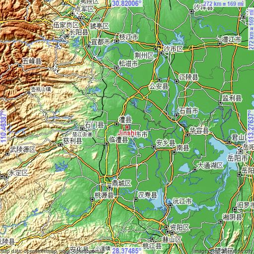
| \ | Map #1 | Map #2 | Topo.Map |
| Scale [m] | 23..244 m | 14..244 m | × |
| Scale [ft] | 75..801 ft | 46..801 ft | × |
| Average | 52.9 m = 174 ft | 43.5 m = 143 ft | × |
| Width | 8.5 km = 5.3 mi | 16.99 km = 10.6 mi | 271.9 km = 169 mi |
| Height | 8.5 km = 5.3 mi | 16.99 km = 10.6 mi | 271.9 km = 169 mi |
| ↑Max Latitude | 29.643071° | 29.681258° | 30.82006° |
| Latitude at center | 29.60487° | 29.60487° | 29.60487° |
| ↓Min Latitude | 29.566654° | 29.528424° | 28.37485° |
| ← Min Longitude | 111.826175° | 111.782229° | 110.46387° |
| Longitude center | 111.87012° | 111.87012° | 111.87012° |
| →Max Longitude | 111.914065° | 111.958011° | 113.27637° |
Nearby cities:
Cities around Jinshi sort by population:
• Changde elevation 35 m
64.8 km,  196°
196°
• Xiulin 36 m
52.7 km,  76°
76°
• Anxiang 33 m
35.4 km,  130°
130°
• Nanzhou 33 m
58.3 km,  117°
117°
• Haoxue 30 m
75.8 km,  49°
49°
• Cili 101 m
75.3 km,  254°
254°
• Dingcheng 39 m
67.7 km, 195°
• Huarong Chengguanzhen 27 m
66.3 km,  98°
98°
• Douhudi 40 m
61.1 km,  33°
33°
• Chujiang 75 m
49.1 km,  266°
266°
• Linli 50 m
27.4 km,  231°
231°
• Liyang 40 m
12.6 km,  294°
294°
Multilingual:
 En español:
Jinshi elevación 65 m.
 En France:
Jinshi élévation 65 m.


Sources and notes:
- [note 1] Map square and city borders are not equal. Map elevation data is calculated only from area inside that square.
- [src 1] Elevation data from geonames database provided with same terms of usage.
- [src 2] The elevation map of Jinshi is generated using elevation data from NASA's 3 arcsec (90m) resolution SRTM data.
- [src 3] Base (background) map © OpenStreetMap contributors tiles are generated by Geofabrik and OpenTopoMap.
Copyright & License:
This Jinshi Elevation Map is licensed under CC BY-SA. You may reuse any part from this page, if you give a proper credit by linking to this URL:
 More info on terms of use page.