Lanxi elevation
Lanxi (Zhejiang), China elevation is 38 meters and Lanxi elevation in feet is 125 ft above sea level [src 1]. Lanxi is a populated place (feature code) with elevation that is 520 meters (1706 ft) smaller than average city elevation in China.
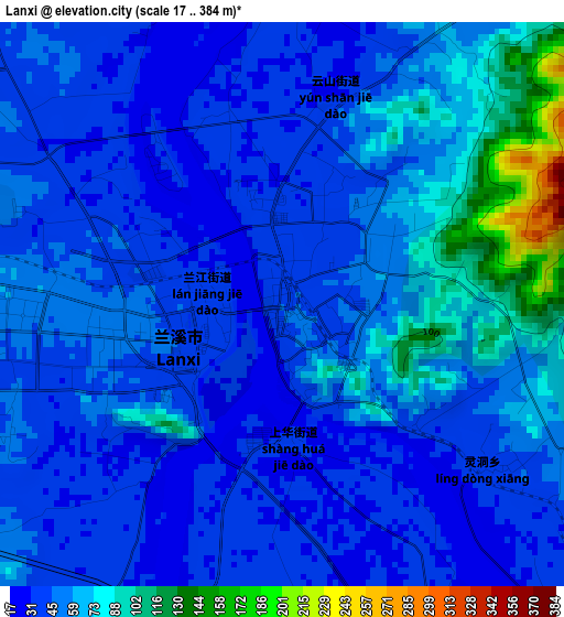
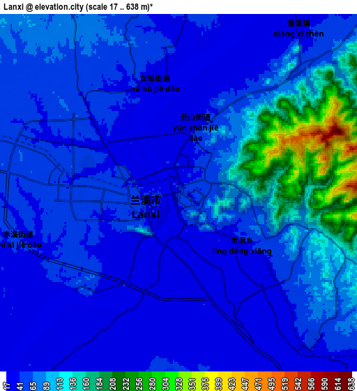
Below is the Elevation map of Lanxi, which displays elevation range with different colors. Scale of the first map is from 17 to 384 m (56 to 1260 ft) with average elevation of 53.1 meters (=174 ft) [note 1]
These maps also provides idea of topography and contour of this city, they are displayed at different zoom levels. More info about maps, scale and edge coordinates you can find below images.
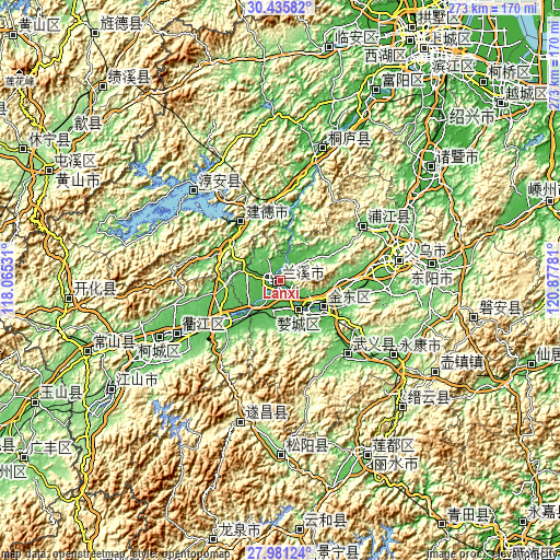
| \ | Map #1 | Map #2 | Topo.Map |
| Scale [m] | 17..384 m | 17..638 m | × |
| Scale [ft] | 56..1260 ft | 56..2093 ft | × |
| Average | 53.1 m = 174 ft | 72.6 m = 238 ft | × |
| Width | 8.53 km = 5.3 mi | 17.06 km = 10.6 mi | 272.9 km = 169.6 mi |
| Height | 8.53 km = 5.3 mi | 17.06 km = 10.6 mi | 272.9 km = 169.6 mi |
| ↑Max Latitude | 29.254228° | 29.292561° | 30.43582° |
| Latitude at center | 29.21588° | 29.21588° | 29.21588° |
| ↓Min Latitude | 29.177518° | 29.139142° | 27.98124° |
| ← Min Longitude | 119.427615° | 119.383669° | 118.06531° |
| Longitude center | 119.47156° | 119.47156° | 119.47156° |
| →Max Longitude | 119.515505° | 119.559451° | 120.87781° |
Nearby cities:
Cities around Lanxi sort by population:
• Puyang elevation 76 m
48.5 km,  56°
56°
• Guli 121 m
66 km,  124°
124°
• Jinhua 55 m
20.7 km,  125°
125°
• Dongyang 97 m
73.4 km,  85°
85°
• Yiwu 84 m
59.7 km,  79°
79°
• Quzhou 77 m
65.2 km,  244°
244°
• Wuyun 181 m
85.2 km,  137°
137°
• Dongcheng 87 m
65.9 km, 122°
• Xin’anjiang 49 m
34.7 km,  326°
326°
• Duohu 46 m
24.8 km, 123°
• Chengzhong 52 m
21.1 km, 125°
• Lanjiang 42 m
1 km,  265°
265°
Multilingual:
 En español:
Lanxi elevación 38 m.
 En France:
Lanxi élévation 38 m.


Sources and notes:
- [note 1] Map square and city borders are not equal. Map elevation data is calculated only from area inside that square.
- [src 1] Elevation data from geonames database provided with same terms of usage.
- [src 2] The elevation map of Lanxi is generated using elevation data from NASA's 3 arcsec (90m) resolution SRTM data.
- [src 3] Base (background) map © OpenStreetMap contributors tiles are generated by Geofabrik and OpenTopoMap.
Copyright & License:
This Lanxi Elevation Map is licensed under CC BY-SA. You may reuse any part from this page, if you give a proper credit by linking to this URL:
 More info on terms of use page.