Liangxiang elevation
Liangxiang (Beijing), China elevation is 47 meters and Liangxiang elevation in feet is 154 ft above sea level [src 1]. Liangxiang is a populated place (feature code) with elevation that is 511 meters (1677 ft) smaller than average city elevation in China.
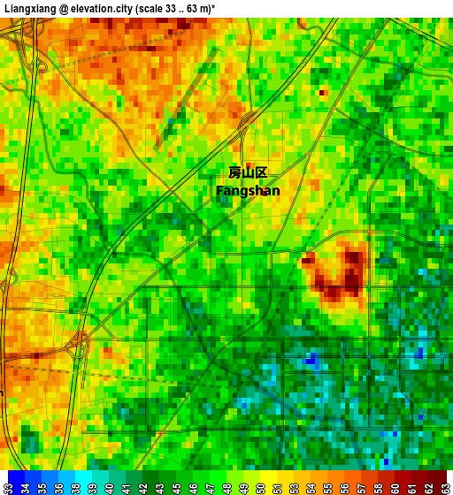
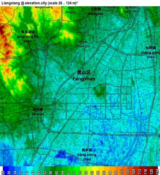
Below is the Elevation map of Liangxiang, which displays elevation range with different colors. Scale of the first map is from 33 to 63 m (108 to 207 ft) with average elevation of 47.9 meters (=157 ft) [note 1]
These maps also provides idea of topography and contour of this city, they are displayed at different zoom levels. More info about maps, scale and edge coordinates you can find below images.
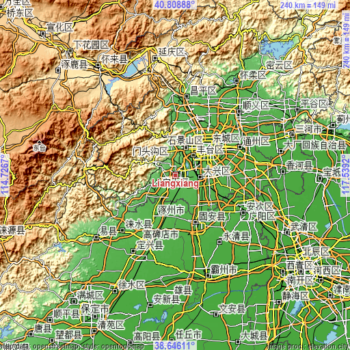
| \ | Map #1 | Map #2 | Topo.Map |
| Scale [m] | 33..63 m | 26..124 m | × |
| Scale [ft] | 108..207 ft | 85..407 ft | × |
| Average | 47.9 m = 157 ft | 52.3 m = 172 ft | × |
| Width | 7.51 km = 4.7 mi | 15.03 km = 9.3 mi | 240.5 km = 149.4 mi |
| Height | 7.52 km = 4.7 mi | 15.03 km = 9.3 mi | 240.5 km = 149.4 mi |
| ↑Max Latitude | 39.769766° | 39.803535° | 40.80888° |
| Latitude at center | 39.73598° | 39.73598° | 39.73598° |
| ↓Min Latitude | 39.702178° | 39.668359° | 38.64611° |
| ← Min Longitude | 116.089005° | 116.045059° | 114.7267° |
| Longitude center | 116.13295° | 116.13295° | 116.13295° |
| →Max Longitude | 116.176895° | 116.220841° | 117.5392° |
Nearby cities:
Cities around Liangxiang sort by population:
• Beijing elevation 49 m
29.5 km,  49°
49°
• Mentougou 111 m
22.7 km,  351°
351°
• Daxing 42 m
16.6 km,  88°
88°
• Fangshan 42 m
12.9 km,  244°
244°
• Jingshan 52 m
31.3 km, 47°
• Haidian 51 m
31.3 km,  25°
25°
• Jinrongjie 55 m
27.3 km,  44°
44°
• Dayu 105 m
22.6 km, 352°
• Lugu 68 m
19.4 km,  22°
22°
• Xingfeng 43 m
17.4 km, 92°
• Fengtai 53 m
17.2 km, 43°
• Gongchen 47 m
1 km,  156°
156°
Multilingual:
 En español:
Liangxiang elevación 47 m.
 En France:
Liangxiang élévation 47 m.
 Auf Deutsch:
Liangxiang höhe über dem Meeresspiegel ist 47 m.

Sources and notes:
- [note 1] Map square and city borders are not equal. Map elevation data is calculated only from area inside that square.
- [src 1] Elevation data from geonames database provided with same terms of usage.
- [src 2] The elevation map of Liangxiang is generated using elevation data from NASA's 3 arcsec (90m) resolution SRTM data.
- [src 3] Base (background) map © OpenStreetMap contributors tiles are generated by Geofabrik and OpenTopoMap.
Copyright & License:
This Liangxiang Elevation Map is licensed under CC BY-SA. You may reuse any part from this page, if you give a proper credit by linking to this URL:
 More info on terms of use page.