Lishi elevation
Lishi (Shanxi, Lüliang), China elevation is 943 meters and Lishi elevation in feet is 3094 ft above sea level [src 1]. Lishi is a seat of a third-order administrative division (feature code) with elevation that is 385 meters (1263 ft) bigger than average city elevation in China.
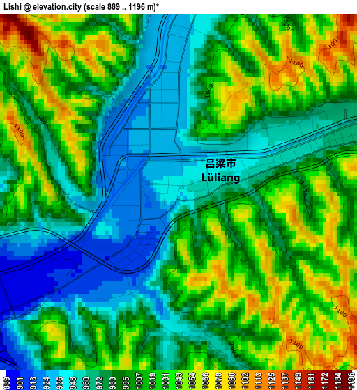
Below is the Elevation map of Lishi, which displays elevation range with different colors. Scale of the first map is from 889 to 1196 m (2917 to 3924 ft) with average elevation of 998.4 meters (=3276 ft) [note 1]
These maps also provides idea of topography and contour of this city, they are displayed at different zoom levels. More info about maps, scale and edge coordinates you can find below images.
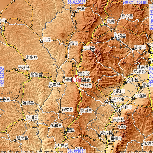
| \ | Map #1 | Topo.Map |
| Scale [m] | 889..1196 m | × |
| Scale [ft] | 2917..3924 ft | × |
| Average | 998.4 m = 3276 ft | × |
| Width | 7.75 km = 4.8 mi | 248 km = 154.1 mi |
| Height | 7.75 km = 4.8 mi | 248 km = 154.1 mi |
| ↑Max Latitude | 37.550409° | 38.62262° |
| Latitude at center | 37.51556° | 37.51556° |
| ↓Min Latitude | 37.480695° | 36.39183° |
| ← Min Longitude | 111.090225° | 109.72792° |
| Longitude center | 111.13417° | 111.13417° |
| →Max Longitude | 111.178115° | 112.54042° |
Nearby cities:
Cities around Lishi sort by population:
• Jiexiu elevation 756 m
87.9 km,  128°
128°
• Zhihe 911 m
92.8 km,  208°
208°
• Longquan 1079 m
92.6 km,  189°
189°
• Tianning 762 m
90.6 km,  87°
87°
• Loufan 1248 m
87.2 km,  42°
42°
• Fengcheng 760 m
79 km,  96°
96°
• Lingquan 973 m
62.9 km,  204°
204°
• Shuitou 1421 m
60.7 km,  173°
173°
• Linquan 1036 m
52.6 km,  349°
349°
• Gedong 1268 m
43.3 km,  14°
14°
• Liulin 940 m
21.6 km,  251°
251°
• Ningxiang 1231 m
20.5 km,  162°
162°
Multilingual:
 En español:
Lishi elevación 943 m.
 En France:
Lishi élévation 943 m.


Sources and notes:
- [note 1] Map square and city borders are not equal. Map elevation data is calculated only from area inside that square.
- [src 1] Elevation data from geonames database provided with same terms of usage.
- [src 2] The elevation map of Lishi is generated using elevation data from NASA's 3 arcsec (90m) resolution SRTM data.
- [src 3] Base (background) map © OpenStreetMap contributors tiles are generated by Geofabrik and OpenTopoMap.
Copyright & License:
This Lishi Elevation Map is licensed under CC BY-SA. You may reuse any part from this page, if you give a proper credit by linking to this URL:
 More info on terms of use page.