Liujiaxia elevation
Liujiaxia (Gansu), China elevation is 1643 meters and Liujiaxia elevation in feet is 5390 ft above sea level [src 1]. Liujiaxia is a seat of a third-order administrative division (feature code) with elevation that is 1085 meters (3560 ft) bigger than average city elevation in China.
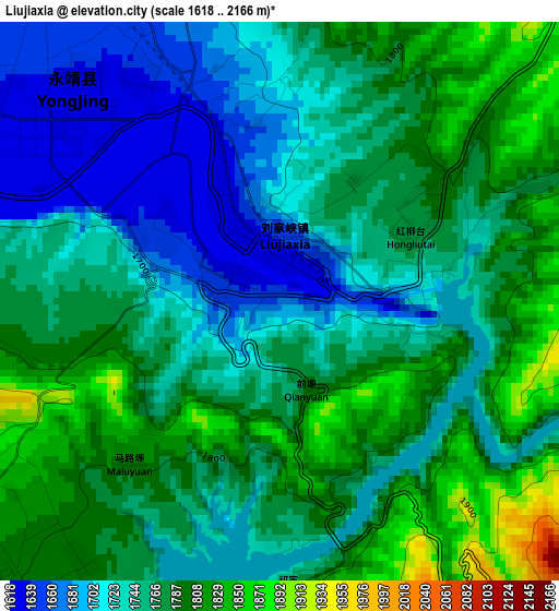
Below is the Elevation map of Liujiaxia, which displays elevation range with different colors. Scale of the first map is from 1618 to 2166 m (5308 to 7106 ft) with average elevation of 1761.2 meters (=5778 ft) [note 1]
These maps also provides idea of topography and contour of this city, they are displayed at different zoom levels. More info about maps, scale and edge coordinates you can find below images.
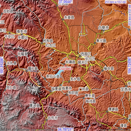
| \ | Map #1 | Topo.Map |
| Scale [m] | 1618..2166 m | × |
| Scale [ft] | 5308..7106 ft | × |
| Average | 1761.2 m = 5778 ft | × |
| Width | 7.91 km = 4.9 mi | 253.2 km = 157.3 mi |
| Height | 7.91 km = 4.9 mi | 253.2 km = 157.3 mi |
| ↑Max Latitude | 35.969574° | 37.0644° |
| Latitude at center | 35.934° | 35.934° |
| ↓Min Latitude | 35.89841° | 34.78721° |
| ← Min Longitude | 103.274365° | 101.91206° |
| Longitude center | 103.31831° | 103.31831° |
| →Max Longitude | 103.362255° | 104.72456° |
Nearby cities:
Cities around Liujiaxia sort by population:
• Lanzhou elevation 1521 m
48.9 km,  73°
73°
• Linxia Chengguanzhen 1893 m
38.5 km,  195°
195°
• Haishiwan 1775 m
61.7 km,  317°
317°
• Hanji 2159 m
56.9 km,  211°
211°
• Hezheng Chengguanzhen 2103 m
56.2 km,  176°
176°
• Guanghe Chengguanzhen 1954 m
55.4 km,  155°
155°
• Zhangyelu 1527 m
47.4 km, 73°
• Chuimatan 2291 m
46.7 km,  239°
239°
• Xihu 1542 m
43.8 km, 70°
• Anning Xilu 1539 m
40.7 km,  62°
62°
• Fulilu 1565 m
32.6 km, 55°
• Suonan 2393 m
30.6 km,  166°
166°
Multilingual:
 En español:
Liujiaxia elevación 1643 m.
 En France:
Liujiaxia élévation 1643 m.
 Auf Deutsch:
Liujiaxia höhe über dem Meeresspiegel ist 1643 m.

Sources and notes:
- [note 1] Map square and city borders are not equal. Map elevation data is calculated only from area inside that square.
- [src 1] Elevation data from geonames database provided with same terms of usage.
- [src 2] The elevation map of Liujiaxia is generated using elevation data from NASA's 3 arcsec (90m) resolution SRTM data.
- [src 3] Base (background) map © OpenStreetMap contributors tiles are generated by Geofabrik and OpenTopoMap.
Copyright & License:
This Liujiaxia Elevation Map is licensed under CC BY-SA. You may reuse any part from this page, if you give a proper credit by linking to this URL:
 More info on terms of use page.