Longmen elevation
Longmen (Fujian), China elevation is 118 meters and Longmen elevation in feet is 387 ft above sea level [src 1]. Longmen is a populated place (feature code) with elevation that is 440 meters (1444 ft) smaller than average city elevation in China.
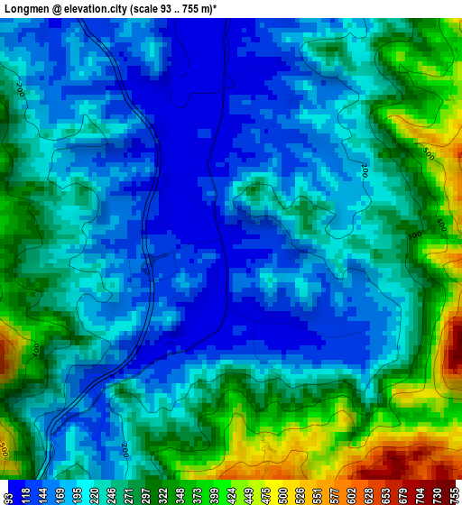
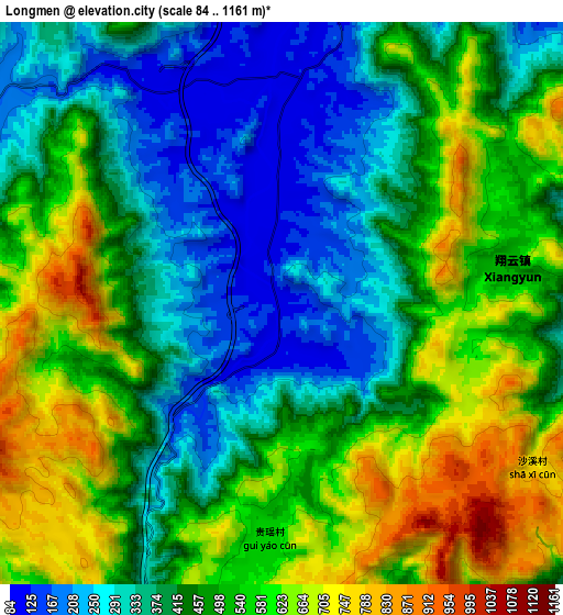
Below is the Elevation map of Longmen, which displays elevation range with different colors. Scale of the first map is from 93 to 755 m (305 to 2477 ft) with average elevation of 242.4 meters (=795 ft) [note 1]
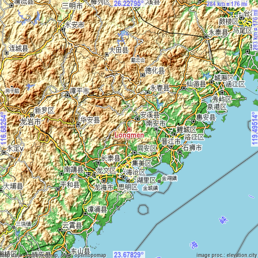
These maps also provides idea of topography and contour of this city, they are displayed at different zoom levels. More info about maps, scale and edge coordinates you can find below images.
| \ | Map #1 | Map #2 | Topo.Map |
| Scale [m] | 93..755 m | 84..1161 m | × |
| Scale [ft] | 305..2477 ft | 276..3809 ft | × |
| Average | 242.4 m = 795 ft | 468.6 m = 1537 ft | × |
| Width | 8.86 km = 5.5 mi | 17.72 km = 11 mi | 283.5 km = 176.2 mi |
| Height | 8.86 km = 5.5 mi | 17.72 km = 11 mi | 283.5 km = 176.2 mi |
| ↑Max Latitude | 24.999555° | 25.039376° | 26.22795° |
| Latitude at center | 24.95972° | 24.95972° | 24.95972° |
| ↓Min Latitude | 24.919873° | 24.880012° | 23.67829° |
| ← Min Longitude | 118.044945° | 118.000999° | 116.68264° |
| Longitude center | 118.08889° | 118.08889° | 118.08889° |
| →Max Longitude | 118.132835° | 118.176781° | 119.49514° |
Nearby cities:
Cities around Longmen sort by population:
• Quanzhou elevation 14 m
50.4 km,  95°
95°
• Ximei 28 m
30.1 km,  84°
84°
• Xindian 27 m
41.8 km,  158°
158°
• Fengzhou 12 m
44.8 km,  90°
90°
• Yingdu 43 m
15.7 km, 85°
• Shijing 16 m
50.8 km,  138°
138°
• Liuwudiancun 10 m
44.6 km,  166°
166°
• Lianhecun 1 m
48.3 km,  148°
148°
• Xiangyun 497 m
7.3 km, 80°
• Neikeng 52 m
42.2 km,  117°
117°
• Taocheng 123 m
44.6 km,  28°
28°
• Fengcheng 50 m
14.4 km,  41°
41°
Multilingual:
 En español:
Longmen elevación 118 m.
 En France:
Longmen élévation 118 m.


Sources and notes:
- [note 1] Map square and city borders are not equal. Map elevation data is calculated only from area inside that square.
- [src 1] Elevation data from geonames database provided with same terms of usage.
- [src 2] The elevation map of Longmen is generated using elevation data from NASA's 3 arcsec (90m) resolution SRTM data.
- [src 3] Base (background) map © OpenStreetMap contributors tiles are generated by Geofabrik and OpenTopoMap.
Copyright & License:
This Longmen Elevation Map is licensed under CC BY-SA. You may reuse any part from this page, if you give a proper credit by linking to this URL:
 More info on terms of use page.