Majie elevation
Majie (Yunnan), China elevation is 1894 meters and Majie elevation in feet is 6214 ft above sea level [src 1]. Majie is a populated place (feature code) with elevation that is 1336 meters (4383 ft) bigger than average city elevation in China.
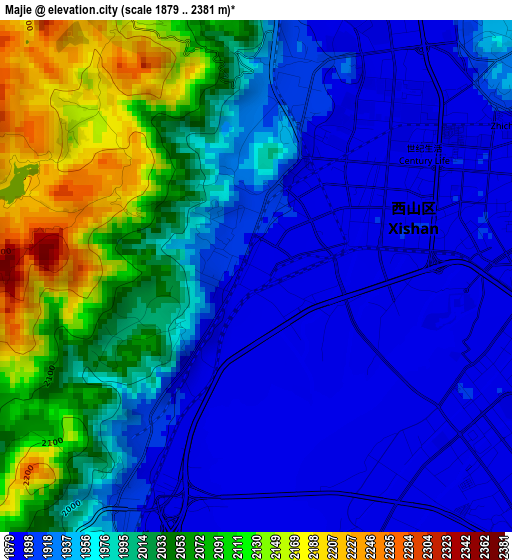
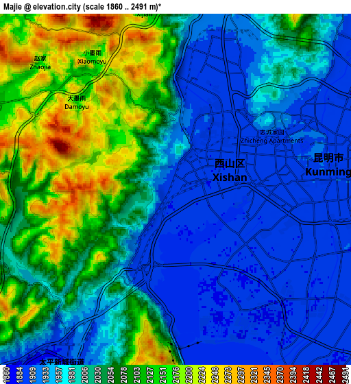
Below is the Elevation map of Majie, which displays elevation range with different colors. Scale of the first map is from 1879 to 2381 m (6165 to 7812 ft) with average elevation of 1979.5 meters (=6494 ft) [note 1]
These maps also provides idea of topography and contour of this city, they are displayed at different zoom levels. More info about maps, scale and edge coordinates you can find below images.
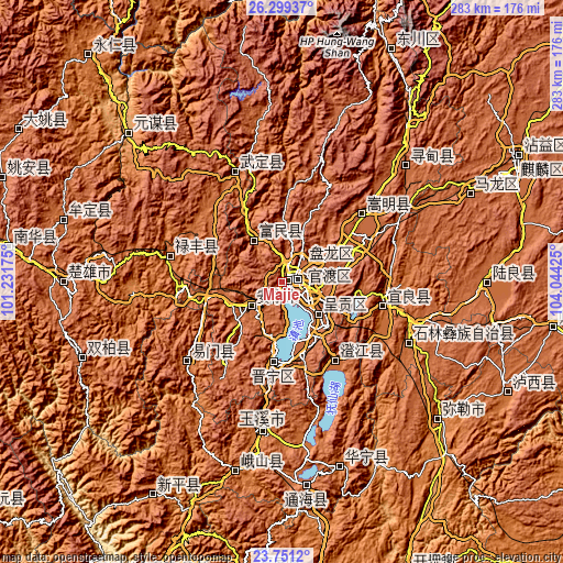
| \ | Map #1 | Map #2 | Topo.Map |
| Scale [m] | 1879..2381 m | 1860..2491 m | × |
| Scale [ft] | 6165..7812 ft | 6102..8173 ft | × |
| Average | 1979.5 m = 6494 ft | 2016.8 m = 6617 ft | × |
| Width | 8.85 km = 5.5 mi | 17.71 km = 11 mi | 283.3 km = 176 mi |
| Height | 8.85 km = 5.5 mi | 17.71 km = 11 mi | 283.3 km = 176 mi |
| ↑Max Latitude | 25.071711° | 25.111509° | 26.29937° |
| Latitude at center | 25.0319° | 25.0319° | 25.0319° |
| ↓Min Latitude | 24.992076° | 24.952239° | 23.7512° |
| ← Min Longitude | 102.594055° | 102.550109° | 101.23175° |
| Longitude center | 102.638° | 102.638° | 102.638° |
| →Max Longitude | 102.681945° | 102.725891° | 104.04425° |
Nearby cities:
Cities around Majie sort by population:
• Kunming elevation 1895 m
8.1 km,  84°
84°
• Haikou 1909 m
28.7 km,  192°
192°
• Lianran 1836 m
19.6 km,  231°
231°
• Jincheng 1759 m
57.4 km,  335°
335°
• Pingshan 1738 m
56.7 km, 343°
• Jinshan 1649 m
55.1 km,  279°
279°
• Kuangyuan 1538 m
53 km,  104°
104°
• Songyang 1909 m
51.2 km,  50°
50°
• Fenglu 1756 m
48.2 km,  145°
145°
• Kunyang 1896 m
40.8 km, 186°
• Yongding 1840 m
25.6 km,  316°
316°
• Longcheng 1945 m
22.1 km,  132°
132°
Multilingual:
 En español:
Majie elevación 1894 m.
 En France:
Majie élévation 1894 m.


Sources and notes:
- [note 1] Map square and city borders are not equal. Map elevation data is calculated only from area inside that square.
- [src 1] Elevation data from geonames database provided with same terms of usage.
- [src 2] The elevation map of Majie is generated using elevation data from NASA's 3 arcsec (90m) resolution SRTM data.
- [src 3] Base (background) map © OpenStreetMap contributors tiles are generated by Geofabrik and OpenTopoMap.
Copyright & License:
This Majie Elevation Map is licensed under CC BY-SA. You may reuse any part from this page, if you give a proper credit by linking to this URL:
 More info on terms of use page.