Hongshui elevation
Hongshui (Gansu), China elevation is 2316 meters and Hongshui elevation in feet is 7598 ft above sea level [src 1]. Hongshui is a seat of a third-order administrative division (feature code) with elevation that is 1758 meters (5768 ft) bigger than average city elevation in China.
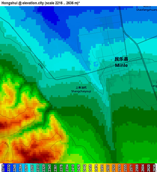
Below is the Elevation map of Hongshui, which displays elevation range with different colors. Scale of the first map is from 2216 to 2636 m (7270 to 8648 ft) with average elevation of 2345.9 meters (=7697 ft) [note 1]
These maps also provides idea of topography and contour of this city, they are displayed at different zoom levels. More info about maps, scale and edge coordinates you can find below images.
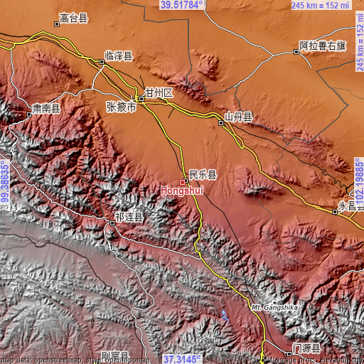
| \ | Map #1 | Topo.Map |
| Scale [m] | 2216..2636 m | × |
| Scale [ft] | 7270..8648 ft | × |
| Average | 2345.9 m = 7697 ft | × |
| Width | 7.66 km = 4.8 mi | 245 km = 152.2 mi |
| Height | 7.66 km = 4.8 mi | 245 km = 152.2 mi |
| ↑Max Latitude | 38.45899° | 39.51784° |
| Latitude at center | 38.42457° | 38.42457° |
| ↓Min Latitude | 38.390134° | 37.3145° |
| ← Min Longitude | 100.748655° | 99.38635° |
| Longitude center | 100.7926° | 100.7926° |
| →Max Longitude | 100.836545° | 102.19885° |
Nearby cities:
Cities around Hongshui sort by population:
• Jinchang elevation 1553 m
122.3 km,  86°
86°
• Zhangye 1481 m
63.9 km,  332°
332°
• Shaliuhe 3302 m
135.1 km,  205°
205°
• Gaotai Chengguanzhen 1357 m
133.6 km,  319°
319°
• Guangzhoulu 1562 m
120 km, 86°
• Ehen Hudag 1504 m
115.8 km,  40°
40°
• Hongwansi 2545 m
113.3 km,  293°
293°
• Yongchang Chengguanzhen 1919 m
108.4 km,  99°
99°
• Shahe 1448 m
95.9 km, 326°
• Nanjie 1468 m
65.2 km, 334°
• Qilian 2758 m
55.3 km,  240°
240°
• Qingquan 1773 m
48.4 km,  32°
32°
Multilingual:
 En español:
Hongshui elevación 2316 m.
 En France:
Hongshui élévation 2316 m.
 Auf Deutsch:
Hongshui höhe über dem Meeresspiegel ist 2316 m.

Sources and notes:
- [note 1] Map square and city borders are not equal. Map elevation data is calculated only from area inside that square.
- [src 1] Elevation data from geonames database provided with same terms of usage.
- [src 2] The elevation map of Hongshui is generated using elevation data from NASA's 3 arcsec (90m) resolution SRTM data.
- [src 3] Base (background) map © OpenStreetMap contributors tiles are generated by Geofabrik and OpenTopoMap.
Copyright & License:
This Hongshui Elevation Map is licensed under CC BY-SA. You may reuse any part from this page, if you give a proper credit by linking to this URL:
 More info on terms of use page.