Nanning elevation
Nanning (Guangxi), China elevation is 91 meters and Nanning elevation in feet is 299 ft above sea level [src 1]. Nanning is a seat of a first-order administrative division (feature code) with elevation that is 467 meters (1532 ft) smaller than average city elevation in China.
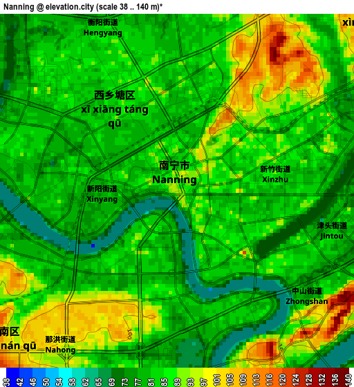
Below is the Elevation map of Nanning, which displays elevation range with different colors. Scale of the first map is from 38 to 140 m (125 to 459 ft) with average elevation of 84.6 meters (=278 ft) [note 1]
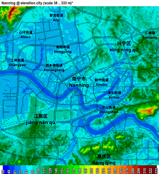
These maps also provides idea of topography and contour of this city, they are displayed at different zoom levels. More info about maps, scale and edge coordinates you can find below images.
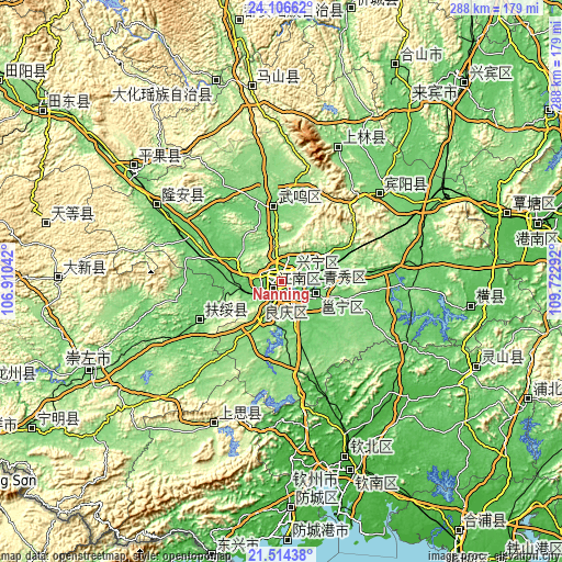
| \ | Map #1 | Map #2 | Topo.Map |
| Scale [m] | 38..140 m | 38..333 m | × |
| Scale [ft] | 125..459 ft | 125..1093 ft | × |
| Average | 84.6 m = 278 ft | 96.5 m = 317 ft | × |
| Width | 9.01 km = 5.6 mi | 18.02 km = 11.2 mi | 288.2 km = 179.1 mi |
| Height | 9.01 km = 5.6 mi | 18.02 km = 11.2 mi | 288.2 km = 179.1 mi |
| ↑Max Latitude | 22.857171° | 22.897659° | 24.10662° |
| Latitude at center | 22.81667° | 22.81667° | 22.81667° |
| ↓Min Latitude | 22.776157° | 22.735633° | 21.51438° |
| ← Min Longitude | 108.272725° | 108.228779° | 106.91042° |
| Longitude center | 108.31667° | 108.31667° | 108.31667° |
| →Max Longitude | 108.360615° | 108.404561° | 109.72292° |
Nearby cities:
Cities around Nanning sort by population:
• Qinzhou elevation 10 m
99.1 km,  161°
161°
• Pumiao 88 m
18 km,  110°
110°
• Lingcheng 70 m
109.3 km, 113°
• Baishan 174 m
100.8 km,  351°
351°
• Hengzhou 63 m
98.4 km,  98°
98°
• Matou 135 m
98.2 km,  307°
307°
• Siyang 226 m
81.7 km,  208°
208°
• Long’an Chengxiangzhen 99 m
80.8 km,  302°
302°
• Dafeng 135 m
74.5 km,  22°
22°
• Luxu 121 m
67.1 km,  47°
47°
• Xinning 94 m
46.7 km,  249°
249°
• Chengxiang 110 m
38.5 km, 354°
Multilingual:
 En español:
Nanning elevación 91 m.
 En France:
Nanning élévation 91 m.


Sources and notes:
- [note 1] Map square and city borders are not equal. Map elevation data is calculated only from area inside that square.
- [src 1] Elevation data from geonames database provided with same terms of usage.
- [src 2] The elevation map of Nanning is generated using elevation data from NASA's 3 arcsec (90m) resolution SRTM data.
- [src 3] Base (background) map © OpenStreetMap contributors tiles are generated by Geofabrik and OpenTopoMap.
Copyright & License:
This Nanning Elevation Map is licensed under CC BY-SA. You may reuse any part from this page, if you give a proper credit by linking to this URL:
 More info on terms of use page.