Pingliang elevation
Pingliang (Gansu), China elevation is 1354 meters and Pingliang elevation in feet is 4442 ft above sea level [src 1]. Pingliang is a seat of a second-order administrative division (feature code) with elevation that is 796 meters (2612 ft) bigger than average city elevation in China.
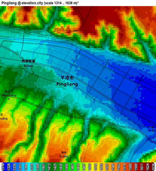
Below is the Elevation map of Pingliang, which displays elevation range with different colors. Scale of the first map is from 1314 to 1636 m (4311 to 5367 ft) with average elevation of 1434.5 meters (=4706 ft) [note 1]
These maps also provides idea of topography and contour of this city, they are displayed at different zoom levels. More info about maps, scale and edge coordinates you can find below images.
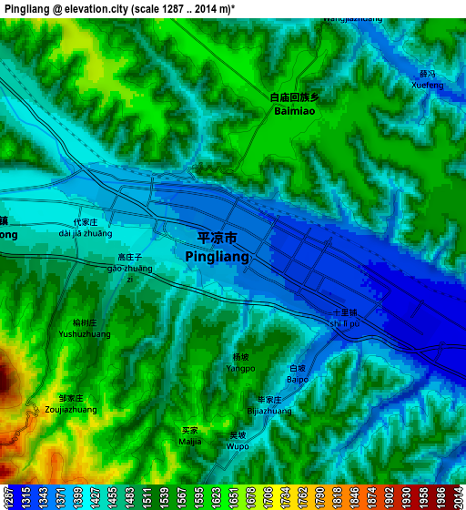
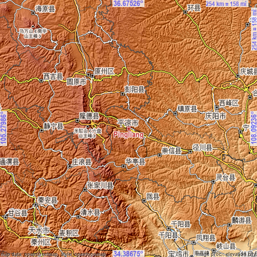
| \ | Map #1 | Map #2 | Topo.Map |
| Scale [m] | 1314..1636 m | 1287..2014 m | × |
| Scale [ft] | 4311..5367 ft | 4222..6608 ft | × |
| Average | 1434.5 m = 4706 ft | 1491.9 m = 4895 ft | × |
| Width | 7.95 km = 4.9 mi | 15.9 km = 9.9 mi | 254.5 km = 158.1 mi |
| Height | 7.95 km = 4.9 mi | 15.9 km = 9.9 mi | 254.5 km = 158.1 mi |
| ↑Max Latitude | 35.574921° | 35.610656° | 36.67526° |
| Latitude at center | 35.53917° | 35.53917° | 35.53917° |
| ↓Min Latitude | 35.503403° | 35.46762° | 34.38675° |
| ← Min Longitude | 106.642165° | 106.598219° | 105.27986° |
| Longitude center | 106.68611° | 106.68611° | 106.68611° |
| →Max Longitude | 106.730055° | 106.774001° | 108.09236° |
Nearby cities:
Cities around Pingliang sort by population:
• Yongqing elevation 1407 m
101.6 km,  210°
210°
• Nanjie 1409 m
88.5 km,  75°
75°
• Jingning Chengguanzhen 1663 m
87.2 km,  268°
268°
• Zhangjiachuan 1671 m
75.1 km,  215°
215°
• Longxian Chengguanzhen 973 m
71.8 km,  168°
168°
• Jingchuan Chengguanzhen 1033 m
65.3 km,  110°
110°
• Longde Chengguanzhen 2091 m
52.1 km,  278°
278°
• Zhenyuan Chengguanzhen 1178 m
48.6 km,  71°
71°
• Jinping 1148 m
39.9 km,  128°
128°
• Donghua 1435 m
36.1 km,  184°
184°
• Baiyang 1472 m
34.9 km,  353°
353°
• Xiangshui 1954 m
32.9 km,  257°
257°
Multilingual:
 En español:
Pingliang elevación 1354 m.
 En France:
Pingliang élévation 1354 m.
 Auf Deutsch:
Pingliang höhe über dem Meeresspiegel ist 1354 m.

Sources and notes:
- [note 1] Map square and city borders are not equal. Map elevation data is calculated only from area inside that square.
- [src 1] Elevation data from geonames database provided with same terms of usage.
- [src 2] The elevation map of Pingliang is generated using elevation data from NASA's 3 arcsec (90m) resolution SRTM data.
- [src 3] Base (background) map © OpenStreetMap contributors tiles are generated by Geofabrik and OpenTopoMap.
Copyright & License:
This Pingliang Elevation Map is licensed under CC BY-SA. You may reuse any part from this page, if you give a proper credit by linking to this URL:
 More info on terms of use page.