Xi’an elevation
Xi’an (Shaanxi), China elevation is 416 meters and Xi’an elevation in feet is 1365 ft above sea level [src 1]. Xi’an is a seat of a first-order administrative division (feature code) with elevation that is 142 meters (466 ft) smaller than average city elevation in China.
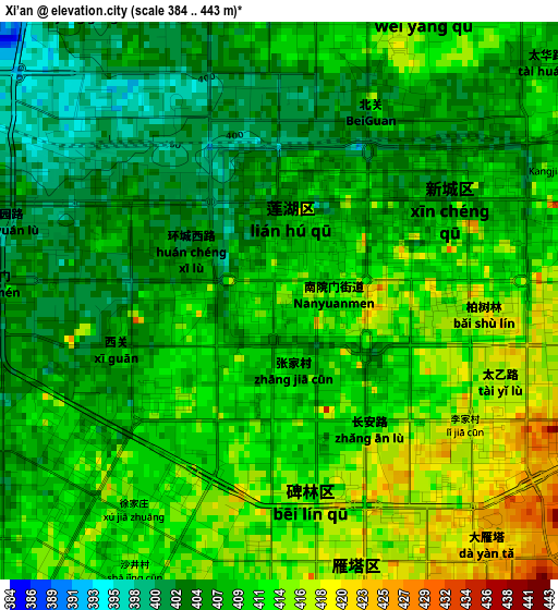
Below is the Elevation map of Xi’an, which displays elevation range with different colors. Scale of the first map is from 384 to 443 m (1260 to 1453 ft) with average elevation of 408.9 meters (=1342 ft) [note 1]
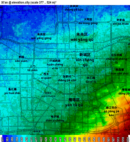
These maps also provides idea of topography and contour of this city, they are displayed at different zoom levels. More info about maps, scale and edge coordinates you can find below images.
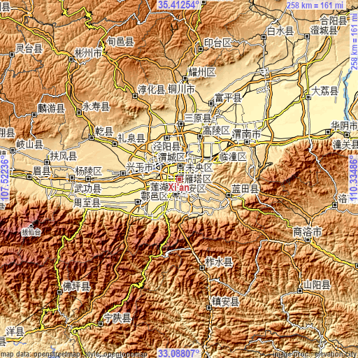
| \ | Map #1 | Map #2 | Topo.Map |
| Scale [m] | 384..443 m | 377..524 m | × |
| Scale [ft] | 1260..1453 ft | 1237..1719 ft | × |
| Average | 408.9 m = 1342 ft | 412.7 m = 1354 ft | × |
| Width | 8.08 km = 5 mi | 16.15 km = 10 mi | 258.5 km = 160.6 mi |
| Height | 8.08 km = 5 mi | 16.15 km = 10 mi | 258.5 km = 160.6 mi |
| ↑Max Latitude | 34.294643° | 34.330941° | 35.41254° |
| Latitude at center | 34.25833° | 34.25833° | 34.25833° |
| ↓Min Latitude | 34.222001° | 34.185656° | 33.08807° |
| ← Min Longitude | 108.884665° | 108.840719° | 107.52236° |
| Longitude center | 108.92861° | 108.92861° | 108.92861° |
| →Max Longitude | 108.972555° | 109.016501° | 110.33486° |
Nearby cities:
Cities around Xi’an sort by population:
• Xianyang elevation 387 m
22.6 km,  293°
293°
• Lintong 425 m
29 km,  62°
62°
• Ganting 414 m
33.7 km,  239°
239°
• Jinggan 409 m
31.4 km,  343°
343°
• Qindu 389 m
22.3 km, 294°
• Weicheng 383 m
21.1 km, 292°
• Chang’an 439 m
12 km,  172°
172°
• Yanta 431 m
6.2 km,  159°
159°
• Weiyang 409 m
3.6 km,  10°
10°
• Beilin 414 m
3.5 km,  199°
199°
• Xincheng 412 m
2 km,  74°
74°
• Lianhu 413 m
0.4 km,  272°
272°
Multilingual:
 En español:
Xi'an elevación 416 m.
 En France:
Xi'an élévation 416 m.


Sources and notes:
- [note 1] Map square and city borders are not equal. Map elevation data is calculated only from area inside that square.
- [src 1] Elevation data from geonames database provided with same terms of usage.
- [src 2] The elevation map of Xi’an is generated using elevation data from NASA's 3 arcsec (90m) resolution SRTM data.
- [src 3] Base (background) map © OpenStreetMap contributors tiles are generated by Geofabrik and OpenTopoMap.
Copyright & License:
This Xi’an Elevation Map is licensed under CC BY-SA. You may reuse any part from this page, if you give a proper credit by linking to this URL:
 More info on terms of use page.